Thursday, December 16, 2010

Dec 7 Angels Landing


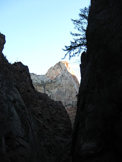
View the angels have

The trail to Angel's Landing starts innocently enough, a mostly paves path switchbacking its way up the canyon wall. The trail briefly follows a slot canyon before heading up a series of very steep, stone lined switchbacks. I can't believe someone actually built this trail. There is a resting spot at Scout's Landing.

No angels here

I looked out at the wall in front of me and wondered where the trail went. Surely it did not go up that tower with no discernible route. Where else could it go?

Yes, that is the way

The best way to find out where the trail goes, is to follow it. I knew it couldn't go up that tower. The closer I got the more convinced I was, no way. As you have guessed, that is where it went. Poles with a chain slung between them offered all the comfort you'd get on this trail. I passed a German couple making their way down. they had been the first of the day up and declared it would be all mine. I pushed on. The path narrowed to a couple feet wide with drop offs on both sides, straight down, thousands of feet.

I ran into an icy patch in a very precarious spot. Twice I failed to make it over the ice. I sat down on the rock and tried to decide what to do. Turn back? I looked back and there at Scout's Landing was the German couple staring up at me. How could I turn back now with this international reputation on the line. I managed to get over the ice and on to the top. For the 45 to 60 minutes I was up there, 5 others managed to make it to the top. The view is one of the best in America. Not only are you looking down canyon but also up canyon. Angel's landing is stuck out in the middle of the canyon rather than a side wall.

Big drop on both sides


Dec 7 Virgin River narrows


The Virgin River is responsible for cutting Zion Canyon in Utah. If you follow the river upriver through the gorge it appears the canyon ends in a dead end.


This obviously is not the case, the river continues but the canyon narrows to a little as 20 feet in places. Remember, the sheer rock wall continue to be over a thousand feet vertically.


Narrow canyons like this pose tremendous threats to those who wade up the "slot" canyons. Any rain can raise water levels. Folks have been caught in these situations and perished. There was simply no where to go, no high ground, no outrunning the water, no surviving in the water as it rushes downriver.


I spoke with a local outfitter who rents equipment for walking upriver. This time of year it includes dry suits and waterproof footwear. They provide shuttle service to point upriver so you may walk in the river to the end of the Zion Canyon Road. That walk is about 10-12 hours and not available this time of year anyway due to closed roads.

Dec 2 Moore's Wall Scramble

Looks like an Indian Face

We started our scramble at the climbers parking area west of Hanging Rock State Park. It is barely a 15 minute walk from here to the wall. The imposing wall presents no easy routes up. Without the technical skills or equipment, we had to walk along the base looking for a scramble route up. Probably 300 yards from our starting point we found such a place and managed to hit the Moore's Knob Loop trail at the top. We had to cut through many briers on the way up. It was barely a 20 minute walk to the tower. We visited Balanced Rock before heading down the trail.


This is a spire near Indian Face

We made our way out to the top of Indian Face through a brutal mess of briers and laurel. It does not appear many folks venture out to this spectacular outcrop. Views were worthy of a lunch break.

Angry Ben surveys the earth below

After our break, we headed down a wide gully beside Indian Face. Immediately, we were stunned by the sheer size of the wall and the formations we saw every few steps. Climbers have worn paths along the wall and the hiking was almost an easy stroll. Spires, caves, rock overhangs etc proliferate here.


A spire creates a narrow passage

We made it full circle, back to our starting point and the climbers access trail back to the parking lot.

Nov 19 Quechee Gorge

  At 165 feet deep, Quechee Gorge is the deepest gorge in Vermont. The Ottauquechee River flows through it. The name is derived from a Natic...