Sunday, April 16, 2023

Apr 11 Devils Marbleyard


Wow, just wow. This is a pretty stunning place. Devils Marbleyard is not marble but is a devilish jumble of rocks. I'm doing an 8.3 mile loop hike to visit the boulder field. Beginning at a small parking area at the entrance to Camp Powhatan, a boy scout camp now in ruins, I begin in chilly weather. The Belfast Trail takes me about a mile and a half to the beginning of the rock jumble. As I approach, I see what looks like smoke. As I draw closer. I realize it is not smoke. It is this pile of gray rocks.


I parked beside this bridge which led the way to the camp entrance. 


The camp which opened in the 1930s, now lays in ruins. There are many stone foundations and trails here. 


Shortly after passing the old camp you enter the wilderness. It is a very rocky uphill trail that leads to the boulder field. 


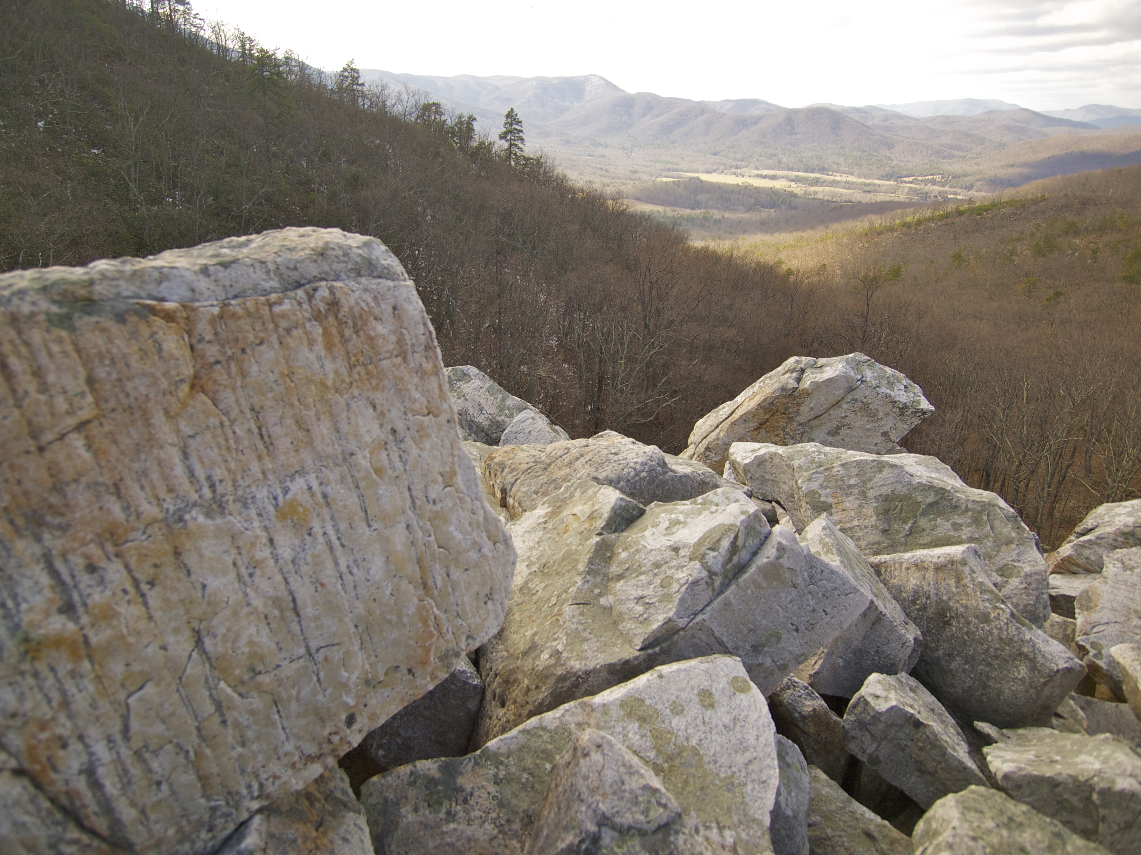
This is my first glimpse of the boulder field. My first thought was a glacier deposited these rocks. It reminds me of the erratic rocks of southern Connecticut, my home as a youngster. Of course that is not how they got here. One of my favorite bloggers, Mary Caperton Morton writes in her fabulous blog-Travels with the Blond Coyote:

So what happened here? As it turns out, the bizarre and beautiful geology of the Devil’s Marbleyard tells a story of ancient beaches, extinct worms, supercontinents and ice crystals. According to the U.S. Geologic Survey, the white rocks of the Marbleyard began as a white sand beach, much like the Outer Banks of North Carolina, around 500 million years ago. The sand was riddled with worms, which left behind copious worm-track tunnels as they moved through the sediment.

Over a period of several hundred million years, the beach was buried and the quartz-rich sediments were compressed and baked into quartzite, one of the hardest metamorphic rocks on the planet. A few of the worm tracks were preserved, all in one parallel plane; tracks in other orientations were obliterated.

Looking back down into the Natural Bridge valley

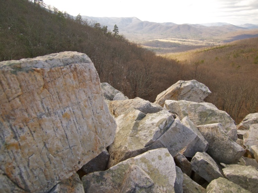
Looking back down into the Natural Bridge valley, worm tracks on the left. This rock is classified by the USGS as Antietam Quartzite.

Then around 325 million years ago, the continental plate under what is now North America (then known as Euramerica) began colliding with the African plate (known as Gondwana), eventually forming the supercontinent Pangaea and pushing up the Appalachian Mountain chain to Himalayan heights.

For more than 200 million years, the hard quartzite of the Marbleyard lay intact, within the bowels of the mountains, until it was eroded to the surface, largely still in one piece. Then, ice went to work on the rocks, but not in the spectacular glacier-driven methods I imagined. Instead, tiny ice crystals found their way into cracks and fissures in the rocks, perhaps along the ancient worm-trails, and when the ice expanded, it cracked the rocks. Eventually, the entire quartzite ridge tumbled downslope, creating the Devil’s Marbleyard.

The moral of this story: given enough geologic time, worms can bring down mountains!

If you want a more fanciful account of the rocks' origin, another blog I follow is Virginia Trail Guide by Christine and Adam: 

 In the local tale, this area was occupied by Native Americans and the land was supposedly very green and lush.  There was a large stone altar at the top of this hill that was used for worship on full-moon nights.  A white couple met the Native Americans and they were thought to be spirits since they looked so different than the local tribes.  The couple said they were not spirits but they worshiped a higher power.  They converted the Native Americans to Christianity.  However, the next year brought about a great drought and the Native Americans felt the new God and the missionaries were to be held responsible.  They burned the couple alive on the altar.  As the flames reached high into the sky, a storm formed.  Lightning struck down upon the altar and exploded the rock over the mountainside.


The trail approaches the boulder field straight on but moves to the right to follow the periphery of the field. You can enter the rocks at several places but it is a tough scramble to move about. I have read that snakes occupy this area as you might expect. The rocks are of many sizes with the largest being as large as my pick-up. Nothing grows here as I imagine the boulder field is quite deep. Judging depth from the transition area, I's hazard a wild guess that it could be 20 feet deep. 


Eventually, the trail deviates lower and away from the rocks into a ravine. So, I did not get to see the top of the boulder field. 


The trail becomes less rocky and eventually ends at the AT. To the right (southbound) it is about a mile to "the helicopter pad", an open area with spectacular 360 degree views. However, recent trail comments indicate this area has overgrown and is no longer a scenic spot. So, I turn left and go northbound.


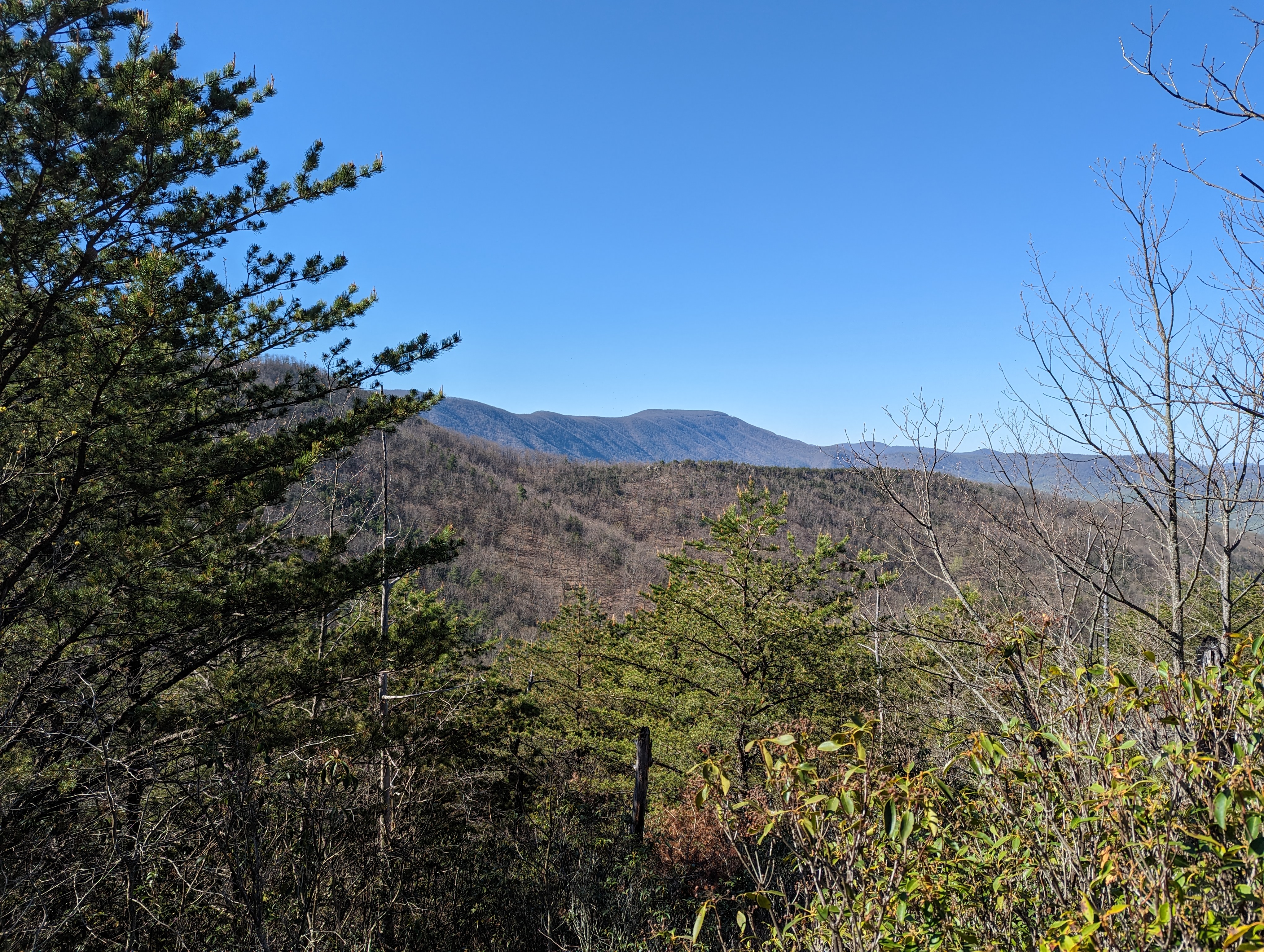
This is a ridge walk for a mile or more before heading downhill with 14 switchbacks. It is easy to see this on a map or gps track. The trail is fabulous with several viewing areas. It was loaded with a couple varieties of Azalea, Dog Hobble, Iris, Gay Wings and Birdsfoot Violets. 


The last 3 miles of my hike were on the Glendale Horse Trail. It was a wide two track, so a boring ending to an otherwise spectacular hike.


Apr 10 Dragon's Tooth


Dragon's tooth shows up in Greek Mythology. There was a rock near Singapore that bore that name until it was destroyed to widen entry to a harbor. There is a Dragon's Tooth cave in Florida. It's a wine, drill bit and who knows what else. If you are an AT hiker, then Dragon's Tooth is part of the Virginia Triple Crown. Granted, MacAfee Knob may get more visitors. It is a much easier hike than the tooth.

Having never hiked here, I didn't know what to expect. I opted for the Dragon Tooth Trail route for the hike up. Combining that with the AT and the Boy Scout Trail, it was a 6 mile loop hike. 

Gay Wings

The trail began as a wide boulevard and quickly entered a nice flat area beside the creek. This was a perfect spot for a homesite. Eventually, I saw a collapsed building. The roof was still intact but laying on the ruins of the rest of the building. 


It was a pleasant climb up to the ridge the AT traveled along. The upper portion of this was loaded with large flowering Bellwort. The trail intersected with the AT in a slight gap, grassy and swept clean by winds. My route took me southbound on the AT for about a mile. Just before attaining the high ridge where the Dragon Tooth resides, the trail climbs almost straight up through a series of vertical rock faces with just enough hand holds and foot steps chipped into the rock. Carrying a backpack through here requires an intrepid effort. I read this was the toughest AT mile south of the Whites.  


A short side trail leads to Dragon Tooth. Impressive rock formations surround the tooth. It can be climbed for a stunning view. Although it does not look safe to climb, there is a route to the very top that most folks can do. This was my lunch spot. Better than any restaurant table. And no reservations for that special seat is needed.

Exploring the area

That is MacAfee and Tinker out there.

My first sighting of 2023 Trailing Arbutus.

Healthy Birdsfoot Violets populate this section of the AT.


My return was on the AT almost all the way to the MacAfee parking area, turning back to Dragon Tooth Trail's head on the Boy Scout Trail. 


One of those vertical trail routes. The white blazes go up in what looks like an inaccessible route. It was easier than it looks here.


Returning on a long AT ridge, I'm seeing this landscape much of the way. The trail is in great shape and the rockwork is quite impressive. 


I'll caulk this hike up as a keeper. It is slow going for a bit while you are quite busy watching where to put each step. It was great to see a couple families make the trek. I hope that last rock climb didn't turn any of them back. 


Friday, April 14, 2023

Mar 31 Brewhouse Mountain


Welcome to Jeff Lebo's Brewhouse Mountain


The dilemma that Jeff faced back in the 1990s was "where can I display my beer can collection. A problem many of had. Instead of paring back the collection or specializing in something, he wanted it all. His collection which now numbers over 100,000, was not suitable for a game room or basement. The solution was to build a house for them. Still that isn't large enough but it'll have to do for the time being. 


It's not just beer cans. There are collections of cans for potato chips, coffee, oil, pretzels and even lard. There are brewery advertising pieces of all types, pocket watches, Americana and much more. Every time I visit, I see something I didn't notice before.


Jeff and wife Laurie are fabulous hosts. There's always snacks, beer and soda when they have open house days. 


The first floor has a large living room, dining room and kitchen. All decorated with beer cans. The second floor boasts this bar and game room pictured above. Then there are several bedrooms, all featuring regional cans. There are separate rooms for Germany, Scandinavia, Australia etc. These rooms aren't large enough to house all the cans Jeff has from those regions. So, he built moving shelves. Each room has shelving 3 deep. 


Movable shelving above. Check out the runners for the shelving. 


This hallway is about as narrow as it can get. There are many cans here that are on shelves or stacked up and can't be seen. Hmmm.


Almost no space has gone unoccupied.


The kitchen display

Yep, even the bathrooms


Mar 31 Devils Racecourse & Horse-Shoe Trail


My hike today is on the AT just north of Harrisburg PA. After a couple hours on the AT, a sidetrail, the Horse-Shoe Trail heads 140 miles southeast to the Philadelphia area. My route included only 1/2 mile of this trail, just to the Devils Racecourse.

With a name like "Devils Racecourse", naturally, one is curious. Pennsylvania has a series of long NE/SW oriented mountains. If you look at a roadmap of the state, this is obvious. The racecourse is in the valley between two such mountains. Over time, rock outcrops on both mountains, slowly made there way down to the bottom. I'm told this occurred in periglacial conditions. 


Starting out at Clark's Creek trailhead on the AT, I walked through pleasant woods, not far from the creek. It was not long before I came to an old homesite. This one was ablaze with Forsythia and tiny yellow trumpet daffodils. 


The AT followed an old road with rockwork here and there. There was evidence of coal deposits as well. I saw a number of pits, some of which had coal piles nearby. 


Looking uphill as I walked, rocks were piled everywhere. AT hikers hate the Pennsylvania rocks. 

Siberian Squill


Finally, the trail smoothed and I didn't have to watch every step of the way. When I reached the highest point, there was a gap allowing an easier route to the valley between the mountains. 


That is where the terminus of the 140 mile Horse-Shoe Trail is located. It is called Horse-Shoe since this is both a trail for riders and hikers - Horse and Shoe. However, it does appear to be quite old. On one map, it was called Stagecoach Road. The trail opened in 1935 and is cared for by the Horse-Shoe Trail Conservancy. The trail is a mishmash of  public lands, easements and  agreements with private landowners. 


It was a short hike down a rocky trail to the valley below and the racecourse.. 


As I approached the bottom, I passed a series of foundation walls, spaced within about 50 feet of each other. There were 6 or 7 of these. They were small and possibly small one room cabins.


The racecourse is about 100 feet wide and I am told extends 3300 feet with additional rocks mixed with trees for about a mile. Rattling Run Creek flows underneath the rocks. I could hear water but could not see it. Local lore says the water noises were the devil roaming the depths of hell. 


After some exploration, I'm headed back the way I came. The total distance was between 8 and 9 miles. 


Great rockwork along the AT

Apr 24 Riles Creek Paddle

  Riles Creek drains into Tuckertown Reservoir. Today's paddle was organized by Crystal and most of these Photos were taken with her zoo...