First Day on the Trail
Today the Liles, Richs and Petru-Plants begin the 84 mile trek along Hadrians Wall Path. Our group has spent the previous night in Tynemouth, a suburb of Newcastle. Tynemouth is a resort town with a small town feel to it. Having gotten off the plane around noon and made our way via local rail, we managed to walk about the town but by early evening, five time zones caught up and it was lights out. Well, not exactly, it doesn't get dark until about 10:30pm and shortly thereafter, at 4am, it is light again.
Our hostess, Sally Craigen, has prepared an exceptional breakfast. Shortly after, we bid Martineau House goodbye and walk to the train station. A quick ride of only a few stops, brings us to the appropriately named village of Wallsend. Here we just needed to gather our bearings and walk to the River Tyne where our journey along the wall was to begin. It is raining. What do you expect? Some of us with umbrellas, others with rain jackets, and all very excited to get on with this walk across England.

We walk in woods, along the Tyne and through villages and the urban area of Newcastle. The scenery changes. There is urban decay and blight, urban renewal, pretty forest, some littered spots and lots of flowers. So, a real mixed bag for us today. The only thing missing, was the wall. We had read that the quarried stones which the Romans used, have since been plundered from the wall for use as building material over the last 1895 years. The Emperor Hadrian had the wall built in 122 AD. I thought we might spot some crumpled wall here or there but no. It was not there and there was no sign of the earthworks which accompanied the wall.
A palm tree in Newcastle? The weather was hardly balmy. The wind made umbrella holding rather tricky. After passing through the downtown area of Newcastle, I began to feel our adventure was beginning. Still we proceeded right along the Tyne.
A fellow traveler sports the latest in Hadrian Wall wear. His boots were supposed to be waterproof. Looks to me like they are now. The plastic kilt is nice addition. He was gracious to allow us to photograph him without charging modeling fees.
The day wears on and the rain finally stops. We are close to our destination but decide to have a late lunch at a pub - the Boathouse. Taking off our wet gear feels great. Having a couple beers is not bad either. We head on and shortly arrive at the site of the Battle of Newburn. According to Wikipedia:
The Battle of Newburn, sometimes known as Newburn Ford, was fought on 28 August 1640[2] during the Second Bishops' War[3] between a Scottish Covenanterarmy led by General Alexander Leslie and English forces commanded by Edward, Lord Conway. Conway, heavily outnumbered, was defeated, and the Scots went on to occupy the town of Newcastle, obtaining a stranglehold on London's coal supply. Charles I had no choice but to agree on October 26 to the Treaty of Ripon, under which the Scottish army in northern England would be paid daily expenses, pending a final treaty of peace. To raise the necessary funds Charles had to call the Long Parliament, thus setting in motion a process that would lead to the outbreak of the English Civil War two years later.
Also at this spot was our accommodation for the evening, The Keelman. By chance, it was part of a small complex which included this brewery. And, I didn't even plan it this way.
Second Day on the Trail

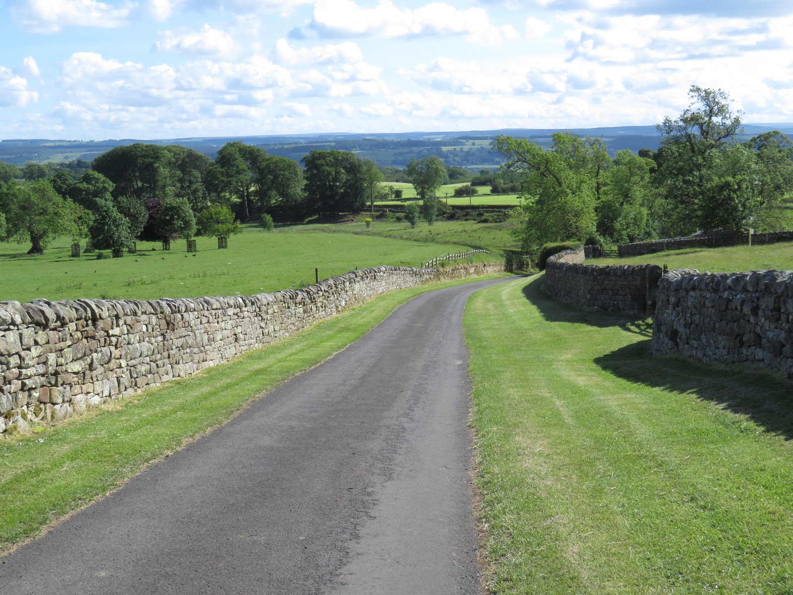
Today is a longer day, 14 miles on the trail and another 2.4 miles to Corbridge via some country lanes. We begin walking along the River Tyne and pass through some large fields. We stop for a bit to speak with a local gal out walking her dogs and learn more about the local area. Not long after this, the trail turns away from the river and begins an upward climb to the small town of Heddon on the Wall. Walking up above the valley, offered us the first longer range view of the area. We could see back toward Newcastle and the Tyne valley. There was a wonderful looking pub, The Swan, at the top of the hill. It was too early for it to be open. Otherwise we wold have stopped for the great view from its dining room. Not far from here, there was a section of wall, the first we have seen. It is about 200 yards long and just a foot or two high. The construction of the wall was to use quarried stones on the exterior. These were cube shaped. At about 5 feet thick, the interior was filled with fieldstones. Over time, the quarried stones found their way into other buildings, leaving a lot of the interior fill remaining in place.
A few minutes after stopping here, the sky darkened and we quickly donned rain gear. For the next mile, we walked beside a wet road with fast traffic, wondering when the weather gods would relent. They did, about the time we left the road and entered a sheep pasture. Here we met a fellow hiker, from St Louis. He was familiar with the furniture companies in our area of North Carolina. We spoke for a while, then separated. We would meet this fellow numerous other times along the walk, including the last nights' stay and at the train station the day after our hike.

We passed through many gates, like the one above and the more popular kissing gates. In and out of the rain, much of the rest of our morning was spent next to a road, separated by a hedgerow. In the early afternoon, we managed to stop a pub, Robin Hood Inn, for some lunch. We huddled about the table to plan our logistics for the final few miles. Our accommodation was located 2.4 miles off the trail. The tour company we used, was willing to pay transportation costs for the extra walk but several of us opted to make our way through the countryside to town. At this point, we split up with Carol and the two Jims willing to do the extra miles.
The directions were cryptic but somehow we managed to stay on course through the prettiest countryside we had experienced yet. We walked by a magnificent manor house with private chapel and many beautifully fenced fields.

It seemed to take us forever but we finally arrived at our B&B, Norgate. I was shocked to learn that our fellow hikers also had just arrived. Their journey had become an ordeal. Opting to call a taxi, early on, they were told the driver had some personal business to do and would be about an hour. This forced them to walk along the road rather than the trail which was nice and safely located away from the road. Finally, they decided to call the B&B and ask for assistance. This resulted in the B&B owner making the drive out there and the taxi driver trying to figure out what was going on. The small drama continued into the evening as we were eating dinner in a downtown pub, The Black Bull. We learned the taxi guy was there with his wife. Thinking that he might be annoyed at missing a fare and searching for the people he was to pick up, a bottle of wine was sent to his table. I don't know if he was upset, but they drank the wine and all was good as far as we were concerned. In this town, everybody knows everybody (and their business).

Third Trail Day
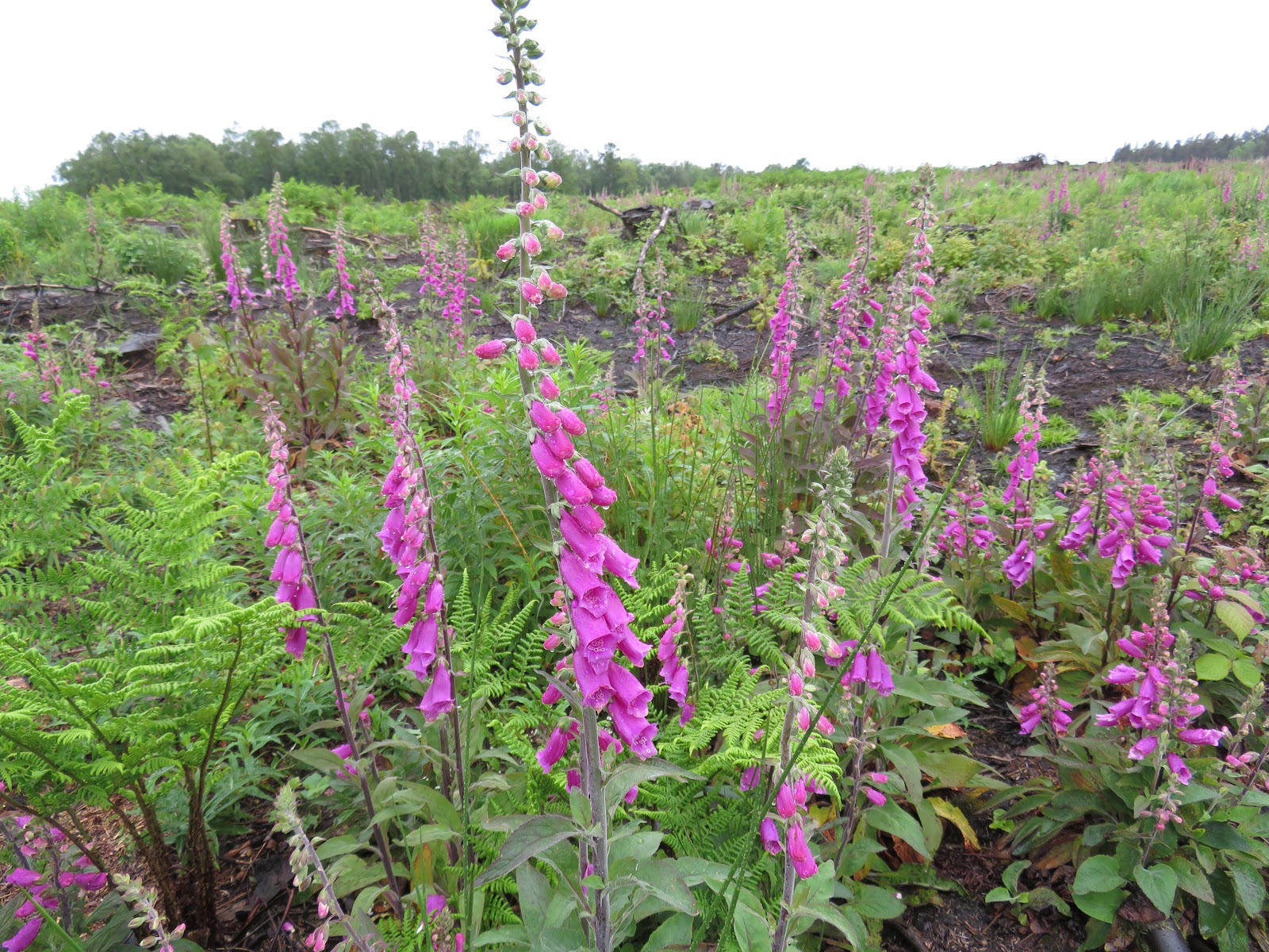
After a lovely breakfast prepared by Peter, we don our rain gear for another bout of wetness. This one looked to be more tenacious than the light rain we had experienced on the past two days. Peter rode us out to the trailhead and we climbed over the stone wall to begin our trek today. We began in a recently clear cut area. The foxglove here was stunning. I dropped back from the group to take photos and took a while to catch up.
We are lucky that our walk today is only 6 miles as it was raining.
Below you can see the "ditch". On the north side of the wall, a v shaped ditch was build as a final obstacle for those who wished to attack the wall.
Apparently there are numerous St Oswald churches in the UK. Above is one of them. We were very happy to stop at this one to get out of the rain. Here is what wikipedia has to say about Oswald:
Oswald was the son of
Æthelfrith of Bernicia and came to rule after spending a period in
exile; after defeating the British ruler
Cadwallon ap Cadfan, Oswald brought the two
Northumbrian kingdoms of
Bernicia and
Deira once again under a single ruler, and promoted the spread of
Christianity in Northumbria. He was given a strongly positive assessment by the historian
Bede, writing a little less than a century after Oswald's death, who regarded Oswald as a saintly king; it is also Bede who is the main source for present-day historical knowledge of Oswald. After eight years of rule, in which he was the most powerful ruler in
Britain, Oswald was killed in the
Battle of Maserfield.
St Oswald's Way is a popular trek route. This is one end of it. Very near the church is this wonderful ancient tree.
We walk through a forest before coming out on a very narrow road in which cars can't pass one another. Nor can hikers pass a car without a tight squeeze. Then there is a short road walk into Chollerford. Near here is the Chesters Fort and Roman ruins. Below is the stables and barracks. The drain is to run off horse urine. Yes, it must have smelled lovely here.
Above and below are ruins of the Roman bath house. The structure contained a number of rooms, all for different purposes. There was a wet bath, a dry room (sauna), a cool down bath and of course a wood fired boiler to keep the water heated, as well as reception area.

After viewing the ruins and eating lunch in the tea room, we walked back to Chollerford and then a short road walk to Humshaugh and Linden House our place for the night. This was a large home. Our room was roomy and we had a massively sized bathroom. Our evening meal was just steps away at the Crown Inn, in which I had one of the best meals of the trip. We explored town a bit but there wasn't much here. Nanci and sat in the Linden House yard drinking wine late into the evening. Our host, Dick came by to speak. We learned the next day that Dick owned a race horse. He didn't really want to own it but he did and decided to hire a top trainer from Ireland. The horse won its first race and went on to become horse of the year, making Dick a bundle of money.
Fourth Day of Walking
Supposedly these stones are from the road the Romans built to transport their army. The road along the wall is still called the "Military Road".
We start our walk along a road to hook up with the trail near Chesters Fort. Once on the trail, we walk across expansive meadows accompanied by the ever present sheep, occasional cow and a few fellow hikers. The wall is making its appearance now in a grander way. There are long stretches of wall, still partially plundered. Looks like rain!
The wall structures and earthworks consist of a ditch to the north, the wall itself with a facade, the Military Way (a paved Roman road added later), the north mound, vallum and south mound. The mounds and vallum allowed the military to move, on horseback, without being seen.
A bit about the wall's construction: The wall is 80 Roman miles which are 73 of our miles. The trail is a bit longer at 84 miles because it meanders here and there. Construction began 122 AD during the reign of Emperor Hadrian. It took about 6 years to complete. His strategy was to consolidate the empire, not expand it. No one is quite sure why the wall was built. It must have been expensive and it required an army to maintain. Was it really worth defending against the tribes to the north? There could not have been enough trade going on with the tribes to justify a wall in order to control trade, collect duties and taxes. Any raids or cattle rustling in this frontier could not have justified the expense. In any case, it was built.
In the east, the wall is 10 feet thick (broad wall) and in the west it is about 1/2 that. It varies in spots for a variety of reasons. Roughly half way, the geology changes. Limestone in the east was easy to quarry and shape but rock in the west was harder and more difficult to quarry. Thus, the western part of the wall was originally earthen and built 20 feet thick. Later it was rebuilt much narrower, with stone. In the east it is 16-20 feet tall and varies in the west, often much shorter, especially in the crags. There was a southern defensive nature to the wall in the west, as the Romans had trouble with the tribes to the south. For every (Roman) mile there is a small mile castle and 2 turrets between each milecastle. Larger forts were placed in strategic locations along the wall. Rivers in the east and west, served as barriers too. Of course the wall was built along the crags for its strategic advantages. So, the Romans chose this locale more for its convenient location. Roman towns to the north became vulnerable and the two towns along the wall, now Corbridge and Carlisle, gained in importance.


It is extremely windy today. The forecast was for steady winds at 35 mph and gusts to 50 mph. I believe that was accurate. Had it been raining; I don't want to even think of what that would have been like.


Above is the ruin of a Mithraic temple. Mithraism was the unofficial religion of the Roman Army. Little is know about this faith and where it began. There were 7 levels or ranks that followers rose through. Near here was found an "ordeal pit" used for the initiate to rise to the next level. Often the ritual involved physical trail by fire, cold or fasting. As one rose from the lowest rank, Raven up to the highest, Father, he would learn secrets of the faith at each level. At the core of the faith is the god Mithras. He was born from a living rock or tree. His life was filled with hardship and suffering until it culminated in the slaying of the primeval bull. This event unleashed the power of the bull toward humanity. From its body came herbs and plants. From its semen came cattle and domesticated animals. From its blood came wine. The temples, like the one above would have been built underground to simulate the cave in which Mithras slay the bull.

The pavers disappear into the mud manure. We had to find another way through here. My boots were never the same.
We hiked well into the afternoon. As the day wore on, we were unable to find any respite from the wind. We could not even eat our lunch. Finally, we hunkered down in a small spot sheltered from the wind by the wall. It was a very scenic spot. The wind rattled the trees nearby as we ate.
Continuing on in the area known as "the crags". Here the earth dropped off abruptly. The Romans didn't really need a wall here. The crags were rather impenetrable by themselves.
It is in this area we left the trail at Sycamore Gap, an iconic place on the trail. We followed a farm road out to the paved road and into the village of Once Brewed. Here we were to go to the pub, Twice Brewed and call our evening host, Robin, for a lift. Allen and I decided to stay in the pub a bit longer for a couple more pints. Thus, we had to make the 2 mile road walk on top of the 13 mile trail walk. It seemed to take forever and the sky was threatening. We made it to our B&B, Hunter Crook Lodge before the rain unleashed.
This evening's meal was prepared by Robin in his theater kitchen, allowing him to interact with his guests which he relished. He told us the tale of his friend Angus (who raised cattle) and the 2 day drunk Angus had that weekend with his farmer friends and his girlfriend Tracey. Allen and I pieced things together and realized that it was Tracey who had approached us in the pub, asking if I was from Hollywood. I told her I was Richard Dreyfus.
Fifth Day
Robin gives us a ride to the trailhead. I thought I was on Mr Toad's Wild Ride at Disney World but we arrived in one piece. We are back on the wall and it is undulating along the crags again. The wind is still with us and as has been the case everyday, rain is threatening.
One of our first breaks is at this lake which is a flooded quarry. The Romans quarried stone here for the wall. We have only a 10 mile walk today. There is a Roman Army museum about half way, the perfect way to break up the day. We did manage to lose the trail at some point and ended up walking on country lanes into the town of Greenhead. Here we ate lunch in the tearoom and toured the museum for a couple hours.
Back on the trail, we pass this pretty little streamlet and march through sheep meadows on our way into Gilsland. Arriving mid afternoon, we stop for a couple pints in the Samson Inn before making our way to Willowford Farm for the evening. This B&B was built with plundered wall stones. Our room is quite nice and comfortable but we see much neglect on the other building of the estate.
Dinner is back at the Samson Inn. I am tired and decide to walk the mile back to my bed, foregoing dessert.
6th Day on the Trail
These photos, above and below, are examples of how the wall was plundered. The quarried stones were in demand while the interior field stones got left behind.
The ubiquitous kissing gate
Once in the gate with your lover, there is room only for kissing. Nothing else.
Great section of almost intact wall
Our walk today, went through the small village of Walton. We had previously made plans to stop here for lunch at a tearoom and meet with Robin who planned to arrive here via bus and taxi. The town, also had this interesting church and cemetery. Gravestones in this area are quite large. Mostly made from sandstone, they become difficult to decipher after a hundred years. The legend of the Witch of Walton is a well told tale in these parts. She often appears in this cemetery.
I was alone in this cemetery and no one was standing next to gravestone. Could it be the witch of Walton?
We continue a short way to Newtown and then a road walk to the village of Irthington where we stay at the Vallum Barn, a wonderfully comfortable accommodation in town on an ancient farmstead. Just a block away is the Sally, a nice pub and dinner spot.
Seventh Day of Hiking
Our host made a delicious breakfast. We were quite tired from a sleepless night. The church across the street had bells which rang each quarter hour. Once for 15 past, twice for half past, 3 times for quarter off and then on hour, more times. I heard them all.

Our hike today is just 9 miles into Carlisle, the largest town we will visit on this hike. It is a very pretty walk with lots of flowers. We start out hiking on a side trail and on a right of way through a couple fields to arrive back on the trail. The Carlisle airport is next to the trail. It doesn't look like it sees much action. We get off on a dirt road and pass some junky looking places before ending in a gorgeous little village, Crosby on Eden. The trail follows the River Eden and we are told there is a detour in this area but don't see any indication. Then suddenly, our trail narrows and ends with a fence across the trail. Rather than backtrack, we climb the fence and continue to follow the banks of the River Eden. We are definitely not on the trail but we can see the M6 highway ahead and know that we can locate the trail near it. I see a car driving through the field and a fellow gets out with his fishing gear. He is fishing for salmon and tells me, we can make it back to the trail by following his car's path through the fields. We manage to pick up the trail again in Linstock and cross over M6 on the outskirts of Carlisle. It looks like it is going to rain; what else is new.
A year or so past, the river flooded here and the footbridge over the river can no longer be used. So, we had to walk through a park and cross the river on a roadbridge and enter the town on a busy street. It look a little footwork to cross streets and find our way to our B&B, Langleigh Guest House. Our host introduced herself as Yvette. She was the heart and soul of the house. OCD was her middle name. She was pleasant when she was stationary long enough. Anything you needed, Yvette was there.
I was not impressed with the pubs of Carlisle with one very notable exception, the Woodrow Wilson. What might Woodrow Wilson have to do with Carlisle? His mother Janet Woodrow was born here. Our evening meal at Alexandros Greek, turned into an ordeal when, after repeated attempts to get the check, it took about an hour and not before we all got up and just stood in the middle of the restaurant. Yvette said she'd have a talk with the owner. It seems some of her guests the previous night had exactly the same experience. The greek salad wasn't that good either!
Pretty Foxglove in the park
Road Bridge in the background
Our Last Day on Hadrian's Wall
Yvette prepared a wonderful breakfast. And it was an early one at 6:30am which I was very thankful for. I prefer an early start. I would most definitely stay here again.
The forecast was ominous; thunderstorms, 100% chance of rain, wind, cold and it was the longest hike of the trip at 16 miles plus a good mile or more in the city. Already, at breakfast, our fellow traveler from St Louis has thrown in the towel. Both Robin and Allen opt out. Nanci is wavering but decides to go.Our first task is to gear up for the rain. Gaiters, rain jacket, hat, umbrella and pack cover. Yvette has given us directions out of town but we aren't able to follow them. I have partially memorized a route. The key word being "partially". I overshoot the railroad crossing and have to ad libitum the route. At some point, I ask Nanci to get my phone out of my pack so I can locate us and a map. The raincover does not get secured and 15 minutes later, I wonder where it is. How do you lose a raincover when there is four of you walking? We finally make our way to the trail and the rain begins.
Umbrellas are missing ribs and have turned inside out so many times on this trip, they are almost useless. We do have a pretty route this morning and end up in a small village of Beaumont which has this lovely church, below.
The church is made of wall stone and is on what used to the wall. The stones here are sandstone and hard to read. Some date to the late 1600's. No witches here.
Edward I (Plantagenet), King of England, died here in 1307. He had defeated Robert the Bruce and began a campaign of severe brutality to punish the Scots and humiliate allies of Robert. The net effect only strengthened the Scots and they made inroads into England. Edward I, already weak from illness, developed dysentery during the campaign and died in Burgh by Sands.
The Solway Salt Marsh floods twice a day at high tide. The trailbook suggested that we pay attention to when the tides would be high since they flooded the trail and road for about an hour either side of high tide. Note the life preserver hanging in the meadow. This was a windy section and we were in the open for several miles with no protection. As you can see in the photos, the rain has left us and we never experience another drop.
At one point, the gals and Jim R note that the road is a shorter route from Drumbraugh to Glasson than the trail. I prefer to walk trail, so we agree to meet at the Highland Lassie Pub for lunch (and pints). I try my best to get there before they do but the longer route is too much. I arrive a few minutes after they do.
We are on the last stretch of trail and it's end is in our sights. It is both a joyous and sad feeling to walk into the final town. But wait, there is another pub just before town, The Hope and Anchor. Another pint is downed.
Finally, the end.
Our B&B is Wallsend Guest House. Seems like we started in Wallsend and are now ending at Wallsend.
Our evening meal is at the King's Arms Pub. We meet our friend from St Louis. We also meet a couple just beginning their journey the following morning. He works for American University where our daughter Amanda attended undergrad and law school. He asks many questions about the trail.
We had a very pleasant stay at the B&B. In the morning following breakfast, we had booked a taxi to drive us to the Carlisle train station where we'd travel to Edinburgh, just an hour and a half distant.
A Roman couple