Wednesday, December 18, 2019

Dec 3 Hanging Rock State Park - Orrell Rd


This is my 4th visit to this area, recently added to Hanging Rock State Park. I had hoped to find a route from Orrell Road to Hanging Rock itself or somewhere along the Wolf Rock trail. After viewing the property lines and the topography, it was apparent there was no good route.

Our attention was redirected to exploring the end of Orrell Rd area and seeking a way to hike to a fairly well worn timber road linking the beginning of Orrell Rd to Sheeprock. Following an old road through an overgrown field we headed toward Mill Creek first. Google Earth had shown a line of rock outcroppings here. Mill Creek formed a tight gorge with a rock face on the State Park side and a steep hill on the other side. We followed the creek downstream along an old road. There were some pretty scenes along here and small cascades. 


Running out of state park, we turned back toward Orrell Road, passing our 3rd tobacco barn. They all appear to be on the verge of collapse. At this point, it becomes clear there is lots of trash and debris on the property. 


Walking along Orrell Road, we see mounds of trash behind every building. Most of what we saw was 1970 and later. No Vade Mecum bottles here.

Open shed on Orrell Rd

A quick walk on the periphery of some old fields, puts us back by the old road next to a chimney. We followed this for quite a distance into the woods. Just about the time the road looked like it would end, we came upon the well worn timber road I mentioned earlier. We followed this toward Mill Creek and explored Mill Creek along another old farm road.  

Pickup cab on top of dump

Following Mill Creek, we reached the state park boundary. This one has been flagged and painted. On the return, we needed to cross Mill Creek twice or not at all. The "not at all" option required a bushwhack on steep terrain but no wet feet. I opted to cross the creek in my sandals. We all ended up at Orrell Rd at the same time going either way.


Dec 2 Lions Mane


You've probably seen this fungus growing on trees. It looks shaggy, like a lion's mane. The spikes are soft and can be broken off easily. When cut, the fungus reminds me of slicing a cauliflower. They will absorb water more than most fungi. This one was sodden and quite heavy. 


Lion's mane has so many health benefits, they are too numerous to list all. Besides being a tasty fungus, it is grown for commercial purposes. Often found in powdered form as a health supplement, lion's mane's is widely used in Asian countries. A couple of compounds found in the fungus promote the growth of brain cells, improving memory. Animal studies have shown some improvement for Alzheimer's disease. Other health claims involve treating heart disease, anxiety, depression, cancer and managing diabetes symptoms. It also boosts the immune system. However, all these benefits disappear when supplements are stopped. 


I decided not to cook this one since it had absorbed so much water from recent rains. 


Friday, November 15, 2019

Nov 4-5 AT Smokies


Having admired the view from the Jump Off and Charlies Bunion many times, I finally had the opportunity to head into that wild area and experience it as a backpack hiker. It's early November, leaves are putting on a show, weather is chilly and besides being a bit anxious, I'm excited to heft that pack over my shoulders and see this place. The drive from Gatlinburg takes us through the demarcation of colorful leaves and fallen ones. The temperature steadily drops into the 20s. There is a small crowd at Newfound Gap. We strap on the packs and start moving. I'm hiking the first day with a longtime friend just finishing up a section hike of the AT.


The trail climbs steadily from Newfound Gap, first on the NC side and then on the Tenn side. It always colder and more exposed on the Tenn side. We see the first ice and snow of the day. The trail levels briefly at the 1.7 mile mark when the Sweat Heifer Trail drops down the right side to Kephart Prong. 

Ice Water Shelter is a mere 3 miles from the trailhead. A stone structure with a tarp across the opening. It get overused and is never appealing to me. There is a water source in the trail just past the shelter. 

Now it is on to Charlies Bunion. A couple day hikers pass us in this area. I made the obligatory diversion at the Bunion. Icicles cling to the cliff side here. 


Soon we pass Dry Sluice Gap trail and I'm on trail I've never hiked before. In this area, the ridge which forms the border between the two states, narrows to 3 or 4 feet wide in some spots. Its a long way down on both sides. An rock formation here is called the Sawteeth. I didn't note it until after I had passed through. 


The afternoon was spent walking on this narrow ridge, sometimes sidesloping it. It was difficult to know where we were due to the lack of notable landmarks. It was late afternoon and beginning to darken, when I made it to Pecks Corner shelter. There were 6 others already cooking and settling in. Ben and his wife from Canada were gathering wood. The other 4 were locals accompanying a young fellow from Peru. Everyone had a hard day but I felt fairly fresh.

Dinner consisted of freeze dried bean chili and a cup of tea. It was dark when I finished. The shelter was quite dark. A tarp covered the opening to hold heat in. Ben continued gathering wood until after dark. He started a fire in the shelter's fireplace. By this time everyone was in bed. I pulled the sleeping bag over my head about 7pm and tried to sleep. Sleep did not come until the wee hours and I don't think I managed but an hour or two. About 7am, we all started stirring. I cooked some oatmeal and more tea. I was ready to go before 8.


This area was seldom traveled until the CCC built the trail. Prior to the trail, Arnold Guyot bushwacked through this area in the 1850s. During his summers off from Princeton, he conducted meteorologist experiments and studied the geography of the Appalachians Mountains from Mt Oglethorpe in Georgia to Mt Katahdin  in Maine for the Smithsonian. His work led to the creation of both the Appalachian Trail and National Weather Service. Guyot often camped atop the tallest mountains because he thought the most accurate barometric pressure readings occurred at sunrise. His mountain elevation measurements were lost until 1929. His readings were the most accurate for the time period he made them. The third highest point in the east is named for him, Mt Guyot 6621'. I passed up the bushwack to the top. It would have added almost a mile to my hike.


My hike on the second day will be longer that the initial 10 miles to Pecks Corner. I'm trying to hike out to Cosby Campground. With the added roadwalk, it'll be about 18 miles. My pace is brisk to get it all done in daylight. My hiking companion has opted to head back to Newfound Gap instead of continuing to Cosby. 


The climbs up Mt Sequoyah, Mt Chapman and Mt Guyot seemed never ending. Mt Sequoyah is named for the Cherokee Indian who developed the Cherokee written language. The only person to ever have created an entire written language.


As the morning wore on, my spectacular views became shrouded in mist. A cool breeze accompanied it. I passed TriCorner Knob shelter. TriCorner is so named for the 3 ridges which intersect here. Arnold Guyot thought the state boundary went along the the more dominant Balsam Mountain Ridge. So that is where he diverted. 


I met several folks along the trail. A group of three were going to Porters Gap, then bushwack down to Porter Flats on a manway. They looked hardy. Another day hiker was doing a 22 mile loop. I met him about 11am and he was only 6 miles into his hike, I hope he had a headlamp and extra batteries. 


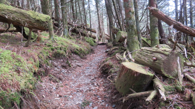
Somewhere between Mt Guyot and Snakeden Ridge, I passed this lovely section of trail that was bathed in lush green moss. It is reminiscent of Grandfather, Beech and Sterling Mountains. The dark spruce canopy and mist added to the magic.


I stopped to eat lunch at the junction with Snakeden Trail. Then headed down Snakeden. It is a very rocky trail which aggravated my feet. By the time I reached the campground, I had some blisters forming.


I walked to the beginning of the Cosby entrance road and was about to hitchhike on Rt 32 to either my truck at Big Creek or the nearest lodge in the other direction. I met a couple walking their dogs and asked if they thought I would get a ride to Big Creek or was better off heading the other direction. The big fellow with full beard said he'd take me after walking the dogs. So I got to spent about 30 minutes with Alaska Tom and hear his story of living in a cabin north of Fairbanks with no electricity and no running water. 


The section of trail from Icewater to Tricorner is among the most spectacular I have hiked. I would love to do it again.

Wednesday, October 30, 2019

Oct 28 Lost in the Uwharries


Yes, even Uwharrie masters get lost. West Morris is a bit confusing to begin with, and I was not paying attention. Beginning at West Morris, my plan was to hike a 7.3 mile route described by Don Childrey in his Uwharrie Lakes Region Trail Guide, utilizing the Uwharrie Trail, Morris Mountain Rd and Panther Branch Rd. It looked nice on paper, simple, straight forward. So, when I saw the bridge over Spencer Creek (pictured above), I knew I had gone the wrong way on the Uwharrie Trail. How did that happen? I just wasn't paying attention at all those intersections back at West Morris. 


Rather than go back, I decide to proceed on, knowing that when I get to Rt 109, I can turn left and walk a quarter mile on the road to the Spencer Creek Rd. That is what I did. The gate across Spencer Creek Rd was open. I walked on a nice graveled road with sides recently bush-hogged. At a half mile, there is a parking area and the road is more of a dirt road with puddles. That lasted for about a half mile. At that point, trees were across the road and trees were growing in the road.  


There is a sizeable mining complex of pits here. Lots of pushed up dirt, littered with quartz. The road turns into a single track and fords a creek. On the other side, I reach the junction with Morris Mountain Rd, or trail as the sign below indicates. If I turn left, I'll be at Spencer Creek bridge in a matter of minutes. Not wanting my adventure to conclude so soon, I turn right to take Morris Mountain Rd to Barnes Creek Overlook Rd. That sounded easy and looked easy on the map.


All went well until I ran into posted property owned by Uncle Jim's Sportsmen Club. Not wishing to cross private property during deer season, I followed the boundary around the property thinking I'd see the other end of Morris Mountain Rd. It was a bit of a detour and then I found a road about where I thought I would. Following it, I seemed to be heading in a direction headed east and not north. So, when I reached an intersection, I turned left and eventually headed west. But wait, I'm on private property again. 


I worked my way in the direction I thought I should be going and ended up in the impact zone of this deer stand with door and sliding windows. It was on the top of a mountain so I tried to download a map. No dice. Neverthless, I starting tracking my route on geotracker. Even without a map, I wanted to see that I was going west and not circling back on myself. About a mile later, I found a timber road and followed it. Then I came to a 3 way junction. I'm completely at a loss which way to go. I turn right and end up a few minutes later on the UT and can make my way back to West Morris. Whew.


Sunday, October 27, 2019

Oct 25 Three Sisters Ridge to Orrell Road


One of my favorite off trail hikes involves Hanging Rock Ridge or Three Sisters Ridge as it is sometimes referred to. There is a well worn trail to the top of Hanging Rock. That is the start of our hike today. Our group of 5 hikes this trail almost to the top. We step off and head out the ridge. Wes reveals it is his first time off trail. The rest of us are in familiar territory. After the first rock is climbed, we find our way to the keyhole and then to the cantilevered rock which has a fire pit. I am dismayed to see graffiti on the rocks here. It is fresh and still has some gloss to it. There is quite a bit here. We clamor through the underbrush to the cave pictured above. This is a rather substantial cave with a huge vulture nest. 
  

From the north side of the ridge, we have a nice view of the Blue Ridge and beyond. The photo shows the view toward Moores Knob.

It is a long gradual walk down off Hanging Rock to the gap with the First Sister. The Sisters look big but they are easily climbed. We go up and down over all three. There is a significant gap between Middle and Third Sister making me wonder if we topped all 3 and I miscounted. Then we head down some more and try to locate Sheep Rock. I have GeoTracker on so we do not stray onto private property.


We think we are on Sheep Rock and settle down for a lunch break. From this point, I can make out the Mill Creek valley and watershed. I can't see Orrell Road but have a good idea where it is. It is our destination and we have a car staged there for the ride back to the Visitor Center. 


After lunch, we continue walking down the ridge in a easterly direction. I know we will run out of state park property if we continue this. So at the first good looking opportunity, we bear right and down more steeply. I sense that we are in the area where I've been before. It has that feel and after a few minutes we find an old timber road with a stone wall alongside. I know I have been there before. We follow it in the direction of Orrell Road. Eventually, it comes to an old tobacco barn which I recognize. 


From there it is just a matter of walking through a couple fields. Mill Creek is low and we decide to rock hop it. None of us make it without a splash in the water. I thought we were through with the creek but alas, we must cross it again. We all had another splash here. 

After piling in the car, we drove up Orrell Rd for a little tour of the new Hanging Rock property. 

Oct 23 Russell Mine


Its one of the shortest hikes you can take in the Uwharries but it is packed with cool stuff. You won't find this on any maps of the Uwharries. The Forest Service doesn't promote this place. They have had to bar off several mine shafts and put up an extensive metal barrier around much of the site.  


The shafts are cool (ha) but the real attraction for me is this massive stone structure which I am told was the Russell Mine Company. On this visit, it appears someone has been doing an arch survey. Perhaps the structure and roads leading to it are being surveyed to understand what went on here.


A rock outcrop here has been pretty thoroughly excavated. There are at least 3 shafts leading under it. They are all barred off now. Shinning a flashlight into them does not reveal much.


I took this photo from well above the shaft opening. It is in a steep gorge. 


This shaft has been barred off for years. It is the first thing you see after rock hopping across the creek. There is a old roadway passing right by it.


This one you can walk in. I took the photo from a collapsed portion. It would have originally been about 60 feet.

Saturday, October 26, 2019

Oct 21 Hanging Rock - Orrell Road


Beginning at Orrell Rd and heading along Mill Creek, then through some fields on an old road. At the first tobacco barn, head up on an old timber road until it peters out. At this point, look for anyway to head up. Deep drainage galleys make it difficult. It becomes really steep but I manage to pop out on top - probably between Middle and Little Sister.


Heading west on the ridge, I look for the first place to head down that is not a drop off. One presents itself and the way down is quite slow and deliberate. A couple of butt slides were needed. After 15 minutes, the terrain leveled out so you could walk without the constant fear of falling. 


I followed the first old road I encountered. It appeared to parallel Orrell Rd. So I ended up right back where I had started.


A walk up Orrell Road was in order at this point. There are a half dozen dilapidated buildings. It is not wise venturing in several since they look as if they could easily collapse. I suspect most will have to be demolished by the park before this area is added to the park map. 


There are sizable dumps here as well. Lots of rusting farm equipment mixed with old household rust - bedsprings, appliances etc. 


Must have been the farmhouse


Apr 24 Riles Creek Paddle

  Riles Creek drains into Tuckertown Reservoir. Today's paddle was organized by Crystal and most of these Photos were taken with her zoo...