Monday, December 17, 2012

L.O.S.T again


L.O.S.T. is Lower Old Scramblers' Trail on the western side of Linville Gorge. Once again, Marshall has meticulously organized our outing on this spectacular route along the the bluffs. Jenny "the blogger" Bennett from Sylva joins Marshall, Dale, Will, Gary and myself for the scramble today. Leaving Jenny's vehicle at Pinch In parking area, we make the bumpy ride up the Kistler Highway to Conley Cove parking area. A short distance down the Conley Cove trail, we follow a well defined path to a large cave, pictured above. Conley Cave appears to be a popular place with several fire rings located in it. One is directly below the crack in the middle of the cave roof, clearly seen above. It looks as though this might serve as a chimney. Along one wall, several spots have been terraced to proved level areas, presumably for sleeping.


From the cave we follow faint trails which have seen some recent maintenance activity. Our route visits Fern Point, Hacker's Point and Blue Jay Point before sliding down a small chute to see One Bat Cave. This cave is smaller than than Conley, perhaps only 30 yards deep but just a few feet wide. Shining my flashlight up, I spot a shaft with light coming through. It appears an animal has built a nest there.

From One Bat Cave, we begin to thrash a bit in the brush, searching for routes. We need to be mindful of where we are. We need to find a long steep chute. Above, Jenny and Marshall cling and slide. Now we're at the base of a rock bluff. It is short distance to Little Seneca one of the highlights of the day.


To pass through here you must use the keyhole shown above. This area has massive rocks piled up under an overhang. It appears something has built nests in the crevices.


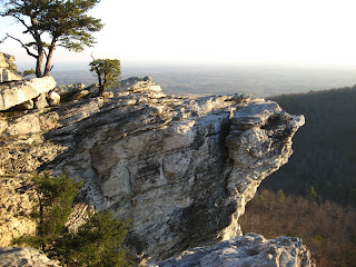
Above, our lunch stop is atop this rock jutting out. It is an impressive view. You can't book a table in a restaurant with this view. The walk out on this rock is a bit unnerving. As is normally the case, not everyone is comfortable with this.


Following lunch we begin the climb up Zen Canyon. This is not a technical climb but can be exhausting. Its a jumble of rocks but there are many handholds. Many of these handholds are small rhododendrons. Jenny advised me later it was considered "poor form" in the climbing world to use a "vegetable hold". Above is the Weeping Wall of Zen Canyon.


Looking back down Zen Canyon at my mates, Will is wondering when this will end. That was the easy part. Now we must steeply scramble up in some brush using multiple vegetable holds. Will and I take a wrong turn  here and get really bogged down in deadfall and briers. Soon we are reunited for a quick respite at Zen Point. Here you can look down on Razors Edge Rock our next destination.


Will and I decide to head out to Razors Edge Rock while the others visit Razor Point. Above is the narrow route out to Razor's Edge Rock. Below Marshall and Jenny peer down on us.


Once down the chute and out the narrow ledge to Razor's Edge Rock, you have to do a couple short climbs. They aren't terribly difficult but a slip here would not end well, so again a couple of our group stay put.


This is one of my favorite spots in the gorge. You seem suspended out in the gorge, able to see the rock bluffs behind you as well as the giant bluffs across the gorge. We can see folks camped on the opposite side. they are just specks. 


The views upriver are spectacular. It is easy to make out the iconic ridgeline of the east side.


Atop the rocks on Razor's Edge, Jenny and Will admire the view. After climbing up here I felt just a little shaky. The moving clouds seem to make the rock bluffs move so like Will, I preferred to sit.

Leaving this area we made out way back to Rock Jock Trail and headed out. The hike out is about an hour and half and passes several other points but we visit only two, Sunshine point and Balanced Rock. The last half hour is up steep trail and it takes its toll on us. I am quite winded at the top.

We covered a lot of interesting territory today. The weather was near perfect for this type outing. I normally come home with some gorge souvenirs in the form of scratches but not today. My tire did pick up a piece of metal  at some point and resulted in complete flat, but not until I was safely home.


Dec 13 Flat Shoals Mountain


Although Flat Shoals Mountain is almost fully within Hanging Rock State Park, it is barely visited. Attached by a narrow corridor crossing Mountain Road, it is accessible only in a couple spots by parking on road shoulders. The easiest access is along Young Road where the park property is adjacent to the road for about 200 yards. There is a wide shoulder on the opposite of the road. The state park side is narrow but if careful, one can park there. The best route up the mountain is almost straight up, heading slightly right to follow a slight spine. A friend told me to look for a couple upturned stones on top which looked like gravestones. That is exactly where I attained the top and a good landmark to use to head back down. 


Once on top you have the option of going either right or left along the top ridgeline. I went right or east. After a short climb I reached a rock jumble on the south facing slope. After poking around for a few minutes I spotted a cave which you could step into but I did not. Following the ridge further is a smaller rock jumble and then the ridge heads down to a gap and rises again to a lower pine covered point. Knowing that the state park property might not extend to that point I chose not to expend the energy needed to go down and up a couple steep slopes. Turning around I retraced back to the gravestones and to the other, westernmost end of the ridge. The ridge was a gradual downward trajectory and then seemed to drop off more steeply. There were some limited winter views here to the west. 

The ridge I had walked was under a mile in length. The south slope had more outcroppings but the views were not nearly as nice as those looking north. I had a unique view of Sauratown Mountain and its rock bluffs, followed by Cook's Wall, the Moore's Knob, Hanging Rock, Hanging Rock Ridge, the Three Sisters and finally Sheep Rock. Again these were limited winter views. I suspect you'd see none of this in the summer.


I returned to first rock jumble I had encountered to poke around further. It appears there a numerous caves here. I found three you could get into. All are pictured here. Small caves you need to squeeze and slither into are not what I'm looking to do so they all remained unexplored today. Walking through this area was difficult. I could not tell what lay underneath the freshly fallen leaves. There were loose rocks, holes and many places to lose your balance. Rest assured when you did lose your balance there is a devils walking stick nearby to grab onto. I think I made that mistake three times.

Using my GPS, I headed down the mountain here rather than climb back up and walk back to the gravestones. The outcropping continues down the mountain for a ways before ending. My GPS indicated I needed to head into the laurel to get back to the car. It looked thick but I found a very nice passage through it which looked like it was a well traveled deer route.

Dec 6 Pizza


Sticking to my favored recipe of half white and half whole wheat flour, I used finely ground whole wheat flour this time. That gave the crust a texture I didn't like as much as the coarsely ground hard red whole wheat flour I've used before. Also, too much dough here made the middle portion gooey. So next time it is back to my favored flours and stretch that dough out in the pan.


Dec 6 Hanging Rock & Sheeprock Ridges


Approaching Hanging Rock State Park from the north, as most folks do, the profile of Hanging Rock dominates. I'm referring to the namesake bluff which overlooks the visitor center. A 1930's era map referred to it as "Hanging Bluff". Hiking up the trail, you reach a point at which you are directly below a piece of the bluff jutting out. This "hanging rock" or "bluff" if you prefer, is quite impressive. The trail to the top navigates along and up the south slope of the ridge. From here you approach the top off "hanging rock" along a spine, from the east. At the point you reverse direction to head out to the west onto Hanging Rock, look to the right for a faint trail in the opposite direction. The trail is distinct here but dissipates quickly once you run into a rock outcropping. After that point there are faint manways here and there but much of the time you are simply looking for the easiest route. Follow the very top of the spine for the best route. You can find expansive views to the South and to the North along here. The Hanging Rock Ridge continues until the ridge drops off in a long gently sloping manner to a gap and then heads back up to the westernmost of the Three Sisters.


This is the highest sister. From here the gap to the middle sister is an easy stroll in open forest. It is here I spotted the bear scat above. Middle Sister is best approached from the highest point in the gap, straight up. From here the going gets tougher. The walk down to the next gap is longer and steeper but again, follow the highest point of the ridge. This easternmost sister has a long gentle slope to the east ending at Sheep Rock. There are some nice rock outcropping here with views East and South. All along the ridge you have nice views of Flat Shoals Mountain and some of the homes along Mountain Road in the valley between the two ridges (Hanging Rock and Flat Shoals).


Tuesday, December 4, 2012

Dec 1 NC Wall Linville Gorge


The scramble today is the NC Wall route. Beginning at Table Rock we follow the MST around the chimney and exit the trail at the climbers' route down the Mossy Monster through the Separation Crack. The route down to the crack was a bit spooky. It was wet and some of the rock holds weren't solid. Fortunately, the rest of the route was dry. Once down the Mossy Monster, we traveled south along the wall. The deadfall and briers were manageable as there was a faint trail through here. 


The trail, if one can call it that, seems to end at the point above. In order to proceed along the wall base, one must either climb this tree or scramble over the rock just a bit further from the tree. Most of us went up the rock. I had some difficulty here and needed to memorize where the footholds were since once you began, you could not longer see them. The tree is still a viable way to go but the branch supported by the rock has died and may at some point break off. That would render this method much more difficult.


The going beyond here is rougher. I needed to snip myself free from briers many times. Our route heads toward the Sphinx rock formation. The climb up the Sphinx was a bit too daunting for two of our party, so most of us ate lunch atop this rock while two remained slightly below. 


Gerri picks out a great seat for lunch.


John does a bit of exploring on the Sphinx and refers me to this flower below. I think this is Pink Punctatum, Carolina Rhododendron. I am thrilled to see it blooming here in December.


After lunch, we climb off the Sphinx and continue along the wall and head up a gully into the Amphitheater. This gully is not terribly difficult in terms of being technical but it can be exhausting. I am worn out after the scramble up.


Some of us continue to the Mummy. I stop at a spot overlooking the Mummy while 5 go below to explore. The views here are nice and I have a relaxing rest.


The day is not done. We must hike up the side of the gorge a long way to the MST. This is another exhausting climb. Finally, we walk on trail again. The final scramble of the day is a traverse of the chimneys. 
The view from the top of the chimneys is 360 degrees. You can easily make out the balds on Roan Mountain to the north. We make our way over the chimneys and exit down the climbers' gully onto the MST for the final walk to Table Rock.


Nov 29 Hanging Rock


Tonight our group, Friends of Sauratown Mountains is meeting at the hanging Rock Rock State Park Visitors Center for our annual meeting. Former Hanging Rock SP superintendent, Dave Cook is presently a program entitled "The best of Hanging Rock you have never seen". Dave has spent much free and official time roaming the off trail areas of the park exploring. His program highlighted many caves, waterfalls, Cascade Gorge, Huckleberry Ridge, Flat Shoals Mountain, the Three Sisters and other interesting spots. 

There is a lot to explore at Hanging Rock. Prior to the meeting I hiked up Hanging Rock and relaxed. These are a couple shots I took while there.


Two spots which caught my attention during Dave's Program were the May 1963 plane crash on one of the sisters and the relativity large cave in Hanging Rock (in the namesake rock). Hopefully I'll be highlighting them in a blog soon.

Nov 29 Uwharrie Trail Update


Prickly Pear Cactus on Little Long Mountain

The Land Trust for Central North Carolina has been spearheading a effort to reconnect the original Uwharrie Trail as constructed back in the 1960's by Joe Moffitt and others. Today the Uwharrie Trail Committee met in the Ophir community to discuss and update our activities and plans.

Crystal Cockman chaired the meeting and brought everyone up to date on the the current situation. Some years back, the original Uwharrie Trail ran from Tot Hill Road by the now Tot Hill Golf Course to the trail head on Rts 24/27 west of Troy. During the 1980's the trail was shortened to just the section from Rts 24/27 to Dark Mountain (Jumpin Off Rock parking area) on Flint Hill Rd in Ophir. The north part of the trail through the Birkhead Wilderness was re-christened "Birkhead Trail". The section between the two, roughly from the southern boundary of the Birkhead Wilderness to Flint Hill Road was abandoned. Much of that route was on private property or along a road. Some of the land was timbered and the route was obliterated. 

Years later the land trust became involved, piecing together tracts. Actually purchasing land and re-routing trail on Forest Service property. Now, we are close to re-connecting everything with just a few obstacles. Much of the original route north from Flint Hill Road has been re-blazed to Little Long Mountain. From Little Long Mountain into Randolph County, two routes have been identified to King Mountain. From King Mountain, there is some route identified and some re-route necessary. From High Pine Church Road to the southern wilderness boundary is still one of the obstacles.

Although, this sounds like we have trail through this area, there is still much work to be done. Some of the route is not desirable and needs to re-routed. That is the focus of my attention. After several scouting forays here and there, I still have work to do. It seems all the easy stuff has been done to this point and now the work looks more daunting. 

In addition to the current status and future trail route ideas, Crystal covered a number of related topic at the meeting. The committee would like to document more of the effort Joe Moffitt put into this trail and honor him in some way. Some grant monies can be used for some trail enhancements. One idea is to use grant money for a series of trail posts with QR codes. QR codes are the bar code like patterns recognized by smart phones. When accessed, an application can tell a story, show pictures or play a recorded message on a handheld device. 

After the meeting a field trip was organized to Little Long Mountain. Crystal spoke of a possible controlled burn on the mountain. The top is the only 360 degree view along the trail. With sumac and salt bushes growing like weeds, that view is now limited. 

We also scouted a possible re-route. The existing trail is along old road which are terrible eroded. Walking along them in wet conditions is really undesirable. 


Salt Bush on Little Long Mountain

Nov 17 Linville Gorge scramble


Top Linville Gorge instigator, Marshall, formulated the plan today. It was to be a route not done by anyone in our small group of 4. Beginning at Table Rock heading south on the MST, we travel a short way to the view above and then to the view of the Camel below. It is about here the fun begins. The is a gully just to the north of the Camel and Apricot Wall. That is our route down.


Once at the base of the wall, we follow a faint climbers route along the base to a point between Apricot Wall and the Camel. Briefly we consider circumnavigating the camel or climbing it. Those don't look like good or fun options. We continue to travel along the base of the Apricot, exploring some caves we see about 15 to 20 feet up the wall but still accessible. 


The going gets thorny here, greenbrier thrives in the area. Lunch is on a ledge along the base of Apricot. We encounter some climbers on the wall near here. We see them most of the rest of the afternoon making their way up the south facing wall of the Apricot. 

Matt spots a 5 petal white flower blooming in several spots. It turns out to be a variation of Mountain Sandwort - Greenland Sandwort. Later in the week, some gals with the NC DNR tell us there is one patch of this stuff in Burke County last spotted in 1982.


The afternoon is filled with navigation through dead-fall and greenbrier. After a nasty bout this tandem, we reach a rock formation and climb it to catch our breath. Marshall says we have only another  100 feet or so (I've learned "or so" is a vague and nebulous expression with a meaning somewhere between "no clue and rough hypothesis"). From our perch we can see a tangle of briers below. Ben heads straight up the wall in what the rest of us are convinced is a foolhardy but entertaining attempt to shorten our route. He disappears in the rhododendron and occasionally yells back at us. To our surprise he has successfully navigated around to the upper end of the separation crack, thus bypassing the Mossy Monster. This is good news and the rest of us scramble up this route and are forced to feed Ben's ego the rest of the day. The picture above is the upper end of the separation crack. Technically this is not a crack, it is a very narrow space between a wall and a spire.  


Matt is all smiles not realizing there is a lot of air under him.


We trudge up the side of the gorge to the MST. At this point on the MST there are some short trails eastward to lookouts. Most of these afford nice views of a rock formation, The Castle.

Marshall has planned a return route over the Chimneys. This turns out to be an exciting adventure with some spooky scrambling and outstanding views. We manage to traverse the entire area but don't feel comfortable descending the rocks of the northeast end. Some climbers direct to a gully they use to access the top. This is an easy route down.


A great view of Shortoff and south

Nov 11 Black River


Again this morning the water was so still you could see a perfect reflection in the water. After leaving the campsite and heading downriver there is a cove on river right. Coves are bodies of water that likely were river at one time but have been blocked. Often when you encounter one, it is not clear which way the river goes and which is a dead end cove. This is one of those spots. You can carefully watch the water and floating leaves to see which way the river current flows but a slight breeze can deceive. At this point Will and I were paddling far enough apart we went in opposite directions at this junction. Fortunately it does not take long to realize your mistake.


Above is a small cove with a small island of cypress. Directly beyond the island is firm ground. Although not apparent here, there is a dirt road very close to the water here on Cone Folly property.


I stopped at this spot to look for cypress cones. Cypress seeds are in a small, acorn sized cone. The cone usually drops into the water and is carried downriver. An interesting path to life.

As we near our take out spot, the river widens and narrows. We reach a junction with another cove and decide to follow the river left course. After a minutes we see the water current is definitely against us. So, we turn around and head back to the junction. Nothing looks right. Will is going to check out the course to river right and I am to hail any passing boats. A boat does come along and we learn we were going in the proper direction all along. The current was against us because the river is tidal at this point. We are a long way from the ocean but apparently still within its influence. We paddle against the tide and reach our take out spot. 

Friday, November 30, 2012

Nov 10 Three Sisters Swamp


We're ready for our big day in the swamp, packing the boats up here almost ready to push off. The water is completely still and you can see a perfect reflection in the black water.


All morning we paddle along a river that widens and narrows many times. There are spots where motor boats can operate and places where we barely skim past the sand below. There is one bridge we pass under. We use this opportunity to explore on the blacktop a bit. An old, abandoned home mesmerizes us. Will thinks he recognizes the house from a movie. It is movie worthy of a beautiful old (maybe 100 yrs) structure on high ground riverside with just a faint lightly used two track driveway. 

We slip the boats back into the black water and continue downriver. This next section is not scenic. It is straight with a high sandy bank on river left, sporting a pine savannah. Long Leaf Pine is the dominate tree here. We pass a private boat ramp from which some kayakers use as a starting point through the Three Sisters Swamp. The river becomes a bit more interesting. It is more serpentine, narrow and shallow. Will is armed with directions from master canoeist and guidebook author Paul Ferguson.   We are supposed to look for channels going off into the swamp on river right. At this point it is counter-intuitive, but we are to head off into the swamp instead of following the well defined river. We find such a place and pause. It matches the description and is counter-intuitive. We just sorta shrug and decide to go for it. Immediately we are in maze of narrow channels going different ways. It is a bit intense at first wondering if we are headed into a unpenetrable area. We spend much time looking things over before proceeding. Most of the time we are hung up on a fallen log or too wide to fit between some knees. We are careful not to lose sight of one another. It is very easy to do here. Probably 15 minutes into this swamp session we finally come around and realize we will make it through and we should be checking out the amazing place we are in. It is here the oldest trees east of Rockies reside. BLK 069 as it is known, was core dated to 364 AD. And that was 12-15 feet up from the base. Cypress trees have immense bases, so cores have to be done higher up. There are larger trees than BLK 069 but core samples showed a condition known as heart rot in which the center of the tree rots first and can not be dated.


The Nature Conservancy owns a portion of this swamp and many of the monster trees. The trees grow to a certain height and then seem to grow only in girth. Some are huge at the top and have equally large branches. Like other old thing, they are gnarled and missing tops and limbs. Spanish moss adorns everyone. The knees are unbelievable large, some 7 feet or more in height.


The total paddling distance through here is probably only 3/4 of a mile. The first 1/4 mile was the most difficult. As we worked our way further in, the channels became larger with fewer obstacles. The water level is quite low. It was below the estimated minimum flow needed according to the Ferguson guide. We did have get out of the boats on a couple occasions to pull them over or through something. Will sunk to his knee in sand during one drag. When we found a place to stop and get on firm ground it wasn't quite a firm as it looked. It was easy to sink in 6 inches or so every step if you weren't careful.


Back in the boats we exit the swamp back into well defined river. At this point you can see 3 distinct channels emerging from the swamp to form one river. Looking at an aerial of the swamp you'll see this also. I'm told that is how the name "Three Sisters" was derived. 


Once through the swamp, we begin the search for a suitable campsite. River right is a mass of cypress and knees with no good ground. River left is Cone's Folly owned by Ben Cone of Greensboro. It is well posted and we were sufficiently warned a caretaker patrols it and is never lenient. We saw many suitable spots on the Cone side but each seemed to have more posted signs than the last. We finally stop at a spot on Cone's side. We would have to drag boats over a berm and then camp out of sight. I wasn't comfortable with the situation. Will said he had met Ben Cone once. Will was a mentor of sorts to Ben for a day but Ben probably doesn't remember and Will's phone calls to him went unanswered. We decide to check a little further downriver and paddle back if needed. Will finds a great spot with a wide sandbar just downriver on river right so that is where we camp.


Once set up, I paddled into a cove nearby, surrounded by Cone's Folly on 3 sides. There were a couple monsters (trees) here and some big knees. I also managed to find a nice spot to land and checked out a pine savannah just across the river from our camp. It was a 10 foot bluff so no cypress grew here.


Check out the red tea color of the water above.


This knee is about 6 feet high.


Once again we had a nice campfire. It was dark by 5:30 so it was an early fire too. After a long day I was ready to crawl into the dome early. Sleep came quickly but just as quickly I was awakened by some pesky nocturnal creature. I got up and something ran off which sounded like a deer. Again it was back to sleep. Again, pesky nocturnal creature #2 wakes me. I'm up shinning the light about and spot the bear on the bluff across the river. It just stared back at me as if in a Mexican standoff. Finally it turned and lumbered through the brush. I felt fine, after all there was a river between us. Will pointed out the next morning that river would be nothing to that bear. The river is maybe 50 feet wide and maybe 18 inches deep at its deepest.

Twice more I am awakened by the bear. Once it was making the normal bear sound - a cross between a growl and labored breathing. That time the bear ran off at full speed crashing through the woods, snapping fallen branches as it went. The final time the bear made an odd noise I learned later was a sign of anxiety. It sounded like 2 heavy breaths and then a contented "hmmmmmmm". At this point I figured I never get any sleep but I grew tired of the standoff, crawled in the dome and fell right to sleep, not to wake until daybreak. 

Nov 19 Quechee Gorge

  At 165 feet deep, Quechee Gorge is the deepest gorge in Vermont. The Ottauquechee River flows through it. The name is derived from a Natic...