Tuesday, July 24, 2018

July 20 Feeder Canal Trail at Glens Falls


At Glens Falls New York, the Hudson River drops twice in what were picturesque waterfalls. Today they both are incorporated into dams. Initially, the feeder canal was not used for navigation around the falls. Its purpose was to channel water into the Champlain Canal. At the same time the Erie Canal was built, 1817-1823, the Champlain Canal was constructed. It connected the Hudson River at Fort Edwards, 60 miles to Lake Champlain. As an afterthought, the Feeder Canal was enlarged for navigation, allowing barges to travel further up the Hudson, bypassing the falls.


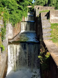
As the feeder canal approached the Champlain Canal, it steeply descended. It was a sizable engineering feat to put together a series of 8 or 9 deep locks to negotiate the terrain.  


There are many faces of the Feeder Canal. The impressive series of locks is one. At other times the opposite side abuts building and many backyards. At a couple other points factory buildings squeeze you right to the brink of the towpath. As downtown Glens Falls is approached, the original canal bed is obliterated by a paper company.


The ride along the Feeder canal is paved but once at the Champlain Canal, the trail is cinder. I rode the canal in its entirety and a short section of the Champlain Canal, about 20 mile total.

July 9 American Tobacco Trail


I got an early start on the bike ride. It was to heat up later but I could get in a nice 30 mile ride before the heat set upon me.Normally, I would not post an entry for a ride like this but I encountered so much new construction along the trail, I decided to give this update.


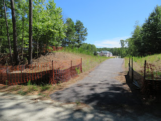
A very large housing development is being constructed here in the mid section, Chatham County section. So large, it requires a short lighted tunnel seen above.


access trails are being put in at two other spots in that same housing development.


Further south, between Hwy 64 and the New Hope trailhead, another massive development is underway, encompassing both sides of the trail.


July 7 Grays Lilies on Roan Mountain


Grays Lilies are found here and no where else. It has been several years since I last visited them so it was time to pay a visit. Beginning at Carvers Gap, mist threatening, we made our way uphill on the AT. We had to walk a good distance before encountering the fist group, a pitifully small example. We pushed on over several balds to the junction with Grassy Ridge Bald. After seeing a number of Lilies, we turned back to the gap.


Still with some time to hike, we drove to Hughes Gap and hiked the AT south, uphill for a couple miles to a nice overlook. The view appeared and disappeared as the clouds made their way through the mountains. It was along this section we saw a healthy crop of Efts, like this fellow below.


June 28 Little River Paddle


Last nights paddle on the Little River was cancelled due to some ugly thunderstorms in the area. So we left the Kayaks ready to go today. The paddle is a short out and back in the backwater of a dam further downstream. We begin the paddle at a put in provided by the city of Troy on Pekin Road. There is a crowd of young folks paddling and fishing here. We get the boats in the water and begin paddling upriver. Our turn around spot is the old Capelsie mill on Capelsie Road.


We see the overgrown mill and hear the roar of the dam. The river narrows and we have to navigate through a maze of rocks in quick water. The effort is finally abandoned a couple hundred yards from the dam and we wade the remaining distance. The large rock dam looks like it may have supported a bridge atop it. We can see one buttress at the dam's midpoint.


Hidden in the forest growth is the old brick mill building.


On the return we take a closer look at a gorgeous home riverside. Crystal mentioned to me who lived there but now I don't recall. Nearby is this sunken speedboat. I suppose it will make its way further downriver in some high water event.


The Pekin Road bridge looms ahead and signals the end of the paddle. It has warmed up significantly, so I am glad to free myself from the confines of the kayak.

June 21 Gregory Bald


The weather forecast is rain at some time today. It looks like it might not come until I am on the way down, so it is a go for the Gregory Ridge Trail. Overcast skies make for a very humid day even though the temperature is not excessive. Perspiration drips from me almost the entire way. The trail levels for a bit just prior to reaching the Gregory Bald Trail.


Once at the bald, the azalea colors dazzle but my photos show a drop of moisture on the camera lens. So many of my photos have a blurry spot strategically placed in the center. Even with that blurry spot, I am posting these photos to show the range of colors encountered.


Downhill was easier but temperatures poked up a bit. Just minutes after arriving at the trailhead, the forecast rain makes its appearance.


Tuesday, July 10, 2018

June 19 Clingman's Dome Tower


It is quite an impressive structure that sits atop Clingmans Dome. The mountain is the second highest peak in the eastern US, the highest point in the Smokies and highest point on the Appalachian Trail. However, as you can see, it is quite accessible to most folks. There is a half mile long paved, albeit steep, trail from a parking area at the end of a 7 mile spur road off the main thoroughfare through the park. The spur was originally to be a thoroughfare through the park also but got nixed before it could be built in its entirety. 


The concrete structure we see today was built in 1958-9. It was part of a NPS program to improve observation towers throughout its system. The previous tower was a of log construction and had a must greater rustic look. Over time the logs deteriorated to the point the tower had to be closed. A contest or bidding process settled on the design of Hubert Bebb, a local Gatlinburg architect. His design originally had a stone tower with circular platform and a fire observation cabin. It did include the iconic ramp. The stones and the cabin were rejected and the ramp was debated but remained. 


In 2016, Partners in Preservation held a nationwide contest to receive funding for park projects. Friends of the Smokies applied for a grant to make needed repairs to the tower. Voting by the public determined the winners. The Friends were successful in securing a $250,000 grant to make repairs to the walls, supports, masonry and ramp surface, Most of those repairs were completed by June of this year. One more closure is needed to complete the work. 


Nov 19 Quechee Gorge

  At 165 feet deep, Quechee Gorge is the deepest gorge in Vermont. The Ottauquechee River flows through it. The name is derived from a Natic...