The main flat rock
A warm end to winter brings those early spring blooms out earlier. The parade of flowers at Forty Acre Rock has begun. With no particular plan in mind, I left the lower parking area about 10am in clear 65 degree weather. Some rocks off trail caught my eye about 10 minutes into the hike. The next four images are a sampling of the boulders I encountered in this off trail jaunt.
Very similar to the boulders we have encountered on the other side of Nature Reserve Road, these seem more concentrated in a smaller area. Upon reaching the powerline which bisects the Nature Preserve, a decision was needed. I was eye level with the wire themselves and could see rocks on the other side of the cut also at eye level. However, to get across the power line cut required a steep descent and then a rock climb which did not appeal to me. I made my way to the powerline cut at a higher spot and followed the cut out to the trail I had started on.
In just a few minutes I was at the base of the main rock and Naked Falls Waterslide. Trout Lilies were abundant with a number already blooming. The water from this waterfall comes off the main rock above. A short distance below the waterfall, the water enters a larger but still small creek which drains the ancillary flat rocks and Cambridge Falls. Climbing up beside the waterslide reveals a narrow channel in a rock cut above. The water races through here on its way to the waterslide.
While doing some trail building during the past year, there were many Trout Lilies which came up in the trail about this time of year. Thinking I could dig a few out of the trail and transplant them, I learned they have tiny bulb shaped like a tooth, The bulb is attached to a root resembling a string several inches long. The bulb can be inches below the surface, generally the length of the flower stem. All that made it quite difficult to transplant and take hold again. Normally, when you see one, you see hundreds if not thousands. These beds must take a long time to develop.
The waterslide at Naked Falls
Now, it is on to the main rock. Almost every description of Forty Acre Rock is quick to point out the rock is 14 acres in size. Of course that is the surface size above ground.
Enlarging this photo will reveal pry marks on the rock. Apparently, some of the rock was quarried at one time.
Vibrant moss with a Bluet
One of the first mentions of Forty Acre Rock dates to 1843 when William Gilmore Simms, famous SC author, referred to the place as "Flat Rock". He commented that the circular depressions like this one, were carved by Native Americans to grind corn. Growing up in Connecticut, I saw a rock with a much smaller depression - about the size of a mixing bowl. It was described as a bowl for grinding foods, the modern day blender, then a mortar and pestle. That made a lot more sense then these huge depressions being used for that purpose.
Moss, lichen and Eastern Red Cedars make up the periphery of the rocks before transitioning to hardwood forest.
The highest part of the rock resembles a gorgeous wild garden. What a lovely backyard this would make.
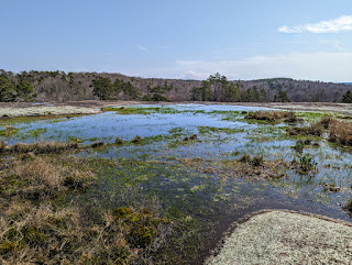
The round depressions come in all sizes. Some are holding water and some just have water when it rains. The amount of water and how long it stays determines how much vegetation will grow in it. With Elf Orpine and Puck Orpine, the wetter the depression, the more vibrantly red the vegetation is.
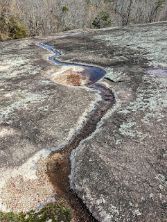
These pools at the high end of the rock, provide a store of water. As the water slowly seeps out of the vegetation and makes its way down, it can fill other pools or cut shallow water paths down the rock surface.
Although, the rock gets its share of vandalism, mostly in the form of paint, this is not graffiti. The two depressions with Elf Orpine look like a pair of sunglasses.
Elf Orpine up close. I did not see any blooming. The next phase is a small white flower atop the red structure. When seeds have fully formed, the plant dies and withers away during the summer. In the fall the seed pods open and spread the seeds for next year's crop.
After leaving the main rock, it is a short hike to a series of other smaller flat rocks. They don't get visited as much but enough so they get some graffiti and campfires. One of my biggest takeaway's from this visit was how fragile some of the vegetation is and how few people visit here. Any uptick in visitation is going to have a detrimental effect, particularly on the ancillary flat rocks. I found myself trying to sidestep moss and lichen but not everyone does that. The shallow bogs that develop, often had pathways cut through them. Unlike many other areas of fragile vegetation, this place has no delineated pathways over the rock surfaces. I'm afraid that will lead to damage and restrictions on visitation.
There is a flat rock far enough removed from the others, that it has escaped much visitation. That would be a good one to close off and fully protect. I did not visit it during this tour.
Please don't love this place to death.
There is a faint pathway leading off from the smaller flat rock complex which leads to some rock. As I approached the rocks, I thought these might be the ones I observed earlier when the powerline cut thwarted my advance. Sure enough these are the same ones I saw from the other side of the powerline.
My lunch stop
The faint trail leads back to a spot I recognize near Naked Falls. That trail leads to Cambridge Falls and the Endless Cave complete with wall to wall graffiti. I was told there was a second cave here. In the images below, it does appear the rock overhang has an opening which could be considered a cave. I have only visited here when there was plenty of water but it has to be dry for long periods during the summer. That would make that cave more accessible.
The cave entrance below Nate's graffiti.
Retracing my steps back to the parking area leads to another trail on the property. A circumnavigation of Beaver Pond is not passable at this time due to a bridge being out. It has been that way for a few years. So, I just walked along part of this path to a nice rock with this nice view. A pair of binoculars would have revealed a lot more here.
Do you want to see Bloodroots? This is the place. A decommissioned section of US 601 and this 1926 bridge over Flat Creek is a huge breeding ground for the showy Bloodroots.
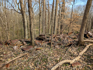
A drain time dump along the old road.
It's 2:30 and the end of my tour. This is one of those places that provides lasting memories. there is so much to see in this incredibly diverse preserve.


