Sunday, January 26, 2025

Jan 24 Pee Dee Wildlife Refuge Birding

Photo by Pierce Foster & Three Rivers Land Trust

Three Rivers Land Trust has been organizing this event for several years now. The Pee Dee National Wildlife Refuge is the winter home for thousands of migrating ducks and other waterfowl. Located on either side of the Pee Dee River downriver from Tillery Dam, the refuge floods cornfields in the fall in anticipation of the arrivals. From 1934 to 1975, the area was a private waterfowl refuge created by Lockhart and Hazel Gaddy. They provided a winter retreat for over 10,000 migrating James Bay Canada geese. Beginning with only 9 geese wintering in 1934, it grew to 10,000 by 1954. In the 1960s the US government began acquiring land in the area for the same purpose. Only a few Canadas winter here now but thousands of Mallards, Woodies and other ducks do visit. 

Back when the Gaddy's operated the refuge, they were surrounded by commercial hunting enterprises. Known as "roast beef of the sky", geese were prized by hunters more then than now. 

Photo by Pierce Foster & Three Rivers Land Trust


As we caravanned out on the levies between flooded fields, ducks became alarmed and rose up from the corn stalks. The last time I visited, once vehicles approached, the ducks took flight and headed elsewhere. Today, the ducks had no place to go due to there not being much open water. So, the ducks flew around and could only see frozen water. Thus, they headed back to the only open water which was where they had started from. We watched as thousands of ducks flew back and forth and finally disappeared back into the corn stalks.  


Photo by Pierce Foster & Three Rivers Land Trust

On the levy

Flooded cornfield

All those small dots are ducks


I could make out some Mallards here but that was about it. I think the smaller ones were Wood ducks. We spent about an hour out on the levies. My feet were numb by that time. The temperature had warmed to about 25 by late morning.

Jan 23 Buffalo Creek Preserve


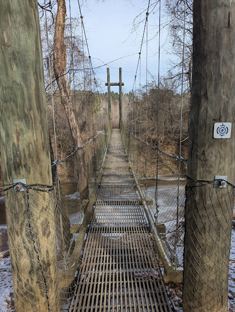
Buffalo Creek Preserve, located near Mount Pleasant, NC, was developed for recreational hiking by the Catawba Lands Conservancy and is part of the Carolina Tread Trail. One would think this wonderful suspension bridge spans Buffalo Creek but it does not. This is Adams Creek which flows into Dutch Buffalo Creek nearby. Dutch Buffalo Creek flows into the Rocky River and then the Pee Dee.

Crossing this bridge with more than one person at a time is a dizzying experience. Here is a video of just me making the crossing.   


The bridge was designed and built by Alpine Towers in Arden NC. They specialize in climbing towers as well as suspension bridges.


This is the largest American holly I've ever seen. It has 5 trunks and towers over the utility lines. 

On the bluffs over Adams Creek

Frozen trail turned to mud by the time I turned around to head back to the trailhead.


Jan 20 Haw River Trail at Longmeadow


Today, we are on the Haw River Trail at Longmeadow, a rather short section of hiking trail that may one day connect with other hiking trails along the Haw River. Our hike today is barely 3 miles out and back. It is very near downtown Graham. Most of the trail is beside a golf course so very few homes were visible. And the golf course was closed due to the weather. As has been the case lately, frozen trail early in the morning, turns to mud by noon. 


Ever since Stanley told me about the big cat in Burlington, I've been looking for prints while in Alamance County. These aren't large enough for that cat and look more like a canine minus nails.


The trail follows the Haw River on river left. Here is the bridge under I-40 and I-85 and then a hiking bridge over a tributary. There is lots of traffic on this road and this is a noisy spot.


The only riffle we saw in an otherwise lazy flowing river.


The sign indicates the end of the trail. However, a bridge says otherwise. Once I walked across it, it's true, this is the end of the trail. The Haw River Trail is a work in progress. The river corridor from Haw River State Park to Jordan Lake State Recreation Area is 80 miles. Of that, about half is paddle able with river accesses. The terrestrial trail is currently about 20 miles. I have been on most of the land trail. This is one of the least scenic segments. 


This is a nicely built single span bridge. I would have been fun to see this being built. 

Chainsaw fun


Saturday, January 25, 2025

Jan 17 East Morris Hike


About a year ago I explored the East Morris area a couple times. This trip I wanted to follow Spencer Creek. Not far from the entrance of Morris Mountain Road off Tower Road, I headed in the direction of Spencer Creek. After a short forest walk, I arrived and began to follow it downstream. Meandering here and there as I went, I crossed a number of times to check out anything interesting. 

I encountered a large number of pits by the creek in a floodplain. I see pits most places in the Uwharries but usually not floodplains. Possibly these were clay pits.


Not wishing to go all the way to Rt 109, I investigated a bunch of quartz rocks on creek left. These quartz rocks had been dumped here, down a steep embankment. I'm not referring to a small amount of rocks either. There were tons of them. And among them I located the most transparent quartz I've ever encountered. Could these rocks be from the Morris Mountain mine which has eluded me? I followed the road leading up and away from the quartz dump. The road would have been difficult to follow were it not for all the quartz rocks which were in many spots along the road but no where else. Obviously, some quartz never made it to the dump. Up and Up I went, thinking all the time I would find the mine. 


Then this presented itself; Uncle Jim's Hunt Club property, posted to the nth degree. I have stumbled onto this property before but not here. It's populated with fully enclosed deer stands with staircases, windows and other amenities. Not wanting to trespass here, I followed the property line to head back to Tower Road. 


I ended up in the East Morris Mountain Hunt Club. I didn't want to disturb the camp above until I noticed it was abandoned. Someone's pop-up camper didn't close up like it should have, a common problem with them. So, it appears it was just left here. Our wonderful Forest Service has to follow a legal procedure before these abandoned camps can be removed. That is such a pity. 


Now, I'm headed back to my truck, walking along Tower Road. A freshly dozed road appears on the right side of the road. I followed it for a good way, It roughly followed an old road, going through several wildlife fields or food plots as we refer to them. Running out of daylight forced me to change course.


One final time I crossed Spencer creek before returning to Morris Mountain road. 


Jan 16 Randolph County Hike


Bison Burl

My outing today is on undeveloped public land. An effort to develop hiking trails on the property has begun. I wanted to see what was out there. 


Freshwater mussels aren't supposed to be this big.

Loblolly plantation has a wonderfully green carpet of Running cedar


American Holly

Lions mane

Chimney fall

My 1919 map of Randolph County mail routes shows this homesite. Back then, there was a road going past it. That road is barely still there. The homesite was also the location for a timber cut, probably in the 1960s. I found some 1960s era soda bottles and milk bottles tossed aside next to what appeared to be a saw dust pile. Aerial photos of this area indicate loblollies were planted after the timber cut. 

Tire embraces a Loblolly

Gravel bars in creek

An old road

There is that holly again


Jan 15 Ridges Mountain


I've visited this state nature preserve many times. I wanted to see some areas of it I've not been to before. This was not a full tour of the preserve, I concentrated in the areas around the stone corral and NW of the big rocks. I did not enter the area of the big bouldering rocks this trip.

Upon arrival, you can access a hiking sign up form via a QR code on the kiosk. That is much better than calling a phone number that rarely is answered, to obtain permission to enter. Having done that, I immediately headed off to the left following closely to the preserve boundary. I saw an old road here but it entered and exited the property quickly. There were many rocks through here. Not much else except a few mylar balloons.


The next area I wanted to see was the stone corral area. Here there are remnants of a dry stack stone wall that may have enclosed a rather large area, perhaps a bit less than an acre. The stonewall would go for a ways and then end only to be picked up later. I'm told this may have been the area of the Godfrey Ridge's Trading Post and along the Indian trading path. Richard Traunter's memoir of his 1698 trip mentions a very rocky hill along the trading path about 3 miles from the Keyauwee Indian Village. So, maybe the path did go through the big boulders of Ridge's Mountain. If so, it may have been a special place or resource location for the Indians. Otherwise, the trading path could have easily stayed below in the bottomlands along Caraway Creek and avoided the rocky way through here. 


Very close to the stone corral, you can see a couple deer stands on adjacent property. There is also a rather large stone free area here. Within the stone corral and adjacent to it, the land appears to have been cleared of stones. I found what could have been a stone foundation in this vicinity. 

Relatively rock free area near stone corral 

Stone corral area near property line

Former deer stand

Another balanced rock


This reminds me of those thick pastrami sandwiches from Katz Deli

Deer stand in stone corral area


Deer stand, not an outhouse.

Stone corral area


I wrote that I did not enter the large rocks area. The above complex is near that area but sloping downhill to the northwest. There are not any social trails through here so you need to be mindful to not step onto a pile of loose leaves with a hole beneath them. Ouch.


Jan 28 Rainbow Falls

  This was to be my much anticipated return to Mt Cammerer but road conditions and closures due to TS Helene and recent weather prevented an...