Friday, April 21, 2017

Apr 12 Baxter Creek


Today's SWP hike is led by Doris Gove. The planned route is from Big Creek to the firetower and back. The climb up is a massive 4240' in elevation gain. After crossing Big Creek and walking in the shadow of a wall of rock face, we enter some bottomlands. Obviously, inhabited at one time, the area reveals many relics from the recent past. Most notable is the 35' chimney on the banks of Big Creek. The Crestmont Lumber Company built this lodge years ago. The chimney has a mortarless look to it, with rocks jutting out in all directions, as below.


Young, tall and straight Poplar Tuliptrees populate the bottomland.


The first stage of our hike was peppered with wildflower stops. The display was as good as it gets. Purple Phacelia was thicker than I have ever experienced it.

After we made it through the first 2 miles, the trail entered a drier area and the wildflowers were left behind. We did see 2 lone Painted Trilliums here. As the hike wore on, 4 of the the original 10 dropped out. At the 4 mile mark I called it quits. I sat on a Chestnut log and ate a leisurely lunch, watching Teresa and Doris drudge by on there way to the top.


The largest Persimmon Tree I have ever seen.


Yellow Mandarin keeping a Sweet White Trillium company in one of the many rich areas along this trail.


Monday, April 17, 2017

Apr 11 Mount LeConte via Alum Cave Trail


To hike the Alum Cave Trail and park in a real parking spot, you need to begin your outing early as I did. The two parking areas were already filling at 8am. By mid afternoon and my return, parking along the roadway ways getting very creative.

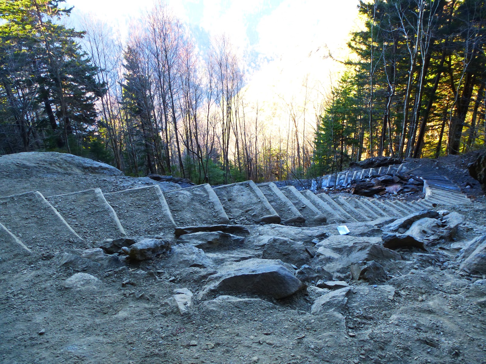
The first 8 photos here, show the recent work of the Trails Forever Trail crew. Funded by the Friends of the Smokies, the Trails Forever endowment fund has raised $5 million for trail work. Already they have worked on the trail from Clingman's Dome parking area to Andrews Bald and Chimney Tops Trail, making them more sustainable trails. Now with the completion of Alum Cave Trail in November, another trail has been added to their accomplishments. Unfortunately, the Chimney Tops Trail will have to remain closed for years following the devastating fire last November. Alum Cave  is one of the most popular trails in the park and has suffered from overuse. A number of areas needed attention. You can see in these photos the wonderful work the trail crew did. The bridge below was rebuilt using two 40 foot long Black Locust stringers hauled up by mules.


The old stone steps going through Arch Rock has been completely reworked as seen above.


The stone staircase is in an eroded area just above Arch Rock.


As you approach the Bluffs, this staircase was built using Black Locust logs, airlifted here.


Previously, when you arrived at the Bluffs, there was a bit of a scramble which began to erode the whole area. This set of steps was also made from Black Locust. There was not sufficient rock in the area to built stone steps. Anakeesta does not lend itself well as a building material because of the way it crumbles in layers.


This staircase is beyond the Bluffs and looks like a staircase to heaven.


As I attain elevation, there is snow on the ground. It was pretty slushy so no ice to worry about today.

Nature's artwork - Is it rock or wood?


The stairway leading down to LeConte Lodge had a bit of snow. Guests had already left and the crew was busy readying the cabins for the next batch of guests.


At the very top of LeConte, 6593'; it is easy to remember that elevation. So many hikers sport the t-shirts sold at the Lodge. "I hiked it" , "Mt LeConte 6593". I turned on my Backcountry Navigator and held it, about 1 foot above ground, and it read 6594'. Pretty accurate! I sat in the pile of Anakeesta at the summit for about 45 minutes. The summit is wooded. It is a beautiful Spruce-Fir forest with a healthy growth of moss and ferns hiding the rocks and fallen trees.


When hiking this trail, you can easily see this arch. It is on a knife edged ridge, Duck Hawk Ridge. Officially this ridge is closed to scramblers. A manway exists to it just beyond the Bluffs. Signs are posted a little in along the walkway. Officially closed because of nesting Peregrine Falcons, I think the falcons have moved on and the park just doesn't deem this place safe for scramblers since it is so enticing. 

Apr 10 Chimneys Picnic Area Blooms

Sweet White Trillium

The Chimneys Picnic Area has always been a hotbed of wildflowers during this time of year. The Chimney Tops 2 fire began not far from here and roared past the picnic area on both sides.The fire reached into the nearby area and burned parts of the Cove Hardwood Nature Trail as seen below.


Grandiflorum

Dutchman's Breeches

Apr 9 Pinxter Azalea


There are about  half a dozen Pinxter Azalea bushes on the property. I have been monitoring them for years. They are in bloom now. A couple bushes are just having on with only a few blooms.


Also blooming is this wild iris. There are a couple patches of iris on the property but only this one bloom this year.

Sunday, April 16, 2017

Apr 8 Morels in the Uwharries


Today, I found 15 morels in the spot I have been finding them for the past 10 years. I am so glad to see a good harvest this year after some sparse years. Eastern Red Cedar is the host tree.


Apr 2 Glacial Erratics in Connecticut

Glacial erratics are rocks which were moved by glaciers from their origin site to somewhere else. Some have moved hundreds of miles. Certain types of granite from areas of New Hampshire end up as rocks or pebbles found in southern New England are examples of this. I saw many different types of rock on the north shore of Cape Cod. Long Island and Cape Cod were formed by deposits made by the glaciers. As the glacier approached the Atlantic Ocean, the warmer water halted the glacial advance and when it melted, rocks were deposited there.

I've learned that there are competing theories on the rocks left behind. In the photo above, rocks are deposited throughout the forest. This photo was taken on my mother's property near Long Island Sound in Guilford, Connecticut. I had always assumed the terrain looked like this since the glacial retreat but now have learned some are saying when the English came and settled here in the 1600's, the rocks were not above the surface. It was a result of deforestation and agriculture which resulted in erosion of the top soil that revealed the erratics. I'd like to learn more about this before developing an opinion.

Mar 24 Use and Abuse in the Birkheads


Above is a smoker someone built alongside Hannah's Creek. It looks like it would work very well. The embers are put in the gap at the bottom. One of the rocks on top can be removed to place your food to be smoked. Ingenious design! 


This is less cool. Someone has built a table attached to an American Beech to hold a spit cup, left for others to see.


Even less cool is the number of live trees I saw cut around this campsite. The purpose was not for firewood but to make camp furniture as below.


Please do this on your own property. It is not acceptable to do this on public property.


This American Holly was cut for no reason I can tell.


When we come to the wilderness and see things like this, it ruins the experience of most. A personal memorial has not place on public land. Someone is going to have to dismantle this and disburse the painted rocks. Please respect the land and be good stewards by leaving it the way you found it, so we can all enjoy it. 


Jul 26 Caraway Creek

Very fresh Chicken of the Woods There must be a decaying log or stump below.  Laetiporus cincinnatus is the whiter version of this fungus. I...