Monday, December 28, 2009

?


About a year ago, I noticed this tent set up off trail in the Birkhead Wilderness. A few weeks later I saw it again and wondered who would be staying out in the woods for that length of time. In May I again ran into it and walked over to see that it appeared abandoned. Fast Forward to this weekend and it is still there. I unzipped it and peeked inside this time. It looks as if someone just got out of bed. The mattress was still inflated, sleeping bag in place and a stack of pillows at the head of the bed. There was also a bunch of Deer Park gallon water jugs with condensation droplets. No sign of anyone and no sign around the campsite that anyone was using it. No paths, no leaves beaten down, nothing on the clothesline and no fire remains. So, it is a mystery.

Raven's Rock


It is the day after Christmas and it is still very wet from all the rain and sleet and snow. So we took a little walk around Raven Rock State Park. In the process we ran into some friends. I got to test out my new thermos full of hot water for tea. I don't think I walked enough to counter the calories consumed recently but it was a nice walk nonetheless.

Originally, Patterson's Rock, now Raven Rock, supposed due to some nesting ravens long ago. It overlooks the Cape Fear River now far from the confluence of the Haw and Deep. And it was moving along at a good clip today.

Thursday, December 24, 2009

Wednesday Night Pizzas


Almost perfect pizza with 1/2 whole wheat flour. We made the crust extra thin, trying to stretch the dough over two pans. We added 1/2 pound of Wal-Mart pepperoni, some venison salami, a few mushrooms and added garlic spinach for the final touch.

Wednesday, December 23, 2009

Off Trail in Morrow Mountain SP


It was a perfect day for hiking. The temperature was cold, the air was still and in Morrow Mountain the place was empty. After parking at the horse trailer parking area, I walked up Morrow Mountain and through the quarry debris field. Then down the MM trail, off onto the outer loop bridle trail, off trail to the park headquarters for lunch.

After my lunch I headed up to a concrete water tank on Hattaway Mountain near the swimming pool. Just above the tank is a old road which rises close to the top of the mountain and then gently down the reverse side. Near the bottom is a small impoundment of less than a acre and the outer bridle loop. I followed this back to the park entrance and parking lot. I believe this to be the original entrance to the park as there is a stone gate and what looks like an old stone sign.

A walk around Stone Mountain SP


Stone Mountain State Park (of North Carolina) is one of the gems in the state park system. Considered part of the foothills, it borders the Blue Ridge Parkway and Doughton Park, nice neighbors to have. The namesake is a monolithic, 600 foot, granite dome. You wonder why the park is called such as you enter and drive around. It is not very visible from any of the roads. However, it is quite impressive when you do encounter it. Besides the dome, there are rushing streams, incredible waterfalls and water slides. It is hard to walk anywhere in the vicinity of Stone Mountain and not be awed by something.

Today's hike was roughly 10-12 miles with a little off trail side excursion to better view a waterfall. There was lots of up and down, all over and around Wolf Rock.

Sunday Night Pizza


This one had a bit too much whole wheat in the dough. Venison salami and mushroom in the sauce.

Another Long Doughton Hike


Just four days after hiking the 16.3 mile loop around Doughton Park, we did it again. This time it was a bit warmer, with less snow and limited ice. The sky was not quite as clear, but still a spectacular hike. This hike has 3 distinct parts, up, along the blue ridge and then down. The 3 trails combined are Flat Rock Ridge, Bluff Mountain and Cedar Ridge. Together, they, roughly, form the boundary of the park.

Lunch was once again at the shelter along Bluff Mountain Trail. It is very near the high point of the entire hike at 3796 feet. However, the best view is just to the west of the shelter at an open rock outcropping.

Monday, December 7, 2009

Doughton Park Hike


Sunday's hike to Doughton Park was a memorable one. The loop up Flat Rock Ridge Trail connecting with Bluff Mountain Trail and finally down Cedar Ridge Trail is a bit over 16 miles. The weather was brick, perhaps in the low 40's most of the day. The previous day's snow left about 3 inches on the higher elevations. The small group of 6 of us really enjoyed this hike through the snow. In the open area on top, beside the Blue Ridge Parkway, we spotted several groups of deer. Coming down we saw bear tracks in the snow and what appeared to be a large bobcat's tracks. The pileated woodpeckers were making a racket but I was only able to spot one briefly.

After hike dinner was at the ever popular Speedy Chef in Elkin. I think I'll get the fried oysters again.

Friday night's pizza


Whole wheat pizza dough, sun dried tomatoes, olives, capers and venison salami.

Monday, November 23, 2009

Last Night's Pizza


Portabello mushrooms, hard salami, spinach, onion and garlic.

Rock Castle Gorge Hike


This trail is within the Rocky Knob Recreation Area, part of the Blue Ridge Parkway, located off Rt 8 between Woolwine and Floyd, Virginia. Beginning the hike at the bottom of the gorge at the lowest point, you head up to the BRP on a very steep 1800 foot climb, leveling out somewhat as you near the top. After coming within sight of the BRP, the trail enters open meadows with tremendous views, still climbing. After passing through a cattle gate, it is a short walk to an old stone shelter. The shelter was built in the 1930's when this was part of the Appalachian Trail. When the BRP was built, the AT was moved to another route to the west. For the next 3 miles the trails rises and falls along a ridgeline, in and out of meadows bordering the BRP. Finally, at Grassy Knoll, the trail heads down and makes left turn to head down toward Rock Castle Creek. Nearing the creek, the trail passes through a jumble of large rocks known as Bear Rocks. Just after this point the trail hooks up with Rock Castle Creek and heads several miles back to where you began. Along the way, a well maintained but vacant home still stands beside the creek and trail. The home was built in 1916 and is still privately owned and appears to be still in habitable condition. From here to the end the trail is a 2 track. Just before reaching the end, a primitive campground appears on the left in an area once a CCC camp. Finally, on the last crossing of the creek and you've completed the 10.5 mile hike. Thanks to Piedmont Hiking and Outing Club and hike leader Jim Pritchett for organizing this hike.

Monday, November 16, 2009

Uwharrie River Cruise


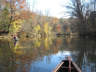
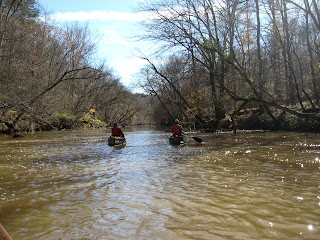
Four inches of rain during the week put the Uwharrie River in near perfect shape for these 3 old guys. I floated with two paddling (floating) buddies from Low Water Bridge at Ophir to Rt 109 bridge.

We were not the only ones out enjoying this day. While stopped at our favorite lunch stop, a beautifully sculpted ridge of blue slate blocking half the river's width, we were joined by 2 other parties in kayaks.

Once beyond this point, the river's declivity increases and the scenery becomes more rugged. The rapids are gentle and forgiving except when one tries to pass over rocks sideways.

I think we pushed a Belted Kingfisher downriver into another's territory. For about a minute or two there ensued a entertaining Kingfisher standoff, with lots of screeching and zipping around. I guess they got things squared away and are back in their respective stake claims now.

What a way to spend a great day.

Sunday, November 8, 2009

Hike up Heartbreak Ridge


Just outside Old Fort, NC, at the edge of the Pisgah National Forest, in the heart of Pisgah Gamelands a trail rises up from the valley to the top of Pinnacle. The climb is steadily up for 6 miles, then rises at a much steeper rate for the final push to the top. Ouch. However, it is hard to beat the view from the top. It is wilderness in every direction. Mt Mitchell and Black Mountain dominate to the west and a sizeable gulf crowds the southwest.

We were not the only ones on the mountain this day. Plenty of bear hunters and their Plott Hounds were out too. I did not see any scat of other bear sign so I don't know how many bears inhabit this area but I suppose there won't be so many bear hunters if there weren't any bears.

I did see an owl silently make its way through a thick spruce forest. Once on top, it was a joy to see the ravens playing in the thermals. I watched one repeatedly drop something red, swoop down and snag it midair.

Thanks to Piedmont Hiking and Outing Club and David Memory for organizing and leading this memorable day in the mountains.

Wednesday, November 4, 2009

Biking Pine Creek Trail


When I first read of this trail, it was described as one of the most scenic in the East. I'd never heard of Pine Creek but soon learned it is also referred to as "the Grand Canyon of Pennsylvania". It follows Pine Creek in a stunning valley from Wellsboro to Jersey Shore just west of Williamsport.

I accessed the trail north of Jersey Shore and rode to Waterville and back, about 25 miles. The trail is the widest rail trail I have ridden. Wonderfully graded and gated and fenced too. For much of my short ride, I followed a somewhat busy road which did detract from the experience. However, the views are stunning. The "creek" is a river by most standards. It looked like a wonderful canoe float too.

When I arrived in Waterville, I noted a lodge and a tavern in addition to a convenience store with a snack bar. This would make a great overnight stop. The trail continues on over 60 miles to Wellsboro which is a quaint tourist stop.

This trail is definitely on my short list of trails to ride. I can't wait to get back on this one.


Biking on the Airline Trail


In 1873 a railroad route between Boston and New York City was constructed. It was the shortest most direct route possible, like a line in the air. There is no other reason such a railroad would link Putnam, Willimantic and East Hampton Connecticut. Most rail trails have a coordinating entity, like a state park or land conservancy, this one does it. It appears to be built and maintained by the towns it travels through. Hence, there is always someone in the middle who doesn't follow along. I found this out after biking 23 miles from East Hampton to the Willimantic River where there was no passable bridge. So I turned around and rode back. Original plans were to continue on to Thompson and spend the night. As a result, I didn't travel beyond the Willimantic River and no idea what that portion of the trail is like.

It was a colorful ride. Foliage was a bit past prime but still very nice. The trail had some unique infrastructure. The two original 1000+ foot trestles were replaced long ago by filling them in with stone and dirt. They are called viaducts but resemble earthen dams (without a lake).

Not many folks were out in the rain so I had the trail to myself most of the time. I sure was hungry by mid-afternoon. I had planned to eat in Willimantic but never got there and there were no other services along the trail.

Someday I'll finish riding this trail and perhaps the spur to Colchester as well.

More Photos of this ride

Monday, October 12, 2009

A walk to Springer Point


Everyone associates Ocracoke Island and Blackbeard the pirate. Well, this is the place he hung out, just off Springer Point. Ocracoke Inlet between Ocracoke Island and Portsmouth Island was the best route from the Atlantic into Pamlico Sound and the many colonial era towns on the mainland. Just outside the inlet was a perfect hiding spot for pirates. It was hidden from view from ships entering and leaving the inlet. Ocracoke Island rises up to its highest point near here and there is a little cove, referred to as "Teach's Hole".

Today Springer Point and the nearby forest is protected by the North Carolina Coastal Land Trust. They allow access along a footpath. Live oaks and coastal red cedars dominate the tangled forest. There is no parking at the only trailhead so it is often a private place. Take a walk through with me.

Nov 19 Quechee Gorge

  At 165 feet deep, Quechee Gorge is the deepest gorge in Vermont. The Ottauquechee River flows through it. The name is derived from a Natic...