Today's hike on Boone Fork Trail was to get a better look at a hike I'd like to lead for Piedmont Hiking and Outing Club later this summer. Never having walked this trail before I carried my autographed copy of Randy Johnson's hiking guide, my Garmin GPS and was accompanied by two seasoned PHOC hiking companions.
The trail is a 4.9 mile loop. Mileage is measured and signed beginning at the Price Park Picnic Area on the Blue Ridge Parkway. Rather than start our hike there, we chose to continue along the BRP a short distance and access the Tanawha Trail on Holloway Mountain Road. That decision led to a couple encounters with a road grader on a narrow winding gravel roadway. Eventually, the trail head was located at a wide spot in the road and we embarked on the Tanawha Trail. In the Cherokee language, Tanawha is a "fabulous hawk or eagle". Hence the trail is signed with a white feather.
We followed the Tanawha Trail for less than a mile awed by the brilliant flame azalea displays. At this point the Tanawha "t's" into the Boone Fork Trail. We have the option of going in either direction and opt to go left following the MST as well. There are some mucky areas and a couple of stream crossings that require steady nerves. The trail and Bee Tree Creek morph into one another at a couple points assuring wet boots.
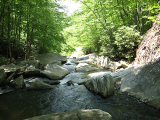
Bee Tree falls into the larger Boone Fork and the trail hugs the steep banks of Boone Fork for a couple miles leading to the picnic area. There are water falls, cascades, magnificent rocks and rugged terrain. One short ladder needs to be negotiated. Be sure to check out the cave at the top of the ladder. As we approach the picnic area, many more people are encountered. This appears to be a big weekend draw as there are many side spurs leading down to the river.
The picnic area is a series of open fields with a narrow strip of trees protecting a small creek. Although the trail officially starts and ends here, we continue on, passing through the campground and beside another bathroom before heading back into the wood. From this point it is a short stroll back to the Tanawha Trail and our vehicle parked on a newly graded gravel road.
The total mileage is between 6 and 7 miles and the elevation gain is mere 900 feet. So for PHOC rating purposes this is a a pretty easy hike. Due to the creek crossing and rocky terrain I will rate this a R-21. Still an easy hike.


No comments:
Post a Comment