Late in the afternoon, Nov 23, a fire was started along the Chimney Tops trail in the general vicinity where another fire was started a week earlier. The first fire was extinguished. The second, now known as Chimney Tops 2, was contained to a same area for 4 days. National Park firefighters did not actively try to contain the fire during this period, relying on national boundaries which, in normal conditions, would contain the fire.
On Nov 27, water was dropped on the fire via 3 helicopters, loading up with water from Fontana Lake, 8 miles away. This helped to suppress the fire but not extinguish it. The fire had grown to about a 35 acre area by evening. Drastic weather changes were to come that night. Very low humidity, less than 20% and winds, began to spread the fire.
November 28 did not go well. Wind picked up during the day, expanding the fire and causing it to jump Newfound Gap Rd (Rt 441) and other natural boundaries. Cove Mountain weather station reported a wind gust at 87 mph just before it lost power. A voluntary and then mandatory evacuation of Gatlinburg was ordered. High winds carrying huge embers, spread the fire miles in a very short period. By evening, the fire roared through Gatlinburg in about 30 minutes. A separate fire started at nearby Cobbly Knob caused by a downed power line. Several spots near Pigeon Forge and along Middle Creek burned as well as spots to the west near Wears Valley.
When rain finally dampened the spread of the fire, damage assessments were made:
14 dead
2460 buildings damaged or destroyed including 2000 homes
$500,000,000 damage
1794 acres
Cost to fight, about $9m
Amount raised by Dolly Parton to help those who lost homes - $9+ million
I knew the Baskins Creek area of Gatlinburg had been hit very hard. The only hike I wanted to do today was to Baskins Creek Falls. I had spread my fathers ashes here several years ago and was interested to see what it looked like now. Beginning in downtown Gatlinburg, I walked up Baskins Creek Road. About 1/4 mile from the main street, I began to see fire damage, leveled building and burnt out vehicles
On Dec 7, residents were allowed back in the area to search through their homes. Several of the homes I saw, had trinkets displayed, obviously fished from the ashes. A few places had them lined up on a mantle or rock wall which had survived. One collection of items included the ceramic houses that folks dress up in a holiday village during Christmastime. They had all turned white but did not melt. Some of things I did see melted were piles of aluminum and vinyl siding still clinging to home which remained standing. A few places, which were now leveled, had completely intact structures just feet from the rubble. I saw a wood swing still standing and a number of garden or lawn items still standing.
Demolition of what was left was ongoing this morning. Rubble was being separated into piles of metal and piles of stone. Then those piles were being loaded into containers or on trailers and hauled off.
The waterfall and immediate surrounding area was not burned, but almost everything else here did.
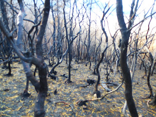
Most areas I walked through, were burned only at ground level. Fire scars on trees rarely were higher 6 feet. Laurel and Rhododendron burned up but in many cases the leaves just turned yellow and lay on the burnt ground. Leaf litter was quite thick in spots, maybe as much as a foot thick of, now, burnt leaf litter.
There is a small cemetery near the waterfall. I visited it and continued walking up toward Cherokee Orchard Road. Here, the fire produced some eerie sights.After leaving the trail, I walked 4 miles on the roadway back to Gatlinburg. Most of this area burned, exposing bottles and cans which had been thrown from car windows for years.
At the outskirts of town, I saw another 4 houses gone. Many folks were out in the yard tidying up, spreading mulch and trying to make home a home again.


No comments:
Post a Comment