I'm channeling Joe Moffitt today. His book An Afternoon Hike into the Past is my guide.
We call it Plantation Road but Joe says it was known as the Byway or more formally the Salisbury-Fayetteville trail. It would have gone through Strieby along the way and right past the home of Christopher "Kit" Bingham on what was then called Grassy Ridge. Joe placed an aluminum sign at the site of the house. There are 2 piles of rocks there which were, likely, the two chimneys. The family cemetery with 35-40 graves lies about 200 yards from the site. Kit is buried there (date of death 1869 at age 103 or 104) as is his wife Dolly and grandson Rudsell Bingham.
Island in the river looks to be manmade
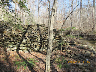
After checking around the homesite, I walked along the old road until it crosses Hannah's Creek where Kit had a corn and grain mill according to Joe. This puzzles me since this dam appears to be a detention dam not a regular dam which would have impounded water for a pond. Perhaps the dam's center had been washed away. That would have been a powerful event to cause stone to wash away.
It is a sizeable structure. Both the photo above and photo below are both sides of the dam. From the upriver side, you barely can tell there is a dam.
On this trip, I did not cross the creek here but did see a large flat area on the other side which may hold some more clues as to what went on here long ago.
Just upriver from the dam, the river divides and creates an island. This appears manmade to me and if it is, why would someone create a second river channel if there is a dam impounding water here?
To add more intrigue, on the nearby hillside are a number of small rectangular stones on the ground. it reminds me of a graveyard. I am not prepared to call it such as it is not level and periwinkle is missing but caught my eye.


No comments:
Post a Comment