Thursday, March 5, 2020

Feb 10 Birkhead Clean-up


It was a great day to be out enjoying the forest. My route was to hike the Camp 3 Trail with my handsaw, just in case. I did remove it once from its sheath. Camp 3 Trail has lots of blowdowns too big for a handsaw to remove. So, the best I can do, is create a nice walk around trail.

Then I came upon this collapsed tent and accompanying mess. We had a 4" rainfall on Friday. Surely, someone would not try to camp out in that. However, it does appear that is the case here. Outside the tent was a feeble attempt to start a wood fire. Inside the tent were the remains of another wood fire. Yes, inside. I could see where that fire had started melting the tent. Perhaps that was the moment to vacate. 


Fires inside tents are poor decisions


Next day, six Uwharrie Trailblazers hike in with oversized garbage bags to clean the mess. The brand new $39.99 tent (yes, price tag was there) and assorted "Ozark Trail" camping equipment, also brand new but now useless, were bagged up for the hike out. We squeezed as much water as we could out of the 4 blankets before carrying them out too. 


Thanks for the help keeping the forest clean


Friday, February 7, 2020

Feb 2 Rocky Knob and Mt Graybeard


Today's hike will traverse trails I had hiked yesterday on the way to Walkers Knob. It would be a bit more adventurous since the plan was to hike trails to the vicinity of Rocky Knob, then scramble in the snow to the top of Rocky Knob and then offtrail to Graybeard and back to Montreat.


We started again at the Graybeard Trail parking area, up the Graybeard Trail, but after the 3rd rock hop, we crossed the creek a 4th time and continued to the Old Mitchell Toll Road. The road is passable with high clearance 4WD and is open one day during the year to vehicles. We walked the easy grade, stopping at a few overlooks. We also passed the former McPeterson home. Mr McPeterson had spent 40 years living here and passed away several years ago. His ramshackle place is an oddity in this wilderness. There is a nearby spring with a holding tank. It would have provided a good source of water for all those years on the mountain. 


With Pinnacle Mountain overlooking us, we stopped in a sunny spot out of the wind to eat lunch. Although, out of the wind, we could hear its roar nearby. 

After our break, we found the manway leading to Rocky Knob. The path was covered in snow and presented a challenging scramble. At the top, we had a small area to access the views. The wind kept our stay short. We were soon retracing our steps back through the snow.


About halfway back to the Toll Road, there was a a faint path marked intermittently with orange flagging. Our group tromped through here, trying not to slip in the snow. I had seen the route we might take from the top of Rocky Knob. It looked like a long climb up Graybeard. 


With only minor difficulty, we ascended the thick forest, sheltered from the wind, on a faint pathway, still marked with orange flagging. When we popped out at the top of Graybeard, the most ferocious wind of the day greeted us. After a short break, we vacated the summit and headed down on a real trail. As I began to leave, a gust of wind blew my hat off. I thought I might never see it again. About 50 feet down the trail, there it was, snagged in some Rhododendron. 


Quick stop atop Graybeard

On the route down, we stopped for another break at Walkers Knob. The view which was so fleeting the day before, was clear as could be today.

After another combination of trails, we ended up taking the Sanctuary and Harry Bryan Trails as we approached the developed area of Montreat. It was a tough 10 miles day but my rib managed fine.


Feb 1 Walkers Knob Hike


Above, the metal rungs of an old wooden water pipe lie beside the trail. I'm told this pipe transported water for a small hydro-electric plant in Montreat.


From the Graybread Trail parking area, we started up the Graybeard Trail through a very rocky area, steadily climbing alongside Flat Creek. After 3 rock hop crossings, we walked the gentle ascent on the old trestle. The switchbacks are quite long and add substantially to the length of the trail.  


Graybeard Falls adds a nice touch to our hike. Snow had accumulated from yesterday. As we hiked higher, it was a couple inches deep. However, with so many people hiking the trails, it made for a slippery mess, especially descending.


Just before reaching Walkers Knob, a red shelter appears. It is the only place in the Montreat Wilderness, camping is permitted. We had met three backpackers earlier on the hike. They had spent the night here. The two in hammocks said it was really cold. 


The walk out to Walkers Knob was short. We got a glimpse of the view below before low clouds blew through and obscured the landscape.


Our return rote was via a shortcut trail, eliminating the long switchbacks of the trestle. 
The retaining wall above, may have been a water stop for the train. It is located right next to a creek which could easily have provided gravity fed water. We also saw coal ash or cinders. Possibly, while trains were stopped, taking on water, coal ash could have been dumped here. 


The snow and ice made my descent slow and deliberate. My rib has been healing but a fall here would have been painful. 


Sunday, January 26, 2020

Jan 23 Winter Hike Week - Courthouse Rock


Heading up Rt 441 (Newfound Gap Road), I was searching for the two car pulloff near the start of this offtrail adventure. Suddenly, we spotted a large group of colorful hikers working their way up a drainage. Eventually, I settled on a nearby pulloff and we began our hike. There is no trailhead and no official trail. I knew to look for an old section of road which got bypassed when the park improved Rt 441. Once on the old road, there is a faint and unmaintained trail. The trail heads up the drainage created by Road Turn Branch. It is here we ran into Bill Little, a senior hiker who decided the creek crossing was too precarious for him. He didn't seem the least bit concerned to have been left behind by his group.

Once we made the creek crossing, we came upon the cave pictured above. It is more substantial that it looks. The rock wall in front may have been larger at one time. This cave is called "Moonshine Cave". It sounded like there was running water within it but it may have been an echo from a nearby creek.  


The November 2016 Chimney Tops 2 fire impacted the area nearby. We saw some fire damage in our vicinity but nothing like the nearby mountains. Chimney Tops (not pictured here) was visible and quite noticeably barren. 


I assume Courthouse Rock gets its name because it is as large as a courthouse. It does appear to be quite large as you approach it. I'm told it is the largest free standing rock in the park. However, it is quite skinny as you can see in the photo second below. 

We finally caught up with the group we spotted climbing the drainage. The same group that left Bill Little behind. After a short conversation, I learn they are the Thursday Hikers from Knoxville. I ask if Gary Anderson is among them. And yes, he is standing just a few feet away. I first met Gary while hiking off trail in White Oak Sinks in the rain. We both were carrying umbrellas during this chance encounter. I learned he was from my hometown and now lived in Knoxville. We corresponded for years but lost touch until today. While getting reacquainted, one of their group came by and offered some candy from a small duffel bag. He introduced himself and let us know he was 90 years old.  

GA BARBER 1827

Its really is this skinny


Next stop is Road Turn Falls. Along the way, we ran into Bob and Tom, a couple former telephone guys. I had seen them getting out of their truck back when we started our hike. 


After we had our fill of the waterfall and the frozen icicles nearby, we retraced our steps back to our vehicle. On the way, we ran into Bill Little again. He was back at the creek crossing and suggested we look for his truck back on Rt 441. There were drinks and treats there and we should help ourselves. 

As we made our final turn to move away from the creek, I realized the old road made a very pronounced horseshoe turn with the creek bisecting the horseshoe. It dawned on me that this is how Road Turn Branch acquired its name. 

Jan 22 Winter Hike Week - Sugarlands Rockhouse


Another cold day at WHW. Our group of 12 began hiking on the Old Sugarlands Trail. The roar of the creek accompanied us. I don't know if it is called the Little Pigeon River here but that is what it becomes outside the park. 

About a mile in, we arrive at the former CCC camp 1458 and 1459. The structure above is what remains of the clock tower at the camp. Below there is a circular structure which may have been a fountain.


A little exploration of the surrounding area reveals one of the main camp structures. All that remains are the two massive chimneys and camp relics. We also located what appeared to be the camp dump. The dishes used were thick white china from West Virginia. Quite a few pieces were laying nearby.


We then continued on to the Burton-Ogle Cemetery where we stopped for a look around.


From the cemetery, we followed an old road and then an overgrown path through a forest of white oak and black locust. The bugaboo between us and the rockhouse is a creek - Big Branch. Sometimes you can rock hop and sometimes it is a bit too intimidating. Today its intimidating but there is a very strategically fallen tree allowing us to navigate the creek crossing without mishap. 


There has been some damage to the structure since the last time I was here. A tree has fallen and knocked over one side. 


This corner looks like it might not be here next time I visit.


The rockhouse does not appear on any early USGS topographical maps, including the 1931 map which I was using. However, it does show up on the 1942 USGS map, sparking speculation that the rockhouse was constructed by the CCC, surreptitiously in the park. It contains a number of metal bed frames. There were numerous quart conetop beer cans found nearby. This leads one to think it might have been a party spot, possibly for CCC officers.  

Crossing Big Branch


Jan 21 Winter Hike Week - House of the Fairies


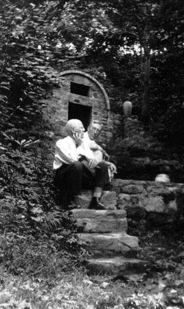
One of the fanciest springhouses ever built now masquerades as the "House of the Fairies". The structure was built as part of the Louis Voorheis estate built around 1930. Voorheis incorporated waterworks on his 30 acres. With the twin creeks - Scratch Britches and LeConte, he had ample water and declivity to install fountains and small impoundments. His estate was deeded to the park in the late 1930s. Many of his original building still exist and are part of the GSMNP Twin Creeks Science and Resource Center. 

A man sits on a set of stone stairs, hand on his chin and facing away from the camera into trees
Louis Voorheis at the Springhouse
Photo from NPS


View from the top


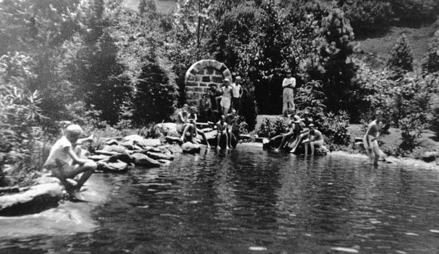
Voorheis swimming pool is nearby as we made our way to the Fairy House

Photo below from NPS
Bathers gather at the edge of a pool of water, near a brick structure marking a spring

Jan 20 Winter hike Week Laurel Falls


Warning
Do not sign up for hikes led by Jim Plant


He has a broken rib and will be hiking at “broken rib” pace.
He is known to pick hikes that have unbridged creek
crossings, is prone to stop mid-hike to talk about
a dang fungus or fern.  All his hikes will be off trail.
Avoid at all costs. Hike with George, Rick or even Darcy,
before you sign up for one of Jim’s hikes


This is my WHW pre-hike. Laurel Falls is a 1.7 mile paved trail to a quite attractive waterfall. It is one of the most popular trails in the park. My most memorable hike here was in January 2013 when Wilderness Wildlife Week shut down for the day due to heavy rains. It was the same day a landslide covered up a portion of Newfound Gap Road and closed it for several months. Click this link to see it.

The hike and falls were much tamer on this trip. My rib appreciated the light hike.


Nov 8 Petrified Forest

  Just outside Escalante is the Petrified Forest State Park. We hiked a several mile route to view many specimens of petrified wood. These s...