Another cold day at WHW. Our group of 12 began hiking on the Old Sugarlands Trail. The roar of the creek accompanied us. I don't know if it is called the Little Pigeon River here but that is what it becomes outside the park.
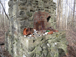
About a mile in, we arrive at the former CCC camp 1458 and 1459. The structure above is what remains of the clock tower at the camp. Below there is a circular structure which may have been a fountain.
A little exploration of the surrounding area reveals one of the main camp structures. All that remains are the two massive chimneys and camp relics. We also located what appeared to be the camp dump. The dishes used were thick white china from West Virginia. Quite a few pieces were laying nearby.
We then continued on to the Burton-Ogle Cemetery where we stopped for a look around.
From the cemetery, we followed an old road and then an overgrown path through a forest of white oak and black locust. The bugaboo between us and the rockhouse is a creek - Big Branch. Sometimes you can rock hop and sometimes it is a bit too intimidating. Today its intimidating but there is a very strategically fallen tree allowing us to navigate the creek crossing without mishap.
There has been some damage to the structure since the last time I was here. A tree has fallen and knocked over one side.
This corner looks like it might not be here next time I visit.
The rockhouse does not appear on any early USGS topographical maps, including the 1931 map which I was using. However, it does show up on the 1942 USGS map, sparking speculation that the rockhouse was constructed by the CCC, surreptitiously in the park. It contains a number of metal bed frames. There were numerous quart conetop beer cans found nearby. This leads one to think it might have been a party spot, possibly for CCC officers.
Crossing Big Branch


No comments:
Post a Comment