My first visit to this state park! We are quite fortunate to have this state park. It could have turned out much differently.
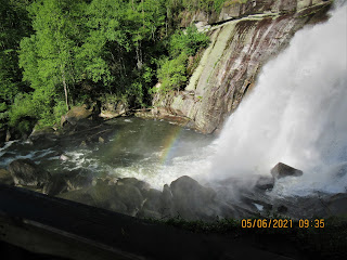
Rainbow Falls. Yes, there is a rainbow here.
The mist from the waterfall rises up over the nearby hillside. This constant mist supports many rare and unusual species. Some, are tropical and not found elsewhere for hundreds or thousands of miles. Ferns, mosses and liverworts can thrive in this environment. Due to the tectonic activity which created the Blue Ridge, this area rises up a couple thousands feet. Moisture from the Gulf of Mexico stalls at that wall and provides significant rainfall. The average is 91 inches per year. By comparison, Asheboro, NC gets an average of 44 inches. All this water and topography have created the Jocassee Gorges. Initially, it attracted vacation developers and later hydroelectric power companies.
Two rivers flow through the park. Rainbow Falls is on the Horsepasture River and the Toxaway River supports Bearwallow Falls. Those two rivers flow into SC and form Lake Jocassee. There are a series of other lakes as well. They end up forming the Savannah River.
The early recreational and vacation infrastructure began in the late 1800s. In 1903, Lake Toxaway was created by the largest privately held dam in NC. Development of that area was shattered in the summer of 1916 when tropical storms and run off from timber operation, burst the dam, releasing 5 billion gallons of water down the Toxaway River. The resulting flood scoured the gorges and left debris piles 20 feet high. Some of that debris can still be seen over a hundred years later. As a result, development ceased and many locals sold their land to Singer Sewing Machine Company. Singer cut timber and by the 1940s and 1950s sold the land to Duke Power. Duke envisioned a huge hydroelectric operation, with dams and piping water out of riverbeds.
In 1984 another power company, Carrasan placed a tiny public announcement in a local newspaper advising that they would be damming the Horsepasture River for a hydroelectric power station. A local Dupont employee who loved hiking and wildlife, became alarmed that his favorite hiking area was going to be a lake. Bill Thomas and his wife became the voice of the opposition. They formed an organization - Friends of the Horsepasture River (FROTH). Never having done this type of thing before, he surprisingly, got much accomplished in a short period of time. The Horsepasture River was declared a National Wild and Scenic River in 1986. This thrust Bill Thomas into a new career with the Sierra Club. Initially, the effort centered on acquiring Carrasan's land. When Duke Power saw how the local opposition to power development went for Carrasan, they decided they would not be able to pursue their plans. Duke sold most of their lands as well. All this created a 100,000 acre conserved area along the NC/SC border. It included the 7700 acre Gorges State Park.


No comments:
Post a Comment