I was not aware of a trail leading up Sauratown Mountain until Will mentioned one. The plan was rather open-ended. We would meet at Camp Hanes, look for a trailhead and see what was there. He had a vague idea that we could reach the top by heading up and going right along the base of the cliff.
The trail was in great shape. There were lots and lots of rocks but the trail had been professionally done and was easy walking albeit uphill.
As we reached the midway point and crossed a small creek, we saw a sign but it was not facing us. We felt it must have been part of an earlier trail.
When we reached the base of the cliff, we could see that it was a vertical wall both to the right and left. We wandered around for a bit and determined that we might be able to head up through a gap in the wall. It looked doable but once I had gotten partway up, I could see that we had a very long way to go and it was not going to be safe. After turning back, we ran into some climbers and chatted with them for a few minutes. They didn't know if a trail went to the top or not. They did point to a rope embedded in the wall and said we could swing over this abyss and the trail continued. Maybe 20 years ago, we would have taken this route but we suffer from age now.
Back tracking a bit we found a well worn path which headed along the cliff base going left or west. We followed this and ran into several groups of climbers. Everyone told us, the trail got rough but none of them knew if it went to the top.
We pushed on through trail which had been recently cleared but still a scramble in many spots. There was one place in particular, we slid down one at a time in case rocks were dislodged. I didn't think we'd be able to go back up that spot, so we'd have to find another way back.
It seemed a long time scrambling along the base. Then we made an abrupt turn and saw a sign with "11" on it. No clue what that was about. Now the path was more obscure and choked with greenbrier. Devil's Walking Stick was strategically placed here too. Suddenly, we had a nice view and could see one of the communication towers right above us. It looks like a short scramble through more greenbrier. We popped out on top between two towers and near the end of the gravel road on top. Clearly, this was a gated road as we saw no traffic on it for the 30 minutes or so we were on top.
It's gnarly in spots
Almost on top
That's Pilot Mountain out there
We ate lunch with a grand view. We could pick out the cities to the south and some of the Uwharrie peaks. To the west, we could see a few peaks but probably not as far as the Brushies. To the north, the Blue Ridge was in view with easy to identify Bull Mountain.
This building has a chain-link fence around it. There was also a stone wall just outside the fence which we were able to walk on to get past the building and drop down to the final tower on the mountain.
Covington Mtn Fire Tower
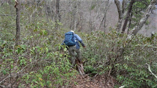
We had picked out our route while sitting for lunch. It looked much easier than it turned out. We entered a rhododendron hell which had greenbrier to boot. As we thrashed through the thickness, Will said "it is kind of a sickness, but I like this stuff".
A Rhodo hell
We crashed our way down to open forest and eventually found ourselves on an unmaintained trail which had recently had some minor clipping done. This led us to an old stone foundation and eventually to the maintained trail. From there is was a simple walk back out to Camp Hanes.
Old foundation
Nice rock work for hiking


No comments:
Post a Comment