It is a stunningly beautiful day and we are headed to Forty Acre Rock near Kershaw SC. Will and I have made two previous trip and are bringing good friend Rick along for this tour. Rick is showing off his camera above. I have used a number of his photos in this post. You should be able to see the difference.
We began hiking from the lower parking area, heading for Naked Falls first. The area around the waterfall was sporting a carpet of Trout Lilies. Will said his SEEK app identified them as Fern Lilies. We climbed the trail next to waterfall. Rick is taking a photo from the waterfall top. The water just glides over the smooth rock here.
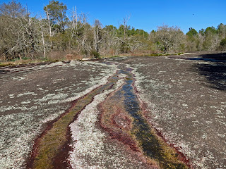
We are on the main rock. It is evident the pandemic year of 2020 has left a fresh compliment of graffiti. We spend some time walking around the rock, looking for other trails and inspecting all the pools. There are a few other folks roaming around too.
After a grand tour of the main rock, we slip down a slight drainage to get onto the other rock areas. Before touring them, we drop down to see another waterfall and the cave beside it. The cave has been painted so many times during the past year, I'm calling it the Covid Cave.
Elf Orpine
We explore the smaller rock areas and sit for lunch at a very nice spot. Water trickles along these rocks more than the main rock. The waterways and pools fill with Elf Orpine and other succulents. Mosses and Reindeer lichen enhance the rock gardens.
On google earth, I spotted a rock we had not visited before. We had to go through a wooded area using a privately owned field as a guide to lead the way. And there it was. Each rock seems to have a different dynamic going on. This one was a bit drier but a beauty, just like the others. Other hikers have been here before but this is undoubtedly the most remote and least visited.
Slipping down into a gulley, we try to stay in the woods, making our way to the next area of exploration. When we get to a powerline, we decide to head out to the road and walk along it. Our target is a creek on the other side of Nature Preserve Road. The spot to turn into the woods is a flat area of road with a one car pull in spot. Here we head into the woods, passing an old farm or timbering dump. The old road leads to a small waterfall and creek.
It is a small waterfall but quite scenic. Just downstream from here, the creek disappears under a rock jumble. You can get inside the jumble and climb around, listening to the creek crashing down rocks below you but out of sight.
Rock jumble with underground creek
Will's plan all along, has been to walk up a side drainage here. We do that and see large rock outcropping and erratically placed boulders. As we walk around here, we keep seeing interesting boulders and keep walking.
We are amazed to see so many and that they are solitary and so oddly placed. This goes on for a good 1/4 mile. We are roughly walking downstream but just out of sight and sound of the creek.
We are not able to cross the creek, so we walk alongside it until we reach old 601. The road is overgrown but there is a bridge over the creek and we make our way back toward the parking area. But wait. there is one more stop. I had seen on GIS a cemetery across Rt 601. We walk over to it. It is on a gated road a couple hundred yards back in the woods.


No comments:
Post a Comment