Wednesday, February 17, 2021

Jan 12 Caw Caw


Caw Caw Interpretive Center is a Charleston County Park encompassing land which made up parts of several rice plantations. We walked over the entire park mainly bird watching. Just before leaving we came to the site of the Locust Hill Plantation manor house. There was nothing remaining. When reading about the plantation later, I learned that many of the slaves from Locust Hill joined the Stono Rebellion or the Slave Rebellion of 1739. The store where the slaves armed themselves was very near the plantation. After arming themselves, a number of Locust Hill slaves joined the group.


Here is the story copied from PBS.org:

What exactly triggered the Stono Rebellion is not clear. Many slaves knew that small groups of runaways had made their way from South Carolina to Florida, where they had been given freedom and land. Looking to cause unrest within the English colonies, the Spanish had issued a proclamation stating that any slave who deserted to St Augustine would be given the same treatment. Certainly this influenced the potential rebels and made them willing to accept their situation. A fall epidemic had disrupted the colonial government in nearby Charlestown (Charleston), and word had just arrived that England and Spain were at war, raising hopes that the Spanish in St. Augustine would give a positive reception to slaves escaping from Carolina plantations. But what may have actually triggered the rebellion on September 9th was the soon-to-be-enacted Security Act.

In mid-August, a Charlestown newspaper announced the Security Act. A response to the white's fears of insurrection, the act required that all white men carry firearms to church on Sundays, a time when whites usually didn't carry weapons and slaves were allowed to work for themselves. Anyone who didn't comply with the new law by September 29 would be subjected to a fine.

Whatever triggered the Rebellion, early on the morning of the 9th, a Sunday, about twenty slaves gathered near the Stono River in St. Paul's Parish, less than twenty miles from Charlestown. The slaves went to a shop that sold firearms and ammunition, armed themselves, then killed the two shopkeepers who were manning the shop. From there the band walked to the house of a Mr. Godfrey, where they burned the house and killed Godfrey and his son and daughter. They headed south. It was not yet dawn when they reached Wallace's Tavern. Because the innkeeper at the tavern was kind to his slaves, his life was spared. The white inhabitants of the next six or so houses they reach were not so lucky -- all were killed. The slaves belonging to Thomas Rose successfully hid their master, but they were forced to join the rebellion. (They would later be rewarded. See Report re. Stono Rebellion Slave-Catchers.) Other slaves willingly joined the rebellion. By eleven in the morning, the group was about 50 strong. The few whites whom they now encountered were chased and killed, though one individual, Lieutenant Governor Bull, eluded the rebels and rode to spread the alarm.

The slaves stopped in a large field late that afternoon, just before reaching the Edisto River. They had marched over ten miles and killed between twenty and twenty-five whites.

Around four in the afternoon, somewhere between twenty and 100 whites had set out in armed pursuit. When they approached the rebels, the slaves fired two shots. The whites returned fire, bringing down fourteen of the slaves. By dusk, about thirty slaves were dead and at least thirty had escaped. Most were captured over the next month, then executed; the rest were captured over the following six months -- all except one who remained a fugitive for three years.

Uncomfortable with the increasing numbers of blacks for some time, the white colonists had been working on a Negro Act that would limit the privileges of slaves. This act was quickly finalized and approved after the Stono Rebellion. No longer would slaves be allowed to grow their own food, assemble in groups, earn their own money, or learn to read. Some of these restrictions had been in effect before the Negro Act, but had not been strictly enforced.


Monday, January 11, 2021

Jan 11 Dungannon Plantation and Heritage Preserve


An Honest Man is the Work of God

Another former plantation, now a wildlife preserve. This one had a maze of roads and hard to follow trails. However, we managed to make it out to the Wood Stork lake. As soon as we arrived, one Wood Stork took off and a Great Blue Heron squawked and squawked at us. It must have been announcing our presence to its friends. We didn't see another for our 30 minute visit. We did spot a Belter Kingfisher, Flicker, Phoebe, a couple Cardinals, then a Sharp Shinned Hawk landed on a branch just above us. A Downy was spotted too. 

The preserve is the 3rd largest nesting site in SC for federally endangered Wood Storks.


Most of what I have found out about the former plantation is from the writings and memoir of Rosalie Roos, a Swedish activist. She served as a governess for the 2 Peronneau girls for 4 years. Although, she opposed slavery and never abandoned her opposition, she wrote the 60 slaves at the plantation were not mistreated and appeared content. 

A book published in 2002 entitled Slavery and Emancipation describes the letters and diaries of Rosalie Roos as “one of the most interesting and least-known documents” on antebellum Southern society, but includes only a brief excerpt from her writings concerning courtship customs.


There were only songbirds around this water. I assume the larger birds can't see the fish, so they hang out in non-algae waters. 


Another rice plantation? Maybe.

Jan 10 Botany Bay


Ice house 

Botany Bay Heritage Preserve is a former rice plantation near Edisto Beach. The main house is long gone. It was named  the "Bleak House". The Charles Dickens satirical novel was the inspiration. An odd choice in my mind but I don't know the back story. The ice house remains. Ice was shipped from New England during the winter and stored beneath the floorboards, insulated with sawdust. 


What have we here? Out in the woods behind the plantation site is the east end of Bache's baseline. I guess we are 7 miles, give or take a couple inches, from where we were earlier at the west end.


If a place is going to have a cool name like Botany Bay, it better be a cool place. This qualifies.


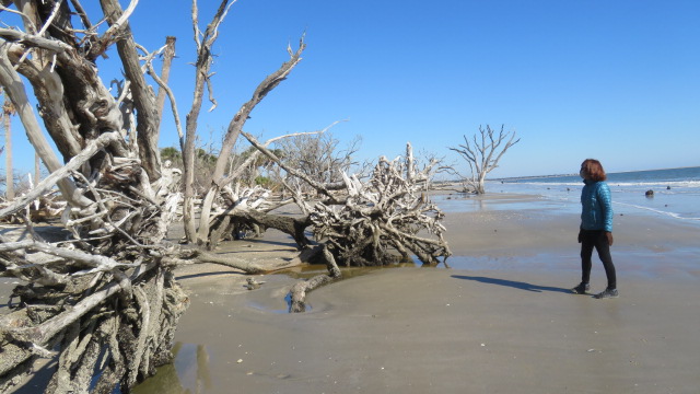
When I first learned of Botany Bay, I assumed the trees were deposited here by currents. That is not the case. The ocean is eroding the shore and has reached into what was once a forest with massive trees. Some are still rooted and upright and others have toppled. It is one of the coolest places I have ever seen.


Since 2010, it is prohibited to collect any shells or wood from the beach. It is a bit of a walk from the parking area. No dogs are allowed either. 


Jan 10 Edisto Beach State Park


Oysters

Our visit to Edisto Beach State Park is a first time visit. There is a beach. It is adjacent to the town of Edisto Beach. There are lots of beaches around here. That was not our focus. I wanted to see the 4000 year old oyster shell midden. We had to walk 7 miles to do that but also learned about Alexander Bache and coastal survey as a bonus.

Grape vine


I have never heard of this guy before. Alexander Dallas Bache was a brilliant guy. Being the great grandson of Benjamin Franklin may have had something to do with that. After graduating from West Point and serving in the army, he went on to head the US Coastal Survey. His invention, the Bar of Invariable Length was used  to make surveying more accurate. In 1849 surveying was a tedious job. Mapping the US coast was needed for military and shipping concerns. Bache headed up this effort. On Edisto Island he contracted with a local planation to cut a "straight as an arrow", road, 7 miles long. This is known as establishing the baseline of a survey triangle. Surveying then and today is all about trigonometry and triangulation. Bache's "bar" was made of two rods of different metals. Since metals shrink and expand with temperature changes, Bache chose two metals that cancelled each other out. Thus he now had a long rod or bar of invariable length that could be used to survey that 7 mile long road. Using tripods, the long bar was leapfrogged from one end to the other. Stone monuments marked either end. Under the monument was a brass bolt that marked the exact point. In the 1990s a gps survey was conducted to test the accuracy of Bache's measurement. He was off by less than 2 1/2 inches.

A couple points of trivia here. Bache was the the first president of the US National Academy of Science. He was the first person to hire a woman for a scientific position. And he roomed with a president at West Point, Jefferson Davis. 


Bache monument west end of baseline


Along one of the creeks in the state park, is this Native American midden. It dates back 4000 years. Although, mostly oyster shells, it also has fish, bird and animal bones and broken pottery. The midden is only a small fraction of its original side. The creek has been eroding the mound. 


Saturday, January 9, 2021

Jan 9 Walker Creek Trailhead


In a Covid world, ribbon cuttings are weird.  That is Terry Savery with the US Forest Service out front. Behind her are members of the Uwharrie Trailblazers including Dave Gardener and Merritt Maness - tireless trail volunteers, Joey Moffitt whose father is the father of the Uwharrie Trail, lawrence Bachman, Eric Kalin, David Craft - the guy who makes things happen, Mary Joan Pugh who initiated the purchase of the property and Crystal Cockman who has spent her career protecting the Uwharries. I believe they are all smiling.


It was years in the making and many people had a hand in making it possible. Now everyone can enjoy it. The Uwharrie National Forest has officially opened the Walker Creek Trailhead to the public. Two and a half miles of new trail have been added to the Uwharrie National Recreation Trail, now 26.2 miles, a marathon. 

Note the weathered sign and kiosk in the background. The QR code is part of a audio tour of the Uwharries. 


The parking area, fencing, kiosk and trail and road signs were all paid using private funds. The trail was built by and is maintained by volunteers. The land the trailhead sits on, was sold to the Forest Service at a bargain price by a non profit organization. Dedicated and civic minded people made this happen.


The address is 6871 High Pine Church Road, Asheboro NC. The trailhead now appears on google maps. There is a short but steep drive to the parking area. Plenty of overflow parking too.


The property was once a home and a few of the buildings still exist.


If you stroll up the gravel drive beyond the gate, there is a nice north facing view of the Uwharrie River valley.

Lets Hike


Starting at the parking area, the trail enters a mixed hardwood forest along an old road.

At 0.1 mile there is a side trail signed "Slate Pile", leading to - you guessed it, a slate pile. And a rather small one at that.

In and out of new forest and old forest, the trail winds its way until you are on a well defined old road. pay attention here to the trail blazes (or "reassurance markers" in Forestservicespeak). 

At 0.7 mile there is an abrupt left turn into mature forest.


At 0.9 mile you walk through a spot where several very large Red Oaks uprooted. The Uwharrie Trailblazers Saw Crew spend an entire workday sawing through this mess last year.


At 1.0 mile you'll see this rusted piece of equipment. If this were found in New England, it most likely would have been used to boil Sugar Maple sap into syrup. Here is was probably used to boil sorghum sap into sugar, one of the main ingredients for moonshine. Sorghum would have been harvested and squeezed by a horse operated cane mill to extract a gooey green liquid. The liquid would be boiled to sugar on this type of kiln. 


At 1.3 miles the trail crosses Walker Creek. Just downstream from here is a lovely lunch spot among a number of boulders in the creek. These boulders are referred to often as "Biscuit Rocks". 

A bit further at 1.7 miles is an upland pool on the right. Upland pools are important breeding spots for amphibians. There are no fish here to dine on them. I expect this pool will have its share of frog and salamander eggs soon.

At 2.0 miles, the trail crosses a private and gated road. The trail turns left on the road for about 100 feet before ducking into the woods right at a road gate.

Just beyond here, you'll see evidence of a Native American rhyolite quarry. Many of the rhyolite outcropping in this area were highly sought after due to the quality of the rock and how it fractured. A nearby spot was the site of a archeological dig conducted by Wake Forest a few decades ago. 

At 2.3 miles a series of 10 switchbacks bring you up a steep hill to the crest of a ridge and at 2.5 miles the trail joins the old Uwharrie Trail route. From this point right, the trail goes 2.6 miles over King Mountain to Joe Moffitt Trailhead on Thayer Rd. And left, the trail is 0.5 mile to Luther Place Trailhead, a very small spot to park 2-3 vehicles. The cryptic directions to find this trailhead are best left unwritten. 


For the past 7 years I have been exploring the area along Walker Creek. Here are some of my previous blog entries:


Aug 5 Natural Bridge State Park

  It's the largest limestone arch in North America. Key word there is limestone. The arches at Big South Fork are sandstone. As are the ...