Thursday, September 25, 2014

Sept 20 Tallulah Gorge

Hurricane Falls

I'm told this is the deepest gorge east of the Mississippi. The gorge itself is only 2 miles in length with over 1000' cliffs. It looked impressive but in my opinion, was not up to Linville Gorge standards. 

Above the gorge, a dam was built in 1913 by the Georgia Railway & Power Co to generate power for Atlanta's streetcars. Water is diverted by the dam into a 6666 foot long pipe, discharging below the dam. Regular dam releases are provided for scenic and recreational purposes. 

The gorge sports a series of 6 waterfalls, dropping the Tallulah River 490 feet in one mile. The highest of these is Hurricane Falls at 90 feet. Nearing the end of the cascades is Bridal Veil Falls which is a long sliding rock.


A suspension bridge crosses the river between Hurricane and Oceana Falls. 


The Tallulah Falls Railway was completed in 1882 and the area became a well visited resort. The village of Tallulah Falls had as many as 17 hotels. In 1883, a professional tightrope walker, Professor Bachman, crossed the gorge on a tightrope as a publicity stunt for one of the hotels. Again in 1970, another tightrope pro, Karl Wallenda, tightrope walked across the gorge. It took 18 minutes to cross. He stopped twice to do headstands. His balance pole weighed 36 pounds. 


Wednesday, September 24, 2014

Sept 18 Blood Mountain; AT in Georgia


Balanced Rock is a landmark on the way up Blood Mountain on the AT. Our group of 4 took some pictures here before heading up to the top. We passed through forest and onto open face rock a number of times before reaching the top. The top of Blood Mountain is the highest point on the AT in Georgia. Brasstown Bald, the highest point overall in the state, is clearly here. 


The stone shelter was built by the CCC. The stone was harvested from the surrounding area but all other material, including sand and mortar, were hauled up. The structure was added to the National Register of Historic Places in 2013. It is a 2 room design. The fireplace has been filled in. However, just after receiving a $50,000 new roof a few years ago, someone lit a fire inside the structure and blackened some support beams, nearly burning the building down. The roof renovation was so costly due to being on the Register, material had to be the same as original and had to be hand cut and attached in the original way. It is a grand structure to find on the trail but does not appear to be practical as a place to sleep. There is a hostel at nearby Neel Gap which does a brisk overnight business. It is also the only building the AT actually passes through. It is only a covered breezeway, but still part of a building.


Chestnut burrs appear on an American Chestnut atop Blood Mountain. The world champion American Chestnut is on nearby Brasstown Bald. It is named "Harold".

On Jan 1 2008, 24 year old hiker Meredith Emerson, was abducted on Byron Reese Trail, an approach trail to the AT. She was last seen with her dog, Ella and an older man, later identified as Gary Hilton. Hilton kept her for 4 days and then on Jan 4, killed and dismembered her, dumping the body in the north Georgia mountains on national forest land. Witnesses on Blood Mountain had identified his van in the parking area back on Jan 1. When, Ella was found running loose 60 miles from Blood Mountain in Cumming Georgia on Jan 4, a local appeal for information on the vehicle was made. The van was spotted at a gas station, being cleaned by Hilton. He was stopped before he could bleach blood stains away. Hilton confessed to the disappearance and murder. He led police to the body in return for taking the death penalty off the table. He pleaded guilty on Jan 31 and was sentenced to life. He was later convicted of killing Cheryl Dunlap in northern Florida and is a suspect in the deaths of John and Irene Bryant in nearby North Carolina. 

Purple asters were in bloom today. 

On our descent, along the Byron Reese Trail, I misstepped and fell hard on some protruding rocks. The result was many abrasions, some open wounds on my hand attempting to lessen the fall, and many bruises from my jaw on down. The worst being a grapefruit sized bruise on my left breast, next to my sternum. I did not get an x-ray, nor did I seek medical attention other than what was self administered but subsequent pain is consistent with cracked ribs. Blood Mountain lived up to its name today.

Sept 14 Chicken of the Woods


I knew this fungus as Polyporous sulphureus. The picture above does not show the vivid orange color. Recent study has altered the former designation. Now these are in the Laetiporus family and the common name "Chicken of the Woods" is split into 6 species. Laetiporus sulphureus is the most commonly found in eastern US. However, all the reference books describe this as having a yellow pore surface (underside). My find here has a white pore surface. Also, this specimen is found on the forest floor where you would not normally find L sulphureus. So this must be L cincinnatus which does have the white pore surface and is found on the ground by the host tree as well on the trunk of the host tree. Otherwise there is very little difference.


I cut the outer margins of the layers to cook. They were soft but a bit on the fibrous side, so I didn't know if they'd be the best examples to eat. Insects had made their way into the pore surface as well.  I tried sauteing them in butter and oil but they proved too tough. So I finished cooking in chicken broth. I think a better choice would have been a sauce. I thought the taste was rather bland, not the real meaty flavor I remembered. 


I found these as well so I did get a tasty meal out of the forage. 


Tuesday, September 2, 2014

Sept 1 Beneath Asheville

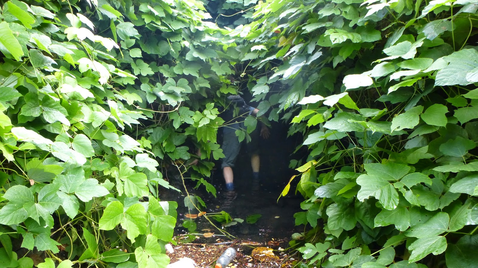
Will disappears into the kudzu

I should probably state right now, these are not the "prohibition tunnels" under Asheville. We are in a storm sewer under Asheville. So, why are we there? I spent the weekend with buddy, Will, at his Montreat home. Arriving very late Friday night, I learn Will has spoken with someone that evening at supper about first hand experience in the tunnels below Asheville. Earlier in the day, a group of 6 walked into these tunnels and spent a hour to an hour and a half. Upon hearing this, we just had to do this. We knew there were tunnels below downtown which had a prohibition connection. The tunnel entrance in Pack's Tavern is well documented and was part of a UNC TV documentary on the prohibition era in North Carolina. I've since learned, there are other entrances, some from credible sources and some are mere internet rumors. However, these tunnels have been collapsed in a number of places due to development and of course any entrances into buildings would have been blocked.

On Saturday, we found ourselves drinking a beer at One World Brewing. I asked Will how long did he think the girls would be at the nearby Chocolate Lounge. He replied, "long enough for us to go check out that tunnel entrance". So we gulped down the beer and headed to the spot we were told (vaguely, I might add) where the tunnel could be accessed. We were turned back by a plainclothes police officer at one point but waited until he was out of sight to continue. After walking around a bit, we thought we knew the general area but weren't dressed to get down in the creek and look closely.

Sunday, while visiting a couple "dive bars" in West Asheville, we run into 2 members of the tunnel group. Upon further quizzing, we learn we were in the right spot the day before. However, after processing some of the responses, I figure these are just part of the storm sewer system. Nevertheless, we can't let this adventure not be fulfilled. Early Monday morning, we are headed to Asheville. The unposted parking area next to a favorite drinking spot for homeless folks and a small creek is our destination. We wait until there is no one present and head down into the creek hidden by kudzu. 

Tunnel entrance

We are able to rock hop without getting wet, but we know we will be in water soon. Most folks who might want to do this will likely be rebuffed at this point. The creek enters a tunnel under the road. The sides are mostly stone but the roof is wooden timbers holding up some corrugated sheets of metal. It doesn't look like it will last forever. Right before and then into the tunnel, the water depth is between knee and thigh deep. This may be a deterrent to most. Once about 30 feet into the tunnel, the water depth becomes more manageable but still uneven and slick. After crossing under the road, the tunnel becomes mostly concrete and the water depth is only ankle deep. We are able to walk standing up. There is a collapsed cavity to the left side. I smell some bad air at this point but only for a few feet. We both have headlamps and Will carries a bigger flashlight. It is still dark and hard to see where you are stepping. We make a lot of splashing noise. When we come to a junction, there is concrete tunnel going right and metal culvert pipe going left. We take the right tunnel but after a very short distance, the tunnel becomes low and appears to be collapsed ahead. So we turn back and head into the metal culvert. This is easy walking as the water is just ankle deep and the height is about 5'8". 

Too low to continue ahead

I'm guessing we are in the metal pipe for 100 to 150 yards when we come to stone sided tunnel, seen below. This becomes narrow and then low. We see a pipe crossing the tunnel and we'll have to crawl to get by it. At this point we have been in the tunnel 20 minutes and may have traveled 2/3 mile. We're satisfied at this point and turn around.

Under downtown Asheville

I think the collapsed tunnel back at the junction was the original route of the sewer but when I-240 was build, it was abandoned and the newer metal culvert was used. Once we reached the other end of the metal culvert, we were back in original sewer. At this point, we think we were under Broadway and Woodfin. There were some manhole covers above in spots. We were afraid to push any up to see where we were since it would have been active roadways. At one point we could hear traffic, but mostly we just heard the echos of our splashing.

It was a fun adventure but I'm not ready to do it again.


Aug 31 Lookout Mountain


Looking north toward the BRP and the Craggies. Clouds fill the valleys but leave the mountains in the clear. 


This hike up Lookout Mountain is quite steep and needs much erosion control. I normally lag far behind Will on this and other climbs but not today. Of course it took a heart attack to make that possible. It won't be long before I'm lagging behind again.

Indian cucumber root

Aug 28 AT North from 19E


The club normally drives to the NC/TN border for a hike on Roan Mountain which either begins or ends on US19E right where the AT crosses the road. Today, we are hiking the AT north from this spot. Due to the lengthy drive and unfamiliar shuttle, we get a late 11am start. Nicole had enticed a few other members to scout this section for a possible future outing. Her "pre GPS" description said "elevation gain of 500 feet. I don't know why I thought 10.4 miles of AT in the Tennessee mountains would have only 500 feet of elevation gain but I fell for it. During the shuttle, Nicole clarified the elevation gain with the "pre GPS" tag. Of course, back in the 80's, that meant the low point and high point of the section were 500 feet different. 

We started hiking up. Easily we had 2000 feet of elevation gain before lunch. We learned later, the section we hiked had total elevation gain of over 3000 feet. 

The first half of the hike, went in and out of the forest, into open meadows. The trail was not as worn as I thought it might be. The trail made many turns and appeared to have been re-routed in a number of spots.  


Here is our second lunch spot by Jones Falls. These falls were very pleasing to watch. It made for a great side attraction to the AT. The water coming over the cascade would soon enter the Elk River. The photo below, shows us walking along the river which could be glimpsed now and then. It was just to the right of us but hidden by tall vegetation. 

Just prior to this, a nasty yellow jacket stung me on the ear. I had my epipen along and used it within a minute of two. I could feel the medicine going to work about 30 minutes later. My ear pounded the rest of the day but the swelling which had started to affect my neck, was held off by the epinephrine. On the return drive, I started feeling bad about 6 hours after the sting but once at home with a shower, benedryl and something to eat, I was ok. 


We came to another spur which led to Elk River Falls but did not take it. There was also another falls, Mountaineer Falls but it needed water.

The second half of the hike was mainly in forest. At one point, we were in a very dark rhododendron tunnel. 
We finished hiking about 4:30. So it was 5 1/2 hours to do the 10.4 miles plus the short spur to the falls. 


Aug 27 Bicycling on the A&Y


The trail still ends here at the tunnel under Rt 220. My ride was shortened today by an uncooperative derailleur. After riding I took it by Performance and saw how gummed up it was. My recent rides on the Greenbrier  and New River Trails kicked up a lot of tiny gravel and grit.

Kudzu is blooming

Apr 20 Waterwall on Walker Creek

  Waterwalls redirect floodwater back into the creekbed. There is one very near the Uwharrie Trail on the Walker Creek section. This one is ...