Monday, March 29, 2021

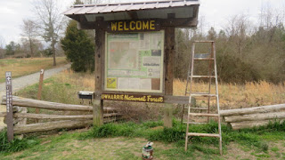
Mar 13 Uwharrie Trailblazer's Thornburg Trail Work Crew


With over 30 Uwharrie trailblazers ready for our workday, we split into 3 groups. Here is the Thornburg gang getting ready to head into the forest.


18 run outs and one cleared culvert were completed on the 1.8 mile trail.


the clogged culvert


fresh paint


Mar 22 Three Sisters Swamp


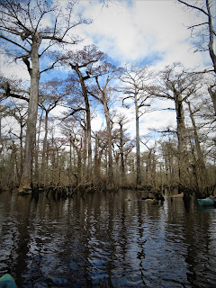
I'm holding a tree core mounted on a piece of wood. The core is from an ancient Bald Cypress - Taxodium distichum. Captain Charles Robbins presents an educational program before we embark on a paddle into the Three Sisters Swamp. The Bald Cypress have been here for a long time. It was not until the 1980s that it became apparent, they should be protected. The Nature Conservancy purchased some land outright and obtained conservation easements on other land. Dr David Stahle from the University of Arkansas, a dendrochronology researcher, was involved at this point but it wasn't until years later that he learned just how ancient these trees were and how extensive the area was. Charles Robbins also was involved early on. He had a long career of adventure and did some of the early exploring in the Three Sisters area. As things unfolded, he saw that the area of ancient Bald Cypress was 10 times the size it was originally thought to be. He guided Dr Stahle through the swamp and they began core dating the trees. The problem was that most of the big trees were hollow. Still alive and thriving but hollow.  


They could not get a core sample on a hollow tree. They went around the swamp, knocking on trees and just could not find any big ones to core. Around the campfire one evening, he had an idea. He made a long pole and started banging on trees up higher. Then he fashioned a ladder together so they could climb up a ways to where they could get a solid core. Not all trees were solid up there but some were. Suddenly, the oldest documented trees were older than they imagined. During my 2012 paddle here, the oldest documented tree began growing in 364 AD. Today the oldest documented tree began in 605 BC. It is certain there are older trees but no way exists to document their age.


The core samples do much more than tell how old the tree is. There is a couple thousand years of weather history there. One of the more interesting findings is that in 1587 the drought was the worst in over 800 years. Could that have forced the colonists of the Lost Colony to leave Manteo? 

The Nature Conservancy and others have now protected over 16,000 acres here. The Cone family from Greensboro owns a tremendous amount of land on river left. We paddled 12 miles today and every piece of land on our left was Cone property. 


After the presentation and shuttle, we shove off into the aptly named Black River. It is windy and a few gusts push us around but we manage to make good headway in the fast moving water.


The first 2 hours of paddling consist of Capt Charles talking almost nonstop. It is a mix of science, tall tales, anecdotes of a life of adventure, sprinkled with some sophomoric humor. 


We gather around Charles for a little pep talk before leaving the main body of the river and entering the swamp. The spot we enter is a bit further downriver than where I entered the swamp on two previous trips.


As we enter the swamp, we veer right and pick our way through a maze of trees and knees.


Brown Snake


Charles is quite comfortable in the swamp. He knows where he is all the time. As we float through, he calls out the numerical names of the core dated trees of note. The names all begin with "BLK" followed by a number. Some have a metal tag with that information on it. There is some controversy or mystique involving BLK069. The tree once credited with being the oldest could have had its tag switched or a duplicate made. Something is amiss. That tree was given the name "Methuselah". Personally, I feel that is a bad choice. That is the name of the 4850+ year old Great Basin Bristlecone Pine in California.


The leaves are just budding on the Cypress. We see lots of poison ivy and it is quite convenient to grab it when you need to get through a tight spot. The water is flowing and the wind is blowing. If you want to stop or take a photo, it takes some skill. The best way is to grab a knee and hold on. I ate my lunch with one hand holding on to a knee.

Hollow Tree

Holding on to a knee for lunch


The tops of these trees blew out a long time ago, maybe a 1000 years ago. They grow back and blow out again, giving them this odd appearance.


Oldest documented tree is center, missing its top.


Hollow trees and huge burls are the norm. There is also a phenomenon Charles describes when a tree is in distress, it produces small new branches on its lower main trunk. These branches provide new leaf grown helping the tree photosynthesize, possibly after branches or a top has been blown off.  


And what are the knees all about? No one is certain but if you could remove all the water and sand, you would see a network of trees and knees all interconnected as if the trees were clonal. They are not clonal, they are individual organisms but have interconnected, probably for stability. A hurricane might blow out a top but it appears rare that one is uprooted. 


This hollow tree was filled with 27 boy scouts according to Charles. I don't think the water level was that high that day. And maybe I heard that number incorrectly. It is a big one and you could get inside and it is a big space inside. 

Some new growth branches

We have been in the kayaks since pushing off at Henry's Landing. After lunch, Charles felt we needed a break. He effortlessly guided us to solid ground where we could get out for a few minutes. 


After two hours in the swamp, we emerge back into the main channel of the river and begin the final 6 mile paddle out. On three more occasions, Charles takes us back into swamps which provide short cuts from the meandering river. Several of these are also old growth areas. It was impressive to watch the ease at which he knew where to turn and how to emerge from the swamp.


Our paddle concluded after passing under the Rt 53 highway bridge. The rain had just started. 


Sunday, March 28, 2021

Mar 21 Ev-Henwood Forest


On our return from the Green Swamp Preserve, we stopped at this nature preserve not far off Rt 17. It has become an educational forest. Although the labyrinth of trails was confusing, we finally figured it all out. The scene above looks like a bare spot in the forest. It is an indentation which was a tar kiln. Tar kilns were used only once, so there must be hundreds or thousands of them throughout the Coastal Plain. This was the land of the Longleaf Pine. Once numbering about 90 million acres, now just a fraction of that. Tar, pitch and turpentine products were in high demand from England. Naval and cargo ships consumed these products, called naval stores, in vast quantities during construction and maintenance. 

The Longleaf Pine provided the resin needed. Many trees were tapped by cutting a v shape or box shape and collecting the resin for distilling into turpentine and other products. Others were cut down and burned in a slow smolder to make tar. Tar could be further refined to make pitch.

The kilns were circular, about 20 feet in diameter. At the bottom of the kiln, a hollowed out log or a metal pipe was used to collect the tar and deliver to barrels outside the kiln. The cut pine was stacked in layers with soil between each layer until it resembled the shape of a beehive. A thick layer of soil topped off the pile. Small holes were dug in the top layer so the wood could be ignited. The object was to smolder the wood for a week. Holes could be added or plugged to keep the smolder burning at a slow rate. Tar dripped from the smolder and collected in the middle where the pipe or hollow log collected it. 

Petrified Wood from the Cape Fear River


Mar 21 Green Swamp Venus Fly Traps


Our visit to the Green Swamp Preserve was a special one. I had never seen a Venus Fly Trap in its natural habitat. It didn't take long to spot one. Once you knew what you were looking for, there were dozens in this small area.

Can a Venus Fly Trap count? Look closely at the structure of the plant. A clam shaped trap has a series of sensitive hairs. When a hair is contacted once the plant prepares to close its trap but only after a second contact is made within about 20 seconds. If that occurs, the trap closes. Then the digestive process does not start until 5 more stimuli have occurred. All of this insures that the plant has caught some prey and is not expending energy unnecessarily. 

It takes about 10 days to digest its prey. At that point the trap is reset.


Just a little over 3 months ago, on Dec 9, 2020, this area was part of a controlled burn. It is coming back in a very vibrant way.


Sundew is a bit smaller than the Venus Fly Traps but has a very colorful personality.


There is a trail here but it turns to swamp which we were not prepared for. 


Sunbonnets - sometimes called Pineland Daisy

Late year's Pitcher plant remains

Flowering Pixiemoss


Tuesday, March 16, 2021

Mar 14 Sauratown Mountain Hike


I was not aware of a trail leading up Sauratown Mountain until Will mentioned one. The plan was rather open-ended. We would meet at Camp Hanes, look for a trailhead and see what was there. He had a vague idea that we could reach the top by heading up and going right along the base of the cliff.

The trail was in great shape. There were lots and lots of rocks but the trail had been professionally done and was easy walking albeit uphill. 

As we reached the midway point and crossed a small creek, we saw a sign but it was not facing us. We felt it must have been part of an earlier trail. 


When we reached the base of the cliff, we could see that it was a vertical wall both to the right and left. We wandered around for a bit and determined that we might be able to head up through a gap in the wall. It looked doable but once I had gotten partway up, I could see that we had a very long way to go and it was not going to be safe. After turning back, we ran into some climbers and chatted with them for a few minutes. They didn't know if a trail went to the top or not. They did point to a rope embedded in the wall and said we could swing over this abyss and the trail continued. Maybe 20 years ago, we would have taken this route but we suffer from age now.


Back tracking a bit we found a well worn path which headed along the cliff base going left or west. We followed this and ran into several groups of climbers. Everyone told us, the trail got rough but none of them knew if it went to the top.


We pushed on through trail which had been recently cleared but still a scramble in many spots. There was one place in particular, we slid down one at a time in case rocks were dislodged. I didn't think we'd be able to go back up that spot, so we'd have to find another way back.


It seemed a long time scrambling along the base. Then we made an abrupt turn and saw a sign with "11" on it. No clue what that was about. Now the path was more obscure and choked with greenbrier. Devil's Walking Stick was strategically placed here too. Suddenly, we had a nice view and could see one of the communication towers right above us. It looks like a short scramble through more greenbrier. We popped out on top between two towers and near the end of the gravel road on top. Clearly, this was a gated road as we saw no traffic on it for the 30 minutes or so we were on top.


It's gnarly in spots

Almost on top

That's Pilot Mountain out there

We ate lunch with a grand view. We could pick out the cities to the south and some of the Uwharrie peaks. To the west, we could see a few peaks but probably not as far as the Brushies. To the north, the Blue Ridge was in view with easy to identify Bull Mountain.


This building has a chain-link fence around it. There was also a stone wall just outside the fence which we were able to walk on to get past the building and drop down to the final tower on the mountain.

Covington Mtn Fire Tower

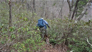
We had picked out our route while sitting for lunch. It looked much easier than it turned out. We entered a rhododendron hell which had greenbrier to boot. As we thrashed through the thickness, Will said "it is kind of a sickness, but I like this stuff". 

A Rhodo hell

We crashed our way down to open forest and eventually found ourselves on an unmaintained trail which had recently had some minor clipping done. This led us to an old stone foundation and eventually to the maintained trail. From there is was a simple walk back out to Camp Hanes.

Old foundation

Nice rock work for hiking


Apr 20 Waterwall on Walker Creek

  Waterwalls redirect floodwater back into the creekbed. There is one very near the Uwharrie Trail on the Walker Creek section. This one is ...