Monday, November 30, 2020

Nov 29 The Willow Oaks Walkabout


Kevin Redding of Piedmont land Conservancy organized this walkabout on a recently acquired property. A small gathering met roadside to walk in on a narrow strip of the property, sandwiched between two adjacent landowners. Despite downloading maps of the property on Avenza, we manage to walk way off onto the adjacent land before correcting our error.


Once back on the property, we began our tour. Early on we stumbled upon some farm dumps, including rusting hulks of farm machinery. The forest varied from scrubby mismanaged thickets to mature hardwoods. The forest had been cruised and marked for timbering. Many of the trees bore the telltale blue slashes of those that were to be taken out. Those trees earned a reprieve when PLC purchased the property, trees still intact. 


Old timber roads can be found throughout. There is a well worn 2 track creekside. The creek is Little Carraway Creek. At one point a steep hill comes right down to the creek, covered in Mountain Laurel. That spot is too steep for the creekside 2 tract to slip through. See above.

Mt Shepherd 

Mt Shepherd, the highest point in Randolph County is often seen in the near distance. Elevation is listed at various heights between 1150 and 1157 feet. It may not be visible at all in the summer with leaves out.


The creek and old dam are the main attractions. The dam is very well constructed with huge stones. Check out the lintels over the tunnel outlets. I've read that this type dam is a water fence. Their purpose is to slow the water flow so silt can settle out. The design is not to impound water nor to power a mill. The center of the dam is built lower than the sides, presumably to speed up the velocity of the flow and redirect it into the creekbed during floods.


After viewing the dam, we followed the creek until the topography got too steep to continue. There was much debris in this area. Lots of plastic and glass waste littered the area.

We encountered a massive Shortleaf Pine in this area. It had a large low branch indicating it was in an open area when it was young.


Our crew follows an old road headed to the dam.


Crown of the Willow Oaks

Very impressive to me, were the number of Willow Oaks on and near the property. There were several massive ones on top of a knoll which would have had a view when it was open. There were a few bushy Eastern Red Cedars here as well which would indicate it was open at one time. 

The Willow Oaks

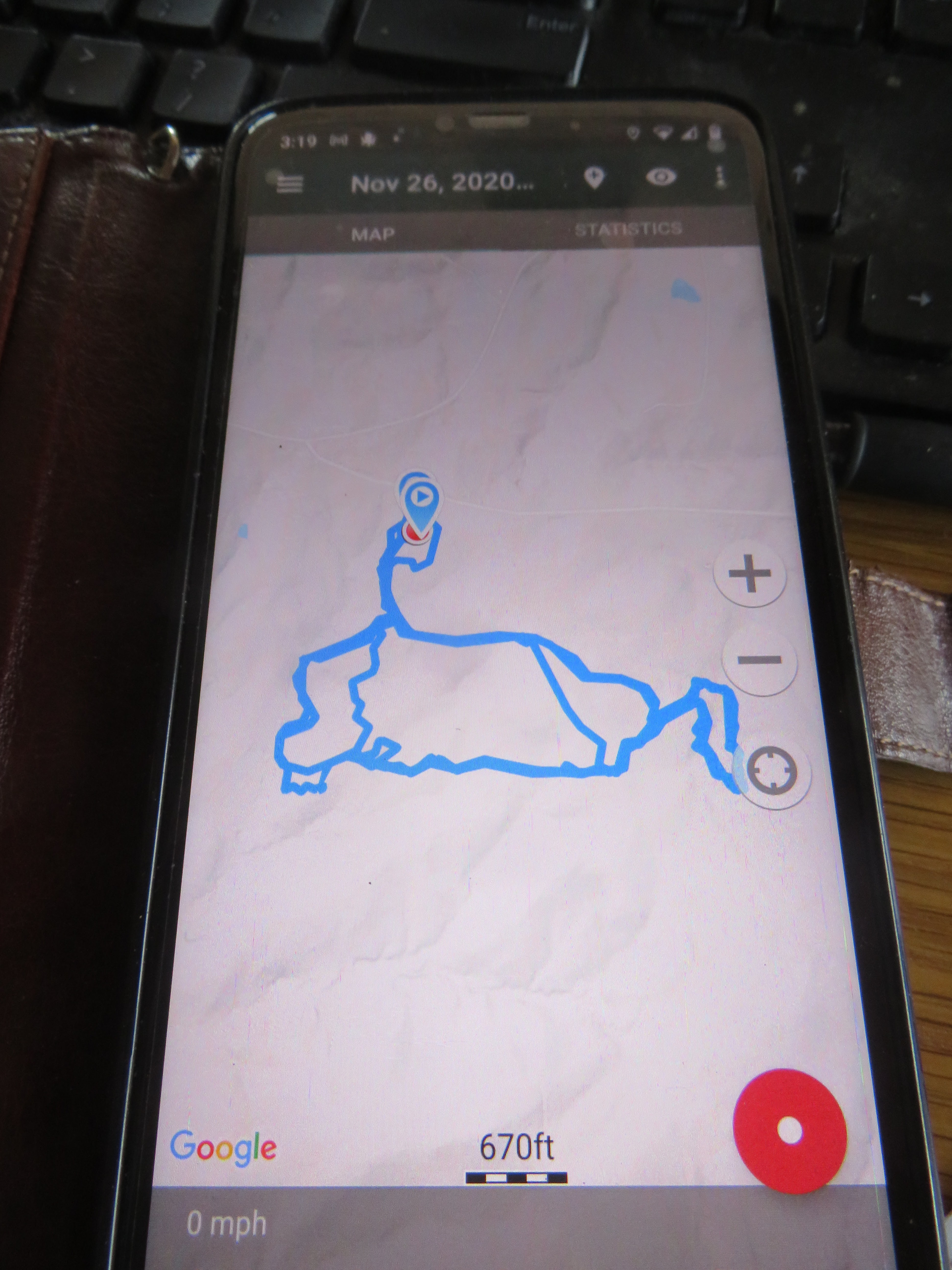
Many thanks to Kevin for inviting me. I enjoyed the 3 1/2 mile jaunt  around the property.

Friday, November 27, 2020

Nov 27 TRLT Outdoor Challenge Day 27

 Camp 3 Trail Work Day


Early morning fog at Coolers Knob

Split Rock


The last day of the Three Rivers Land Trust's Outdoor Virtual Challenge. My goal is to reach 200 miles and I need just over 7 miles to do it. I tried to keep my miles on hiking trails but I did amass about 6 greenway garbage miles in the process. And visited several new hiking venues. Visited some ones I have not been to in a while, as well. Today is a working hike. I have my saw with me and got to take it out of its sheath 5 times.

Lions Mane Fungus


I could not clear this one completely but you can easily step over the trees on the trail now.


This is one of the blowdown the SAWS crew took out last year. However, one of the overhead branches has sagged down low enough even I have to duck to get by. Perhaps the one branch above will sag over time too. 


Nov 26 TRLT Outdoor Challenge Day 26

 More Hiking & Birding at One Tree Hill


Nov 25 TRLT Outdoor Challenge Day 25

 Zoo's Hiking Trails


We're hiking the Zoo's trails again. We wanted to access the trails from the new Woodell Country Rd trailhead. The Zoo has build a very attractive trailhead there. However, upon reaching the road, Posted No Trespassing signs deter us. 


After hiking all the way out MIddle Mountain Trail to the new trailhead, We looked at the sign at the road and see the road is private beyond the trailhead.


At the end of Moonshine Run Trail, flagging disappears off in the woods, marking a future trail route. I understand a workday is coming up for local honor students to help build trail here.


Nov 24 TRLT Outdoor Challenge Day 24

 Birkhead / Camp 3 Loops from Thornburg Trailhead


Another way to hike the Birkhead loop. Today I'm hiking from Thornburg and incorporating the Camp 3 nd Birkhead loops with a twist. Once again I'm taking the Old Road Trail.


Camp 3 Trail is much easier to follow than it was a few days ago. The fresh leaves have been trampled a few times and now easy to see where the trail goes. I cut a better path through the massive blowdown near Split Rock.


As I made my return on Thornburg Trail, I could hear the thud of axe blows. An old fellow (older than me) was blasting his axe through a huge Red Oak which has been in the trail for most of this year. Thank you sir.


The bridge over Betty McGee Creek took another hit last week. It is still serving as a bridge but for how long?


Nov 23 TRLT Outdoor Challenge Day 23

 Raven Rock State Park Hiking


I intend to hike all the hiking trails east of Campbell Creek in the park. Campbell Creek creates a border. There is no bridge on it near the Cape Fear River, so the park trail system is divided to east and west of the Creek. First trail is the Northington Ferry Trail. It has a memorial headstone about halfway out. The trail ends at the confluence of Campbell Creek and the Cape Fear River.


Next up is the Fish Traps Trail. It descends to the river on this magnificent staircase. The trail goes to the river and then follows it a short distance to a viewpoint. This section washed out recently and is closed. The river was up too high for fish traps to be visible anyway.


Back on the Raven Rock Trail, this is the scene from the overlook. Then it is down the long narrow staircase to the bottom of Raven Rock. I had a long wait at the top waiting for a couple to slowly make their way up. 


Next trail is Little Creek Loop trail. It starts out as a ridge walk with very limited river views. Then it turns to follow Little Creek. This is a delightful creek with a solid rock bottom. It cascades and forms several sliding rock opportunities. 


Finally I'm on the bike trails, hiking the opposite direction as the bikes are supposed to ride. The sign says this alternates each month but I don't know how the sign is changed to indicate this.


Apr 20 Waterwall on Walker Creek

  Waterwalls redirect floodwater back into the creekbed. There is one very near the Uwharrie Trail on the Walker Creek section. This one is ...