Tuesday, June 19, 2012

June 16 Bicycling Cades Cove


On Wednesday and Saturday morning during the summer, the Cades Cove Loop Road is closed to motor vehicles until 10 am to allow bicyclists and walkers/joggers to enjoy the loop traffic free. I was able to get started on both Wednesday and Saturday slightly after 6am for a couple laps around the 11 mile loop. The parking area fills quickly so it is advisable to begin early. 


On my 4 laps I was able to see 3 bears and dozens of deer. The bears quickly move away from you but the deer often don't show any inclination of doing so. There is also a sizable turkey population here. They are sometimes hard to spot in the high grass. 


I believe these are Jack O Lantern mushrooms growing at the base of a dead red oak.


Wildlife is one of the big attraction in Cades Cove. I was not disappointed. Here we have the usual suspects - a bear and deer.


June 15 Cooper Road and the Super Bloom


Driving and hiking through the park this week was a real treat. The Rosebay Rhododendron seemed to be everywhere. Every bush seemed to be blooming. The GSMA is calling it a hundred year Super Bloom. I suspect it has something to do with the absence of the hemlock trees. Hemlocks are dying throughout the park and exposing the understory to lots more sunlight than it has ever seen. Hemlocks and rhododendron like similar terrain along creeks. 

Cooper Road Trail is accessed in the Cades Cove loop. The trail is a driveable road. I walked an out and back route of 11.2 miles. Today, park service rangers were doing maintenance on the trail. They rode horses and three ATVs, a John Deere, Cub Cadet and a Kawasaki. If that didn't stir up the yellow jackets, the weed whackers surely did.


The Rosebay display was unparalleled. For much of the trail, I was creekside and in a sea of white snowball blossoms. The scene above was repeated many times, as far as you could see.


This trail was impacted by the tornado which ripped through this area a little over a year ago. Several other trails remained closed. What was once a forest scene, is now a open area of tangled wood and lots and lots of new ground vegetation. Keeping this new vegetation down is going to be a challenge.

This trail added 5.6 miles toward my S900 Challenge. 

June 14 Andrews Bald


In 2008, the Friends of the Smokies, through their Trails Forever program, rehabilitated this formerly rocky, rough trail to a super highway of trails. The trail work is outstanding. Presently, Chimney Tops Trail is undergoing a similar makeover. 


Clingman's Dome parking area was crowded as usual and shrouded in fog. I quickly escaped the crowds on this 1.9 mile trail that only a fraction of the visitors will venture out on. Immediately I am intrigued by the odd round marks on the rocks. They look as if some has carved a series of various sized circles. One such display looks like a mural of natural randomness - several circles and an odd shaped torpedolike image.


Unlike Gregory Bald, Andrews Bald sports Flame Azalea only. There are some shades and a few with patches of yellow but it is predominately a one color bald. Andrews appears to have grown back more than Gregory. The main part of the bald is open grass and azalea but the fringes are a mixture of returning trees and grass and azalea. Today it was foggy so no view but the flowers were sufficiently engrossing.


June 13 Lead Cove-Bote Mtn-Finley Cane Trails


This 9.4 mile loop with a side hike was a fairly easy walk. Going up Lead Cove trail was a bit tough in the heat and humidity. I spotted one bear in the rhodo along here. Once at Bote Mountain Trail, I hiked an extra 2.4 miles to complete an unhiked portion of that trail. Bote Mountain Trail is a wide two track with few redeeming features. The final leg back is along a very pretty trail, Finley Cane Trail. there is a small patch of cane along it. 

With about 2 miles to go I stepped over a freshly fallen tree and immediately felt the unmistakable sting of a yellow jacket. I think he got me twice and maybe a third time. I thought it was a good time to break out the Epi pen. I tossed my pack on the ground and unzipped. Just as the pack was opening I realized I had transferred the Epi pen to my bicycling gear that morning for the ride around Cades Cove. Fortunately, the trail was fairly level for the last 2 miles. I walked as fast I could, feeling the stinging sensation more and more as I went. It took about 40 minutes and I finished strong so no ill effects from the stings. Damn yellow jackets.

This hike added 8.2 miles toward my S900 Challenge. 

June 12 Gregory Bald Azaleas

Pink

My two previous hikes to see the the Gregory Bald azaleas were on the Gregory Ridge Trail and the Gregory Bald Trail. I chose to hike up from a different direction today, mainly to try something else and add mileage toward my S900 Challenge. The route from Twentymile Ranger Station can be done as a 15.6 mile loop. I started up Wolf Ridge Trail and came down Long hungry Ridge and Twentymile Trails. Hike bagan about 6:15am in fairly cool but very humid conditions. Coolness gradually wore off to warm and then hot and humid. I was drenched in sweat after just a couple miles. Wolf Ridge Trail is unrelenting for its 5 mile course. You do get a break upon reaching Parsons Bald. Here the trail is very narrow and with grass and other vegetation drooping into the pathway, my pants got soaked. I zipped off the bottoms and put on gaiters which I should have done 5 minutes earlier. Nevertheless, the gaiters worked fine from this point on. 

Flame

It is a short uphill walk from parsons Bald to the backcountry campsite at Sheep Pen Gap. The fog was so thick here I could barely see 10 feet. It was eerily quiet as I passed through this ghostly fog. I met three backpackers along here. They were doing the same route as I but over a 4 day span - how relaxing I thought. They did mention that it rained everyday and last night was very wet. Judging by the condition of the trail, I agreed.

There was no one at the backcountry campsite. Odd, this is azalea season and it should be overflowing with campers. Even odder, I met no one else on the bald or on the trail all day. I learned later, Forge Creek and Parsons Branch Roads were closed thus severing easy access to the bald.

The trail from Sheep Pen Gap up is very muddy. I saw what looked like a monster footprint in the mud. Actually, all the half mile up, I saw this bear's foot prints. As I reached the bald, a certain excitement fills the air. The show is about to begin.

Red

The wild azalea most associated with the Smokies is commonly known as Flame Azalea. It is the color of a burning flame and is often seen one bush at a time in the forest. You can often detect some slight color variations but basically it is orange. Here on Gregory Bald several other native azaleas have hybridized to display a broad range of blooms. Dominant are the reds and then the flame orange. These are found in many shades and folks have tried to color code them with all sorts of variants of orange, red pink etc. Throughout the bald you will occasionally see pink, white and other variations as you walk about. Today I did not find a yellow bush but have on a previous trip. I did see some white blossoms with yellow centers and salmon blooms with the same. It is a real treat to walk through the bushes for an hour or two and see the surprises. 

White with Yellow 

At 4949 feet, you are about 3000 feet above Cades Cove. The view, although not today, is spectacular with Rich mountain in the background. Gregory Bald is named for Russell Gregory, an Irish immigrant and Cove resident who tended cattle on the bald up to his death during the Civil War. He resided in a stone hut in the bald.

At that time there was over 20 miles of continuous bald. When cattle stopped grazing on the balds in the 1930's, the balds began to grow back. The Park Service is maintaining only 2 of those balds today. Gregory and Andrews are maintained by mowing the grass. A volunteer crew hauls gasoline up to the bald and mows with a self propelled mower a couple times a year.   

Candy Stripe

After traversing the bald, I head down toward Long Hungry Ridge. Shortly, I realize I am dehydrating and start drinking fluids. It is easy to refrain from drinking while walking downhill so I purposely stop every half hour or so and take on more fluids. When I reach Twentymile Trail, the final 3 miles is on a driveable road and the walking is easy. Somewhere along here I lose my longtime hiking companion - my walking stick. I'll need to make another.

Salmon with Yellow

Today's hike added 14.5 miles to my S900 Challenge. 

June 10 Bruschetta


I've made this recipe a couple times. It is a wonderful mix of flavors. Go easy on the red chili pepper, it can really add some heat.


June 8 Pizza


I've finally settled on a dough of half whole wheat and half white flour. The experimentation with semolina flour has ended. Today we made 2 pizzas with about a pound of chopped chanterelles, a couple Italian sausages from Giacomas and spinach added after baking.

June 7 Birkhead Chanterelles


These are some of the largest chanterelles I've encountered. I followed a creek and kept finding nice colonies. This harvest began with 3.5 inches of rain over a 2 day period. The harvest lasted about 8 days with one inch of rain during the harvest. My haul was right at 20 pounds so there is a lot in the freezer.


Wednesday, June 6, 2012

June 5 Transit of Venus


Friends of Sauratown Mountains and Forsyth Astronomy Club gathered atop Pilot Mountain State Park for an event referred to as "Transit of Venus". The planet Venus passes across the sun. One might think this event is an annual one but it is not. Since the invention of the telescope in 1610, there have been only 8. The next one occurs in 2117, that is 105 years from now. So if you missed this one, as we did, you're out of luck.


The "Friends" invited members to come to Pilot Mountain State Park to witness this event. Cloudy conditions held the numbers down. Still we had a pleasant evening with some great views toward the Blue Ridge.


Astronomy club members had all sorts of telescopes set up including this home made viewing contraption. Made completely with material purchased at Wal-Mart, it was designed to project an image of the sun with Venus, on a shower curtain stretched across a large flower pot. During the event which lasted from 6pm-8:30pm, there was a window of a minute or two when the sun popped through the cloud cover and ever so briefly a few scopes were able to focus in on the target.


Monday, June 4, 2012

June 3 Three Top Mountain Scramble

Having been turned away on two previous occasions due to forecasted wet weather, today was the big day to traverse the ridge of Three Top Mountain in Ashe County. Three Top has  a recognizable profile of three abrupt  peaks. However, if you study the mountain and its surrounding area, the ridge includes a couple more peaks which don't figure into the equation until you attempt to traverse this ridge.  Our leader, Marshall Weatherman had researched previous traverses and received a gpx file from a friend. This file provided the planned route for our outing. Despite having all this data and maps, we knew it would be a challenging day.


Three Top Mountain in Ashe County is not to be confused with the Virginia mountain with the same name, used as a signal location during the Civil War. Our Three Top Mountain is the largest continuously forested tract in the county. Most of the mountain is property of North Carolina Wildlife Resources or NC Game Lands as everyone refers to it. There are several access points but really only a couple are suitable for accessing the ridgeline. We have chosen two which begin and end on either end of the ridge.


Our group consists of 10 veteran Piedmont Hiking and Outing Club scramblers and one newcomer, my buddy Will Truslow.  Throughout the day there was not a complaint or serious disagreement. Everyone helped each other traverse the tough spots. We stayed together, never getting out of contact with the fellow in front or back. We joked when appropriate and proceeded with caution when appropriate. No one was injured. We all had a great time during a very difficult scramble.


Our initial plan is foiled upon arrival. The access road is steep with loose gravel. Oddly, only the little Corolla is able to make it. The two other vehicles need to be pushed. A quick assessment of this situation leads Marshall to alter our plan, actually just reverse it. We decide to shuttle everybody up to the next access reverse our hike. By doing this, we avoid having to drive up this loosely graveled road again.


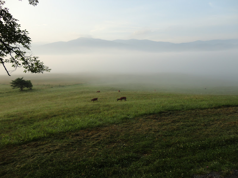
Once again on the next access road, we are forced to bail out of the vehicles and push them up the hill. Now we are ready to begin hiking. The trail is slightly downhill and level for the first 10 minutes. Then we begin a very steep trek up an ATV two track. This goes on with little relief until we attain the summit of Huckleberry Rock, about 50 minutes later. We made at least a half dozen stops to huff and puff during this ascent. We fear that was the easy part.


The view here is spectacular. Several guys make their way out to a distant rock outcrop to better scout the route we'll be taking. Surprisingly, with all our preparation, we are 180 degrees off. It turns out after some realization, we are looking the wrong way out the ridge. It takes me about 30 minutes to re-orient after learning this. Looking at the maps now, it all makes sense but I was really turned around. For some folks that wouldn't faze them, but it bothered me.


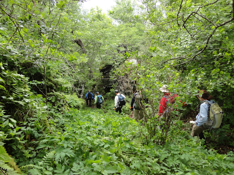
To begin the bushwhack of the ridge, we needed to retrace our steps back a quarter mile or so and just look for good spot to follow the ridge. We had Marshall's GPS guiding us but still required some common sense and deductive reasoning. We entered the forest and strode through a rich under growth of vegetation. There was a semblance of a trail. On and off all day there was a semblance of trail or animal path. Occasionally we spotted some flagging but it was far and few between. Our first destination loomed high above - Big Rock. The scramble was tough in spots but for the most part it seemed to follow a faint manway. When we did attain the summit of Big Rock we were rewarded with stunning views. We found a very exposed place to sit for lunch. You can't get a table with this view anywhere in the world. My PB&J sandwich washed down with lukewarm water was great.


Immediately after lunch our first big challenge arises. The route off the rock we are on, looks poor in every direction. At this point, newcomer Will, has been guiding us with some direction from Marshall's GPS. Will scouts a route down the right side of the rock. It takes everyone a while to manage their way down this rock. From here things get interesting. Without any discernible route we manage as best we can to scramble this way and that and somehow make our way down to a saddle and begin the scramble up to Peak 4880. This one proves very difficult. We are assaulted with wind and some rain. Fortunately the rain is short lived. As we make our up, we grab whatever will hold us. Some complain of a thorny bush. I believe this is Prickly  Gooseberry, a shrub only found in the mountains and on the Elk Knob taxa list. With thorns on the woody stem and leaf stems, it proved a point to those not wearing gloves (As a former glove manufacturer, I feel it my duty to point this out). We manage to make it to the top of 4880 and now must descend to another saddle and ascend to peak 4770.


We are still in very challenging terrain. there is lots of slipping going on. In one spot my throat fills with a odd taste. Shortly thereafter several of us start coughing. Deanna suggests we are stirring up stuff that hasn't been disturbed in quite a while.


Peak 4770 is anticlimactic. There is a very limited view and we have to take turns to see it. From here we retrace slightly to a ravine and head down for our final descent. It is about 2 miles to the car and we are in a rich forest but we have no reference points other than the GPS. I'm glad we did not start in this direction. We are wading through a sea of nettles, some are stinging us through out pants. Finally we arrive at the car and mange a change of clothes and shuttle before the drive back.


One thing we decide is we'll do this as an out and back scramble in the future. The scramble beyond Big Rock didn't warrant the reward. I'm glad to have traversed the ridge but will modify the route in the future.

Marshall Weatherman's Photos of this hike

Friday, June 1, 2012

May 31 Chanterelles


Roughly 1 1/2 hours of foraging today yielded about 2 lbs. Mushrooms are a bit dried and could have used another soaking rain about one week ago.


Apr 20 Waterwall on Walker Creek

  Waterwalls redirect floodwater back into the creekbed. There is one very near the Uwharrie Trail on the Walker Creek section. This one is ...