Thursday, March 28, 2024

Mar 26 Check Dam on Taylor Creek


Another dam in the Caraway Creek drainage is one that many people have seen as it is visible from Lassiter Mill Rd. The owners on creek right have a concrete walkway and patio (with red chair) showcasing the dam. They generously allowed us to access the dam. This one appears to have a 55' spillway with wings or spillway abutment walls on either side. Wing on creek right I estimated at 50 feet and the other side 35 feet. The creek right wing turns sharply back in the last 10 feet.  Wings are about 3 feet high. The dam is 12 feet thick and has about 12 feet of freeboard. 


The outlet is partially clogged on the intake side by debris. This may cause the water to rise up as high as the wings. Also, much soil has been deposited on the sloped side of the spillway, allowing Privat and Poison Ivy to take over. There is a bed of Poison Ivy on both the wings and spillway.  


A beautiful plunge pool has been carved out. This make a great swimming hole. It may have been formed or redone more recently. There were many rocks piled up on creek right that looked as if they had been deposited there more recently than the construction of the dam.


The owner stated twice that the noise when the creek flows over the dam is deafening.


Mar 25 Hickory Creek Access of Mayo River State Park


Today's hike is on the Hickory Creek access of Mayo River State Park. I'm with a couple friends exploring. For me the best discovery is the Snakeskin Liverwort above. It was a large patch growing on a vertical creek bank along Buffalo Creek. It must have been residing there for quite some time. Poking my finger in it revealed a firm spongy texture. It is not a vascular plant with veinlike tubes which carry moisture and nutrients. The leaf like structure is a thallus. It is made up of polygon shaped bumps with an air pore in the middle. Looking closely it resembles a snake's skin.


We explored 3 creeks, Hickory Creek, Buffalo Creek and an unnamed one between them. All three have lovely rocks with cascading water surrounded by mature forest. We also walked alongside the Mayo River to access all three. Much of the property we saw today is owned by Piedmont Land Conservancy and is slated to transfer to the state in a few years. Mayo River State Park has been built piece by piece as land becomes available. Just across the border of Virginia, another Mayo State Park (Virginia) exists.  


This hand hewn cabin was someone's home once. Daffodils have naturalized around the structure. 

Big Rock in a bend of Hickory Creek


We came upon a stone foundation with this stone vent. An early tobacco barn was the consensus. We saw a second one near the parking area that had the same stone vent but also had part of a gas burner nearby. 

Possible tobacco barn foundation.


Sourwoods grow in odd ways but the one has taken that to a new level. 


Deer hunters will love this elaborate stand complete with staircase and railing. 

Serviceberry in bloom. Maybe that is Sassafras in the foreground


Mar 24 Haw River Trail at Sellers Falls


The newest section of the Haw River Trail is from Sellers falls or mill to Red Slide Park. It is a 4 mile track which also serves as the Mountains to Sea Trail. The hike began at the entrance to Stony Creek Marina just a few minutes from Burlington and Graham. There is a small parking area and port-a-john just outside the marina gate. The marina is only open Friday and Saturday so parking is limited to this small lot the rest of the time. The marina is on a tributary, Stony Creek. It is backed up by a dam here forming Stony Creek Reservoir. The dam is located a couple hundred yards from the confluence with the Haw. 

From the parking area follow the MST signs into the woods for a nice wood walk with nice patches of Mayapple before crossing Carolina Rd and Carolina Mill Rd. The Haw River Trail is sandwiched between the river and Carolina Mill Rd, right in the litter zone of that road. There was trash and lots of broken glass in the trail. This trail has been hacked out of a thicket of small trees, Privat and briars. It is also uneven being in a flood plain that had flooded back in January. 


After a short distance, the trail heads onto the road to get by a massive mill, formerly Copeland Fabrics. After about 1/2 mile the trail is back next to the river. This time it is between the river and a gas pipeline. Through here, the river has several ledges separated by flat sections. It looks like a lively paddle with  frequent ledges. 


After seeing so many wildflowers at White Pines Preserve, I expected a similar treat today but that was not the case. The flood plain was overgrown with small shrubs and only supported a few wildflowers.


Although the trail was getting more scenic, I was running out of time and turned back before the trail got into a wooded area without homes on either side of the river. Time to turn around.


Copeland Fabrics mill is ahead

Wednesday, March 27, 2024

Mar 23 White Pine Preserve Spring Blooms


This gem of a preserve is located at the confluence of the Rocky and Deep Rivers just south of Pittsboro NC. Over 200 acres were conserved by the Triangle Land Conservancy in 1986. I've read it can be 10 degrees cooler here than Pittsboro. The microclimate has survived for thousands of years. It is believed many cooler weather plants remained here after the last ice age receded. Although we did not see any, Dutchmans Breeches, Catawba Rhododendron and Catesby Trillium are found here. White pines too. 

Early Saxifrage 

Purple Violet

Dead Nettle

Rue Anemone 


Next to a homesite is this cellar structure with steps leading into it.

Star Chickweed


Yellow Buckeye

Violet Wood Sorrel


Saturday, March 23, 2024

Mar 22 Birkhead Area Homesites & Dassow Tract Ribbon Cutting


In my wanderings and forages through the Birkhead Wilderness vicinity, I often come across homesites. Typically, a chimney fall or intact chimneys are a dead giveaway. Other characteristics are wolf trees (large trees with with low branches that grew in a yard), yucca, daffodils and other ornamentals, large Eastern Red Cedars and ground disturbances. 

Arriving an hour early for the Dassow Tract ribbon cutting, I wanted to get in a short hike to a nearby homesite. This one is on a small creek. There is a standing chimney, for now anyway. A spring was located about 60 feet away. There were no other typical homesite characteristics. And, I could find no sign of an old road to access the place. I walked in circles around the chimney but never found anything. This homesite is quite close to the Dassow Tract, probably just a couple hundred feet away. 


A flat lintel bar holds some hand formed bricks in place as the fireplace's lintel. 


I'm beginning to document these homesites in the Birkhead area. My current tally is 20 homesites and Gray Owl which is still standing. There are a couple more suspected spots. Only 2 have standing chimneys. 


After a brief visit, I headed back to the trailhead to socialize with the ceremony participants. District Ranger Susan Ladd Miller spoke and was accompanied by Rodney Smith, Corey Ledbetter and John Langdon who has assumed Terry Savery's Trail Specialist duties until someone can be hired for that position. Three Rivers Land Trust had about 6 staff present and there was a smattering of others. 


The ribbon cutting ceremony was for a 99 acre tract being transferred to the Forest Service. The Dassow family owned this land from 1970 until 2019 when Three Rivers acquired it for the purpose of transferring it to the Forest Service. During that time, hikers have hiked across the property via the Birkhead Mountain Trail which passes through it and  hunters have accessed it as well. We are all so thankful for the Dassows' generosity in allowing this recreation on their property. A planned timber cut was the wake up call for local conservationists. I credit Crystal Cockman of TRLT for orchestrating the fundraising needed for this purchase and transfer. David Craft and Mary Joan Pugh also played roles in conserving this land.  A plaque in honor of the Dassows is embedded on a rhyolite outcrop near the top of Coolers Knob. Crystal Cockman of TRLT led a hike past the plaque and on to the top of Coolers Knob. 


Tuesday, March 19, 2024

Mar 18 Three Dam Hike on Little Caraway


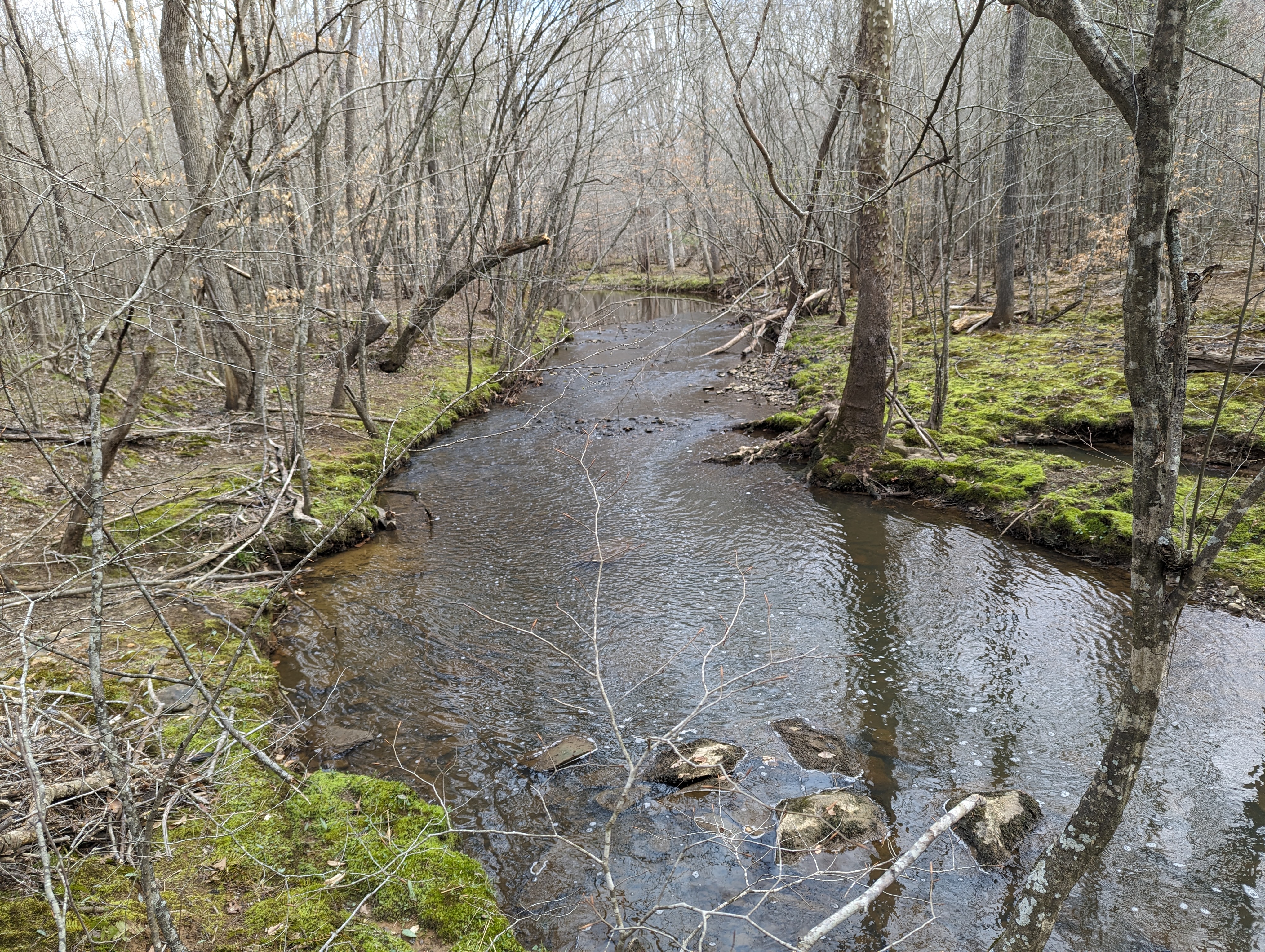
Little Caraway Creek enters a tight gorge here. The flow of the creek becomes lively and the creek is punctuated with many rocks. Both floodplains have been scoured by a January rainstorm. 


The flooding left the floodplains open, allowing moss to grow and give the creek a colorful appearance.  


This troll tree Sycamore has an extensive above ground root network. 


Will and I were both in awe of the beauty of the section of the creek. We were not here because of that. We were looking for another Caraway drainage check dam. Satellite imagery showed something across the creek in the area. It was a long shot being a dam but the beauty of the creek would have been enough to visit this area.  


The creek continued its picturesque journey. It was easy to walk with the floodplains having been cleared.


Then, it appeared. A 150 foot check dam with one outlet, 3 foot high wings and probably the thickest wall we have seen yet. The rocks appear to be larger than most dams we have visited. And this may be the highest we have seen as well. Its sides are anchored well giving this one a chance to survive. Many we have seen have been breached, usually on an earthen end. 


The creek flows through the one outlet at grade unlike others.


The slope is similar to other Caraway drainage dams. There are huge flat rocks held in place by mortar. The only mortared place on the dam. 


upriver side of the dam


I don't understand why this outlet is not blocked by debris. There was just this small amount of debris here. Almost immediately upcreek, two branches flow together.  


After a lengthy visit, we turned back to head down river to this check dam. We have visited this one before. It is 200 feet with one outlet (possibly a second has collapsed). It has only one rock wing, about 5 feet high. The other side is wingless but the land slopes upward creating a second wing. It is well anchored in rock bed. We are 1/2 mile down creek of the first dam.


About 3/10 mile from the second dam is another one. It has been breached and has suffered some other damage. One outlet, 5 foot wings and just over 100 feet. It is well anchored in rock bed on the side still intact but the other side has blown out and the earthen bank has been cut away. 


back side


The creek now flows freely around the blow out.


Orange Rock Hair looks like spray paint.


Little Caraway flows into Caraway at an unusual angle. Walking down creek on Little Caraway, you see the Caraway Creek Preserve's dam straight ahead. Little Caraway enters Caraway flowing into Caraway's flow rather than with it. Just below the forks is a ford which we used. This is possibly where the Indian Trading Path crossed Caraway.  


Apr 20 Waterwall on Walker Creek

  Waterwalls redirect floodwater back into the creekbed. There is one very near the Uwharrie Trail on the Walker Creek section. This one is ...