Monday, December 11, 2017

Dec 4 Dog Sledding


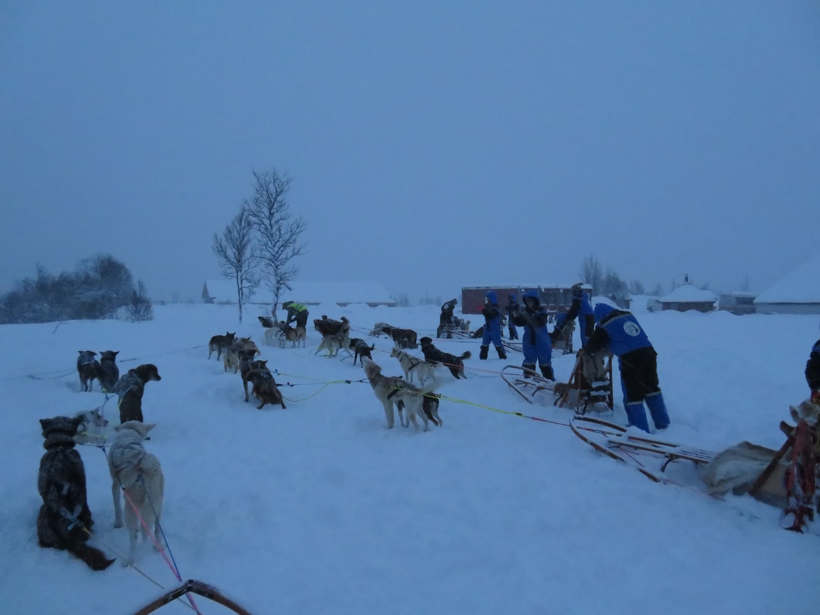
Today, we head out in new snow for a day of dog sledding. We ride a bus from Tromso for 40 minutes in snowy conditions to a dog sledding operation. Here we don huge winter suits, mitts and a headlamp. 


Next we are given instructions on how to drive the dogsled. Each sled is pulled by a team of 6. The front two are the leaders, the middle two are the weakest of the team and back two are the strongest. The dogs can't wait to go. They are jumping and barking as soon as they see us. 

The sled is designed for one person to sit and one person to drive. The driver stands on the runners behind the sled. This allows the driver to jump off and push when they dogs need help up a hill. There are 3 brakes. The first is a pad about 16 inches by 12. It has some ridges on the bottom so it can be used to slow the sled down by stepping onto it. Sleds need to be slowed going downhill and at other times if you are about to overtake another sled. The second brake is for stopping. It is and aluminum sheet with jagged cuts on the bottom. When you stand on this, the dogs will stop. Step off it, and they will go. The third brake is the parking brake. It is an anchor which has to be sunk deep in packed snow to keep the dogs from taking off. The driver should not let go of the sled until the parking anchor is secure. 


The dogs are ready and we are about to start. The first couple sled take off at a high rate of speed. The guy two sleds in front of me, failed to listen to the instruction and stood on the brake for the whole trip. My team wanted to go but I had to continually brake to not overtake the sled in front of me. About half way through the 7 mile course, we stopped to let that slow sled get way ahead. 


The dogs love to run. On the uphill, they stop if you don't get off to help them. On the downhill, they run as fast as possible to avoid the sled from running into them.


We stopped to wait for about 15 minutes to make sure everyone was ok. The dogs didn't like that. They wanted to run.


Finally, toward the end of the ride, the sky cleared and it stopped snowing. What fun this was.


Dec 1 Reindeer


The Sami people of Northern Scandinavia were the first people to settle this area. Recent DNA tests show they came from the Basque area between France and Spain. They own all the reindeer in Norway, Sweden and Finland except for a few which are still wild. They have domesticated these animals and raise them for meat. 

Here our guide tries to settle the lead reindeer down. The reindeer are anxious to get going because they know they will be fed lichen at the end. It was 2 persons to a sled pulled by one reindeer.  


The sleds look crude but they got the job done.


This guy was pulling the sled behind ours' so we got to see him up close and personal for much of the time.


After a short 30 minute ride, the reindeer get to enjoy a treat - lichen.


And when it was all over, we were treated to a stew. You guessed it, reindeer.

Our young guide, Ken, gave a short lecture on the Sami culture. He described the clothes they wore including the reindeer hide shoes. They use dried grass for insulation in the shoes. They have a curled tip, just like Santa's elves. 

Ken also described the proposal trip, when a Sami guy wants to marry a Sami girl. After courting for some time and deciding she is the one, the guy asks his best friend to go to the girls home and ask her parents if he can marry their daughter. Whether they say yes or no, a proposal trip is planned. The young Sami guy gathers all his friends and many relatives and hitches up the reindeer. They sled over to the girl's home, circle the house 3 times before the best friend goes in again to ask the girl this time. If she says yes, she will come out and join her guy and he will hand her the reins to show what is his is hers now. What is hers is probably still hers.

Nov 26 Birkhead Offtrail


Joe, Don and I began this offtrail adventure by walking across Tot Hill golf course on a private right of way. The course was heavily frosted white this morning. There was no one else about as we walked through the stunningly beautiful course. Abruptly, the pavement ended and we were in the woods. Another 15 minutes put us at a point which looked like a good spot to head off trail. Within a few minutes we had located an old road and followed it down. We entered an area that I thought had been a loading deck for a timber cut. There was a pile of stackable rocks and different vegetation in the area. A couple old signs caught me eye. Checking them out, they turn out to be old Joe Moffitt signs in sheet brass nailed to a dead tree.

BE PREPAIRED

NORTH OF CAMP IS A

SPRING THE SCOUTS

THAT REDISCOVERED AND CLEANED OUT

THIS SPRING WERE:

JOEY MOFFITT

WALTER JONES JR

J SCOTT CAGLE

TERRY DAVIDSON

EDDIE ROBBINS

SONNY HAYES

RANDY MANESS

SCOTT HOWARD

TONY HOLT

SCOUT LEADERS WERE

? OBRIEN

SM JOE MOFFITT

ASSISTANT DALE HOWARD

SCOUT TROOP 570

SPONSORED BY LEGON POST ? ASHEBORO

DO A GOOD TURN DAILY


The other sign read:

UWHARRIE TRAIL (in large black letters)

CAMP  (blank)   NO (blank)

BUILT BY SCOUT TROOP NO (blank)

LAYOUT OF CAMP BY JOSEPH MOFFITT JR

STAR SCOUTER (blank) AGE (blank) YEARS (blank) NOV (blank)

IN COOPERATION WITH UWHARRIE NATIONAL FOREST

RANGER BOB CAREY AND LEGON POST NO (blank)

THIS CAMP IS LOCATED ON THE OLD TADLOCK

HOMESTED MR AND MRS TADLOCK ARE BURIED ABOUT

ONE HUNDRED YARDS WEST


Looking nearby, we located the spring house for the home and the family cemetery. I had been here once before from a different direction. The headstone is for both Father and Mother Tadlock. There are two foot stones with initials. The property the cemetery is on is listed as Lillie Voncannon on GIS. I spotted two NFS benchmarks which indicated the property was about 20 by 20. It also appears a cedar post was cut to hold a sign nearby. We scraped around in the leaves thinking we might locate another metal sign, but did not find any.


Is being prepaired like an arranged marriage?


We then walked by an inholding with a lovely field. There were a couple monstrous deer stands here as well. From here we made our way along an old road and ended up at Camp 1 or 1B depending on what reference you are using.


The old sign for this camp has been partially swallowed by this tree. It is a very nice spot but doesn't receive much traffic.


Nearby is the spring, complete with crayfish scurrying about. There was a screen we pulled back to expose the spring. A very short distance from here is the Birkhead Mountain Trail. We made our way to it and followed an old road toward toward Camp 3. When the old road led into the actual trail, we were at another homesite. We poked around here for about 15 minutes looking for a spring. I had thought I had found it on an earlier outing but now I'm not so certain.

From here, we headed up the ridge which would take us back along Talbot Creek. This ridge is loaded with prehistoric quarry debris. We found numerous worked pieces. We found a nice arrowhead with the point chipped off. Don commented that the Native American words for "oh crap" probably were spoken often here. 


After a pleasant ridgeline walk, we located the old mine described as a quartz mine. There was plenty of quartz here but I suspect this was a gold search, not quartz. A number of whitewall tires from the 50s have made there way out here.


Joe spotted this fellow clinging to a tree. I don't see bats during the day very often.

From here, we headed down to Talbot Creek and walked along the social trail back to the Birkhead Mountain Trail and the trailhead.

Nov 29 Northern Lights


Chasing the Northern Lights is one of the big tourist attractions on Tromso. We spent 6 days in the city, hoping we'd have the opportunity to see the lights a few nights. As it turned out, this was the only night the skies were not overcast. So luck was with us. We booked a tour with a minibus so there were about 12 of us and our guide, Mange. Mange was quite knowledgeable but a bit on the gruff side. He drove us out of the city across a bridge to another island. Along the shore of this island, we stopped at a pulloff and got our first glance at the Northern Lights.


From there we drove through a tunnel to another island where we spend the rest of the evening. 


The photos here are all time lapse of about 6 to 8 seconds. By doing that, a lot more light is collected. The night sky was pitch black but that little bit of astronomical light present, was collected in the photos. To take photos of us with the Northern Lights behind, we stood still for the full time lapse and Mange, very briefly, shined his flashlight on us.


Almost directly overhead was Polaris. Not the normal place I look for it. 


Nov 29 Tromso Norway


Our first day in town and we decided to take the cable car up for a grand view of the city. The Fjellheisen is located across the inlet from the main area of Tromso. A trip across the Tromso Bridge by bus was our route. The bridge was opened in 1960 and at 3399 feet, was the longest bridge in Northern Europe at the time.

Note the polar bear and seal on the gondola car. That is the symbol of the shipping company which build the Fjellheisen in 1961.


It takes only 4 minutes for the ride up. At the top, you are 1381 feet above sea level. I would guess the base of the Fjellheisen was between 100 and 200 feet above the sea.


Fjords in the distance. Lots of snow and ice but no sun. The sun was last seen in Tromso on Nov 26 at noon. It wouldn't make another appearance until Jan 13. Today, we have civil twilight from 8:43am-2:20pm but we found that if you wished to do things in light, 10:30-1:30 was the time to get it done. Car headlights are on all the time and street lights are on all the time.


Tromso is on the other side of the inlet. Along the shore, roughly mid photo is where the Clarion Edge Hotel is located; our home for 6 days.


At 2pm in the afternoon, the Artic Cathedral, or Ishavskatedralen.is lit up. It was built in 1965 and is right at the Tromso Bridge.

Tuesday, November 14, 2017

Oct 27 Falls Lake Paddle


This is Falls Lake on the Yadkin River, not the State Park northeast of Raleigh. I joined the Land Trust for Central North Carolina for this paddle beginning outside the small town of Badin. A boat launch ramp allows boats to enter the lake not far from town. However, due to its small size, this lake does not see much motorized boat traffic. 


Our group of nine slides the kayaks into the water and begins the paddle into the main body of the lake. Once leaving the cove into the main body, we can see the Falls Dam not far away. Below this dam is the much larger Lake Tillery. Morrow Mountain State Park also is beyond the dam. Its property boundary currently ends at the dam but will, some day, include lands to the west of Falls Lake including 2 miles of shoreline. The LTCNC is raising money to purchase this property from Alcoa and then transfer it to the State as part of Morrow Mountain SP. That land also includes the Hardaway Site, where Native Americans made stone tools, dating back 10,000 years. 


We briefly stopped at a dry waterfall. The only sizable waterfall in the Uwharries, at 12 feet. I have seen photos of it but today, it looks like any other dry rock cliff. Proceeding toward Badin Dam, it is soon in sight. An impressive looking place. It is situated in a section of the Yadkin River called the Narrows. The topography allows for a dam to be built here with rising land on both sides of the river. When Alcoa built the dam in 1917 it was the largest concrete dam in the world. During its construction, the river was diverted through two tunnels dug in solid rock. Conditions were just right today for us to slip the kayaks through a tight rock maze to the tunnel exits. 


We could paddle into the tunnels about 100 yards before they turned left slightly and became dark. From this point we needed headlamps. Our voices echoed off the walls in an inaudible cacophony of noise. We could hear falling water and were able to make out where it was coming from but our lights didn't illuminate the passage enough to make out just what we were looking at. 


Exiting from one of the tunnels, above, you can see a rockfall has partially blocked the entrance. 

Disappearing into the tunnel

Its dark in here.


You can see the size of these tunnels. They are fairly large and needed to be large enough to divert the entire river during construction of the dam.


After our tunnel adventure, we pulled the boats out along the shore and started a small fire while Mikey read Uwharrie ghost stories.


Our paddle ended well after the sun had set and the sky darkened. We were fortunate to have a nearly full moon tonight. Note the light tube on the front of the boat. We all had green tubes in front, blue tubes in the rear and red ones on our vests in case we went swimming. 

Apr 20 Waterwall on Walker Creek

  Waterwalls redirect floodwater back into the creekbed. There is one very near the Uwharrie Trail on the Walker Creek section. This one is ...