Wednesday, October 28, 2020

Oct 27 Cedarock Park Hike


Just 45 minutes away, it was my first visit to Cedarock Park. Alamance County acquired the property in 1972. It has a long early American history. Beginning in 1820, brothers Clint and Chris Curtis built what is now the Curtis House. A few years later, they constructed a 12 foot high stone dam on Rock Creek which powered a cotton mill. In 1830, John and Polly Garrett built a small one room cabin to live in while they took 5 years building a larger home. The Garrett family continued to live and own the property until 1930. The Garrett home and farm is now the centerpiece of the Cedarock Historic District. One of the more interesting stories of this place occurred during reconstruction. "Old Man Johnny" maintained KKK robes in the attic. KKK members would ride up on horses to "meet" at the farm. Old Man Johnny would make his way to the attic and pass the robes out using a pole. 

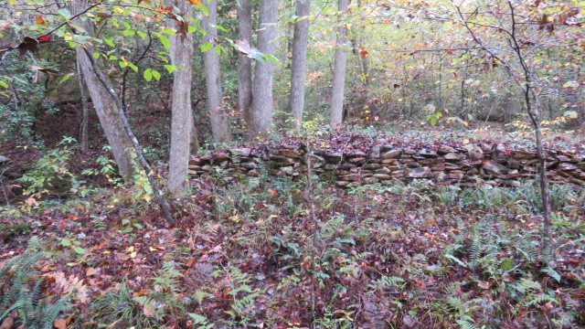
Paul Stevens used German POWs quartered in Burlington to build stone walls.

The Curtis' cotton mill became a grist mill around 1850 when it was purchased by Huffman. It operated until 1880 and was removed in 1930. Things changed in a big way in 1930. A wealthy New York industrialist began purchasing the nearby farms, putting together a 414 acre estate. Paul Stevens came here from NY to help his wife's uncle with his cotton mill. Stevens eventually owned his own cotton mill in Burlington, Stevens Cotton Mill.  He built a home atop a knoll near the old dam. He moved a smaller house onto the property - the Spoon house, to used as an office. He also acquired the Garrett farm. Stevens developed the property as a good gentleman farmer would, maintaining a stable of horses, tending some cattle and creating a system of bridle trails. 

During my visit, I noted the impounded Rock Creek formed a horseshoe around his hilltop home. On the banks were a line of Cypress Trees as well as other ornamental bushes. 


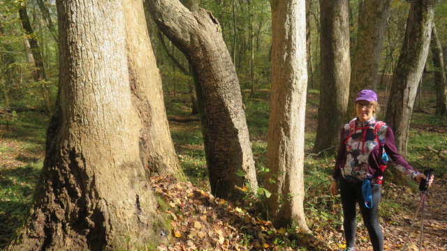
Not knowing what to expect out on the hiking trails, I was initially impressed by the size of some trees. Huge Oaks and Poplars make up the backbone of the forest. Sycamores dominate many of the open areas and, of course, the Cypress was totally unexpected. And then there were the Eastern Red Cedars. It didn't get called Cedarock for no reason. I understand a local resident suggested the name due to the number of cedars and rocks. 

Cypress

The park refers to this as a waterfall!

There are between 5 and 6 miles of hiking trails. The system is based on 3 loop trails designed in a way, that you can hike a big 5+ mile loop utilizing the 3 component loops. A separate system of bridle trails also shares the forest but you rarely encounter the equestrian trails while hiking. 


I left impressed and plan to revisit this place soon.


Our lunch spot

An interspecies marriage


Oct 26 Walker Creek Loop (offtrail)


Check out this burl

I walked a 6.4 mile loop beginning at Luther Place, wishing to visit some places I haven't seen since my days of roaming around searching for a trail rote through here. I tried to follow the original route we laid out. It is barely visible in spots. A large number of mature oaks have uprooted on the hillside headed down to the waterwall. 

Chimney off Walker Creek

Following the drainage that passes near the evaporator (or sorghum cooker), I crossed the Forest Service Road and headed up Black Mountain. Once I encountered the fence and private property, I roughly followed the National Forest boundary until close to the top of Black Mountain. The 3 story observation deck built by a previous owner, has fallen over. You can see it in the photo of the large burl.

Guess what kind of tree this is

Elevated outhouse

My next goal was to pass by the old chimney near the creek. The old Road leading to it has become quite overgrown. It appears someone has been walking it recently. After fording the creek, my route skirts the National Forest boundary again. After getting turned around, I saw a vehicle parked in the forest. I could not imagine how one would drive out here. Then realized I was looking at a junk vehicle on the Eagle Field inholding. I had seen the vehicle there on gis dating back years.

Waterwall

Once I got my bearings, it was a straight shot back to Luther Place.

A Mystery to me

Sunday, October 25, 2020

Oct 17 Jack O'Lantern Mushrooms in Birkhead Wilderness


The bioluminescent bad boys (they are poisonous) of the fungi world. This is the largest grouping of Jack O'Lanterns I've seen. This is the time of year to spot them. And these really grabbed my attention from a good distance off the trail. These are located on the Birkhead Mountain Trail about a mile south of Camp 5. 


Oct 12 Cane Creek Mountains Natural Area


Longleaf Pine

Cane Creek Mountains Natural Area is the latest addition (an "epic" one) to Alamance County's park system. There are 2.5 miles of hiking, including access to the highest point (987 feet) in the county. 

Ghost Pipes


An anomaly of the plant and fungus world, Indian or Ghost Pipes can be seen this time of year. Sometimes mistaken as a fungus, this flowering plant contains no chlorophyll and is parasitic to mycorrhizal fungi which feeds off the rootlets of trees. 


Starting out, you are in a regenerating forest which has had a recent timber cut. this area has some Longleaf Pine seedlings. Plenty of fire ant hills to avoid here. This gives way to an older growth forest with some sizeable trees. 

The trail winds its way up the mountain, getting rockier and rockier. Wear a good pair of boots. 

After reaching the non descript summit, the way down is meandering. Two small creeks flow together and form a nice creek. A wooden bridge spans the creek. 


The trail layout offers a shorter loop of about a mile. Signs direct hikers to hike in one direction. That works well in pandemic times. 

Jack O'Lantern

Ramaria Coral Fungus


Oct 9 Boogie-Woogie on Walker Creek


Boogie Woogie Aphids are also known as Beech Blight Aphids. The Beech Blight name is due to their preference for attacking Beech trees and stripping branches of leaves. Although, they usually cause only minor damage to a tree. They get the Boogie Woogie name because as a defensive measure, they raise their rear ends and wiggle them. Feeding on the sap, they deposit waste on the ground below the branch. These spots grow a fungus called sooty mold. Often these dark spots under the tree are the key to look up. The aphids will be occupying a branch above. Sometimes low and sometimes high.  


Hiking the Walker Creek area is always fun and one of the most scenic spots in the Uwharries. 

Tuesday, October 6, 2020

Sep 24 Channels of West Virginia


Beartown State Park reminds me so much of the Great Channels of Virginia, I used it in the title here. Beartown was just a short distance from the house we stayed in while riding the Greenbrier River Trail. 

I've been here before several times but always welcome a repeat visit. The walkways through the rocks are only a half mile and the park itself is only 110 acres. It packs a lot into those acres and 1/2 mile. The construction of the stairs, bridges and walkways are a bit of an engineering feat too. 

This appears to be a natural basin nestled into the rock

Part of the channels


A local family sold the property in 1970 to the Nature Conservancy just prior to it becoming a state park. Locals claimed bears would winter in the many caves found here. The rock complex resembled a town with the channels forming a road system.


Made of Pottsville Sandstone (locally referred to as Droop Mountain Sandstone), the rocks are pocked with these natural erosions forming unusual and eerie looks. 


Lots of mosses and Rock Cap ferns


Sep 23 Highland Scenic Highway


Purple Asters mixed with Black Eyed Susans and various sunflowers cover the roadside of this attractive highway. We stopped at every pulloff to check out the views and vegetation. 

The forest was cut 100 years ago and has been slow to recover. Clearcutting often results in erosion of the rich topsoil. that is apparent here. As you walk in the forest, many rocks are exposed which probably were not in the heyday of the forest.


Apr 20 Waterwall on Walker Creek

  Waterwalls redirect floodwater back into the creekbed. There is one very near the Uwharrie Trail on the Walker Creek section. This one is ...