Sunday, April 28, 2013

April 26 Sugarland Mountain Trail


Sugarland Mountain Trail follows a ridge from the Appalachian Trail to Fighting Creek Gap (more often referred to as the "parking area for Laurel Falls"). The small group of 12 meets at the parking area and are driven to the top in a UT van piloted by Spring Wildflower Pilgrimage coordinator Ken McFarland. It is a tight squeeze in the back. The windows fog and I really can't see much on the drive but do get to converse with a couple seatmates. 

When we stop and pile out, I'm expecting freezing temperatures but instead remove my outermost layer. Our  leader is the multi-faceted Doris Gove, a trained entomologist, hiking guide author, botanist, salamander seeker and fellow former New Englander. I've hiked with her several times before and anticipate a lively hike sprinkled with her folksy trailside commentary and wry sense of humor. As we make pre-hike introductions, "Tree Guy" informs us he will be taking rudimentary tree measurements as we go. He intends to loosely follow us as he conducts his survey. He explains his interest in this particular trail as it once was the boundary between the timber properties of Champion and Little River. Little River cleared up to the ridge but Champion did not. He is interested in what trees are there and how large they are. A map of old growth forest is available at Sugarlands Visitors center. Later, several of us will run into each other purchasing that map. Our trained Botanist today is Chris Fleming, a handsome young environmental consultant from Nashville. Two days later he will be married at the Missionary Baptist Church in Cades Cove. He explains it requires a $50 permit - what a bargain. Their reception is at the fine dining establishment in Townsend, the Dancing Bear and a delayed honeymoon - Memphis in May is planned. He has a great personality and explains flowers quite knowledgeably and in an easy to understand fashion. Our sweep is Allen Sweetzer. I've met and hiked with Allen before. He is part owner of a cabin near Scott Mountain, right at the end of the manway leading up and out of White Oak Sinks. He is the resident expert on the Sinks. I comment to him about our mutual acquaintance, Margie Hunter and her AT trek.  I have followed her excellent blog Smokies Blog. Allen confirms, she is not enjoying her AT hike. I hope that changes.


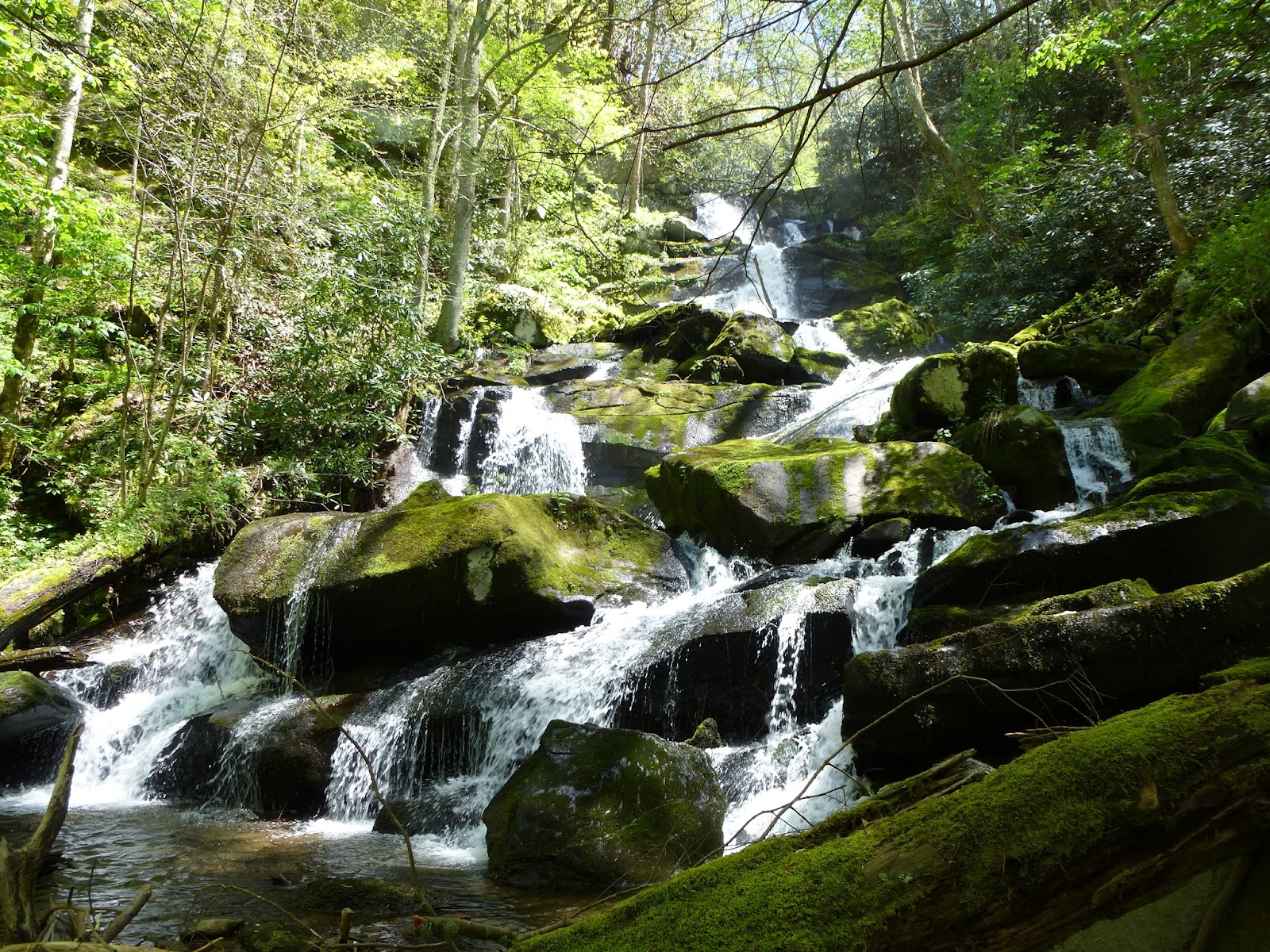
Our hike today is described as a hike through Spring. Beginning high in elevation, we begin to see the earliest signs of Spring, Trailing Arbutus, then Spring Beauties and Trout Lilys. Further we run into the second wave of Spring wildflowers, Trilliums, Bellworts, chickweed, violets and the rest of the usual suspects.


We make an early stop at Mt Collins shelter. No one is there. Doris informs us, her hiking club, Smoky Mountain Hiking Club has completed renovation of all shelters in the park. This shelter was renovated a couple years ago. Previous shelters were typical Adirondack style, three sided shelters with a wire mesh across the front. Hiker interactions with bears was commonplace. A club member architect redesigned the shelters to encourage food consumption at a covered table away from the sleeping area. This design has reduced the number of bear encounters. However, it has not eliminated them and when encounters are reported, sometimes campsites and shelters may be closed until bears have moved on elsewhere. A moldering privy accompanies the shelter. Above ground decomposition of waste is more effective than a below ground pit privy. The drawback is, hikers are asked not to pee in the privy as this retards the decomposition process. 

The photo above is of a tree growing from another tree. This growth is occurring about 40 feet up which is quite unusual. 


A mountain wren sings to us. It is such a pretty song, so much nicer than the emphatic Carolina wrens in my yard. We also hear Black and White, Black Throated Green and Hooded Warblers. A blue backed, white fronted bird is spotted but we have no bird experts along so we guess wildly at what we are watching. Later a fledgling Hooded Warbler alternately flits ahead of us for about a hundred yards. I got one good look at this handsome yellow fellow.


Chris did a great job explaining the differences in Chickweed. Above we have a Tennessee Chickweed flower. Below we have a Bellwort. We also say many Sesile Bellworts, also called Wild Oats. Finally, my last photo is of Wood Betony or as Pilgrim Cindy pointed out, "Lousewort". Despite the unpleasant name, she thought there was a kinder meaning of the term. I have learned the name is derived from the word "wort" meaning plant and the belief the plant either caused or cured lice. Today we know the plant hasn't anything to do with lice and so, perhaps it does deserve a nicer name.


We travel through several very rich seeps with an abundance of plant diversity. These areas are of special interest to Chris. He takes many photos as we work our way through. In one such area we see dozens of large Cherry trees. Obviously this area was not timbered as it was perhaps the most valuable tree of any in the forest and these specimens were hundreds of years old.

At our final trail break, Pilgrim Beth pulls out her cache of gourmet foods and passes out some very tasty vegetable chips. At lunch she was very generous with her smoked gouda, crackers and dried peaches. I learned later she is an accomplished adventurer with visits to the Congo, a cross state bicycle ride and other endeavors. Her trail companion, Pilgrim Cindy was a delightful hiking companion on the final leg to Fighting Creek Gap. She is well read and has similar outdoor interests. A June float through Grand Canyon is on her agenda. I also enjoyed hiking with longtime friend, Pilgrim Randy. His hearing prevents much trail conversation but I've enjoyed his companionship on numerous hikes.


This evening my foot told me it had had enough of these hikes so I made plans to skip tomorrows 13 mile jaunt between Elkmont and Tremont. My foot was so happy I made that call.

April 25 Mill Creek Falls


Mill Creek Falls, reputed to be the highest waterfall/cascade in the park, is not accessible via trail. It is a 4+ mile scramble up Mill Creek. Mill Creek is the creek with flows by the Cades Cove visitors center and powers Cable Mill. Our leader today is veteran historian and off trail scrambler Ken Wise. I've hiked several times before with Ken and know his laissez-faire style of leading hikes. We have a group of 25 which I regard as high number for an off trail hike.

We meet at the Cades Cove Visitors Center and get a relatively late start. After a short walk along the road, we disappear into woods between two walnut trees. There is a dug road here but it has many fallen trees on it. We go from one road to another and finally end up at Mill Creek where Ken utilizes a fallen tree (above photo) to cross the creek. We slip and slide at another spot creekside and finally head up on the hillside to get away from the creek and its steep bank. From here it is fairly easy going until the creek bends at a choke point and we have to negotiate a narrow bear and deer trail on the steep slope. After a laborious descend we are at Sugar Cove another choke point. I mention the choke points because I know they are key landmarks and we have to travel through them on the return. The group huddles for short break and then proceeds. The going through the cove is difficult but only because of numerous downed trees. It is relatively flat. 


It is in this area we encounter the giant Chestnut Oaks above and below. This specimen is quite impressive.

Some of the lead group I'm in hears shouts behind and we turn back only to be told to go ahead and cross the creek as best we can. We find a rotted log and make the crossing. It looked much worse than it was. Now we're in Rhododendron and there is only as slight trail through it. We regroup and some take out sandwiches as it is well past noon at this point. Finally Ken arrives and counts us. Then counts again. Uh oh, there are only 23 of us. Quickly we determine two women are missing. Their husbands are with the group but they don't appear to be panicky.  Ken whistles loudly, then shouts, heads back a short distance and repeats the process. The creek is providing enough background noise we can't hear much anyway. He returns and announces we have only one option, continue on to the falls, eat and find the missing folks on the return. I'm stunned. No one objects so I offer to head back, find the gals and go to the Sugar Cove choke point and wait. Ken reconsiders, says he will find them and I should lead the group on to the falls and back. We have another leader but he has no clue where we are and really should not be expected to lead in this terrain. I'm confident I can negotiate this but whisper to another pilgrim "I don't like this". She nods back and we start off in silence. Ken has instructed us to go high through this area and a couple folks head almost straight up. I try to stay in contact with them, instructing them to go lower and left but after 15 minutes I can no longer see them. We manage a rough route through this terrain. I stepped in a fresh pile of bear scat at one point. We finally arrive at the base of the falls and I try to count heads when I see Ken coming along with the two lost souls. Still I'm concerned about the two or three folks that headed up high. Then I see someone waving way up next to the falls. No one else wants to hike anymore at this point so I make my way up over the boulders and there is Todd, Mary and Greg enjoying lunch. I join them for an up close lunch by the cascade. 


The cascade is truly a big show for such a small creek. At the very top of the visible cascade the water is forced to one side. I would love to climb and see what this looks like from above. Perhaps the cascade continues higher and we just can't see the upper portion. Today I don't have the energy nor the time to make the short steep climb. According to the Tennessee Landforms website, there is an arch rock up there too. Does someone want to join me for that adventure???


The walk back was pleasant but everyone, including me, was operating on reserve energy. "Impulse power" as Captain Kirk would have put it. We did have one period of anticipation. After crossing the creek a final time, our advance group of 16 waited 20 minutes for the final group to join us. We were told someone was having trouble breathing although everyone appeared to be fine. I offered some water to one gal who gulped it down. It was the second hike of her life. She wore tight jeans, cotton shirt and didn't bring a sufficient water supply.

Our final regrouping spot is along a dug road in a bog. There is a chimney here that I walk by, perhaps 30 feet away, and don't even see it. Here we must head right up the hill to find another road which is mercifully close. We stride out into a meadow just yards beyond the twin walnuts and manage the short stroll back to the visitors center. I don't have much left in the tank but am in better shape than many as they trudge back to the cars.

April 24 Mushroom Walk


Our first Spring Wildflower program this year is led by UT student Christine Braaten. In the group photo, she is 5th from the left. The program was titled "Edible Mushrooms" but she covered anything we saw and described some of the nastier mushrooms one might find later in the year. Mushrooms are not plentiful in the spring. We saw a couple morels, some polypores and not much else. Later in the summer, you should see mushrooms everywhere, particularly during wet periods. 


We're in the Greenbrier area of the park, at Injun Creek Trail. I can't help but photograph some flowers while on this hike. The 3 wildflower scenes shown here are all in an area about the size of a front yard. Between the road and the river is a rich area. I walked here and couldn't resist. 


Foam flowers were the dominate flower today. Some places they seemed to go on forever.


Christine had brought some morels to show us although we did find two almost immediately after starting our stroll. Morels pop up in the spring for only a 2 or 3 week window. Foraging in the national park is permitted for up to one pound of mushrooms. She prefers to pick young ones before the exterior starts to turn light brown and small pieces crumble off when handled. I'm happy to find them in any state and can't imagine what it would be like to find enough to be choosy. Next she found some Devil's Urn a small dark brown urn shaped fungus which grows on fallen wood in leaf litter. It is hard to spot.

Next we locate some Turkey Tail and False Turkey Tail. Both are polypores and look like fanned out turkey tails with multi colored zones. The underside of the False is smooth and the Turkey Tail underside is not.

Christine has reminded me not to forget the those "Ganoderma beetles" feeding on the Reishi. They are Megalodacne fasciata, the Red Banded Fungus Beetle. 

We also found some coral fungus, dried witch's butter and shelf fungus.


Tuesday, April 23, 2013

April 18-21 Coastal Bicycling


My first road ride is a relatively easy 4 day ride in coastal North Carolina organized by Will Truslow. Here is Will  making a u-turn on the scenic route from Beaufort to Cedar Island. He has organized similar trips many times before.

Our itinerary is to congregate Wednesday evening in the coastal town of Beaufort. On the waterfront we stay and stroll and dine. The Shackelford Banks are visible. We scan them wild horses but see none. Rachel Carson, author of Silent Spring has a preserve named in her honor here. She apparently conducted research here and was instrumental in preserving it.

One member has a punctured tire we discover this evening. A local bicycle shop is nearby and the owner operates the shop out of his home so we are able to make the necessary repairs in the hotel room.

I spend a restless night, anxious to get started. We are off close to first light in the morning. We have to ride the 40 miles to the Cedar Island ferry for a 10am departure to Ocracoke. A quick stop at McDonalds provides some coffee and calories for the ride. It is a gorgeous morning. There is no wind, no clouds and temperatures are just right.

There are a few convenience stores along the route and some very small communities but nothing else in the way of development. A couple bridges provide wide expansive views with lots of water and wetlands. At one bridge we watch stingrays in the water below. I don't know the proper term for a group of stingrays. I just looked it up. We watched a "fever" of stingrays.

We arrived at the ferry terminal with plenty of time to spare. Cars are $15 and bicycles with rider are $3. We load last and disembark last. The ride is over 2 hours crossing Pamlico Sound. Dolphins are spotted a couple times gracefully arching out of the water and slipping back in. A group of three brown pelicans skims the water and effortlessly pass the boat now cruising at top speed. Laughing gulls keep us entertained. Tom shares some crackers with some, trying to entice one to feed from his hand. The gulls are so agile they can snag a cracker scrap in midair. 


To arrive in Ocracoke, we have to make a wide right, then left and right back into the slip. You can see the shallow water causing these maneuvers. As the waves created by the boat cross the shallow water, they break in a long continuous white capped wave along side the ferry.

Rooms are ready at the Harborside Motel. Most of us enjoy trout sandwiches or fish and chips for lunch on the waterside deck. Bicycling around the town, we visit the iconic lighthouse. It is the oldest operating lighthouse in the US, having been built in 1823. It is a beautiful white color. Walls at the base are 5 feet thick. It looks solid. We also stroll out to Springers Point, a maritime forest protected by an easement with Coastal Land Trust. Live oaks, eastern red cedar and various holly and bays make up the majority of the trees here. There is one grave, a fellow buried with his horse. On the narrow beach we are at the "point" separating Pamilico Sound and a broad inlet known as "Teach's Hole". Notorious privateer, Blackbeard (Edward Teach) sheltered his ships here until that fateful day in 1718 when he was killed by the Royal Navy. His headless body was tossed overboard where his body swam around the ship 7 times (other accounts place the laps at 5 - much more believable). His head was stuck on the bowsprit and paraded into harbor. His skull was later used as a punchbowl!

Continuing our tour of town, we visit a few local craft shops. Will purchasing a bamboo shirt at the Hemp Shop. The shop owner tells us bamboo is the greatest material for shirts. It doesn't absorb odor, wicks, feels great etc etc. Below you can observe the various high water marks on a nearby shop. Major hurricanes have hit Ocracoke in 1899, 1933 and 1944 according to historical marker. No one has ever perished in a storm. Another storm in 1846 created Oregon Inlet and Hatteras Inlet, the inlet separating Ocracoke from Hatteras Island.

It is birthday day. Daughter Amanda is 32, Pete in our group is 55 and Will is 60 but somehow still thinks he is in his 59th year. New math I guess. Howard's Pub is our evening destination. A pitcher of Two Hearted Ale and a bluefish dinner make it memorable. Somehow, Will's wife has arranged to pick up the tab and get a slice of birthday cake for the birthday boys.


Friday, we have a leisurely morning on the island and then are to ferry over to Swanquarter. Someone has alerted us of a Greated Horned Owlet in a tree by the ferry. We spend some time looking at the strange bird perched in a cedar keeping vigil.

The ferry ride over is relatively uneventful. A passing shower get everything wet. Once we land, we start riding with nice tailwind for half the ride into Belhaven. My foot is bothering me this afternoon so I opt for the sag vehicle the final leg into town. Will has secured a house for the evening. Built in 1906 the home provides everything we need. We manage taking creative showers in a old clawfoot tub with just a spray hose. No curtain or hose holder. The evening meal is at a local diner, Georgie's Sports Bar and Seafood Restaurant. Several of us like the crab cake description and lured into ordering it. Easily it was the most disappointing meal of the trip. Gary has dolphin and says it is the best meal he has had. Rain comes during the night, pelting the tin roof at a decibel level I can't sleep through.


After a quick breakfast at O'Neals we're back on the road racing to another ferry. We make the 9:15 Bayview to Aurora ferry. Above, we are warming up in the ferry terminal. The night storm brought a cold front in, knocking temperatures into the 50's.

Right off the ferry, we pass a huge mining operation. Phosphate rock is mined here. the open pit mine goes on for miles. A couple miles from Aurora I have a flat and ride the sag vehicle to town. After having a founder sandwich at Lyle & Shirley's Restaurant, I change the tube and am ready to head out again. I ride the first leg of the afternoon and drive the final leg into Oriental. We stay on the waterfront in Oriental at the Oriental Marina and Inn. Our three bedroom suite is right above the Tiki Lounge. Several of us, tour the town on bicycles. After, we retire to the Tiki Lounge and have several rounds. On our pre-dinner stroll we run into local Chrissy Fulcher Cahoon and learn all about crabbing, crab processing and marketing. She is involved with a mini crab processing empire and seems well versed in many aspects of it. I have a great crab cake tonight.


Here we are, stopping on Sunday morning at "Bama's" cafe for breakfast. This stop fuels us for the final ride back to Beaufort. We have wind in excess of 20 mph at our back on the ride to the Minnesott  ferry. After getting off, the wind is coming diagonally into us. The final 10 miles are difficult. Crossing a high bridge, the wind blows all of us so hard there is concern we will get blown off the bridge. Tom takes a spill and his bicycle is damaged slightly forcing him to call it quits a bit early. We manage the final leg to town and cluster back at Inlet Inn where we began 4 days earlier. 


April 13 Uwharrie Morels


Our spring has been late compared with the last 2 years. According to the bloom charts we are two weeks late using historical bloom dates. I found about a dozen today but left several small ones. I don't know if I'll be able to return but left them anyway. One was filled with ants but tasted just fine.


March 2013 Trailcam


Just testing the new Moultrie Trailcam. It is secured to a white oak right next to a well worn deer path, right between 2 deer stands. Nothing but deer this month.

Photos taken during the day are in color but the night shots utilize the infrared light and are black and white. One difference I notice right away compared to my previous camera, the deer don't look into the camera. I think the last one had a more audible click when the infrared light went on.


Saturday, April 13, 2013

April 8 & 9 New River Trail


This bicycle ride covers two days. Beginning on Monday, I have left my overnight gear at a rental cabin outside Galax. They are right on the trail - Chestnut Creek Cabins. Then I start riding in Draper where I will leave my car until I return. It is 12:30 before I start and already close to 80 degrees. I notice right off, there are numerous trees cut up alongside the trail. The trail is in rougher condition that I remember last year at this time. The surface is wet in spots and it feels as if I'm riding with flat tires. Above is the Hiwassee Bridge, the first of 3 river crossings. The trail crosses many side creeks too but the New River crossings are substantial bridges.


Remnants of the railroad are still present. Above is the Chestnut Yard turntable where engines were turned around to go back. This was the end of the spur at one time. It is another 6 miles to Galax, where the rail was extended to.


Bloodroot and Dutchmans Breeches are blooming on the cliff and hillsides. The soil is quite rich in this area and supports many wildflowers but today we are experiencing a bloom two weeks late

By the end of the day I am very tired, having ridden 40+ miles in the heat. It is 5:30 when I finally spot the log cabins trailside. I had planned to ride into Galax for dinner but am too tire for that.


The next morning I am rested and ready early, leaving the cabin before 7am. It is over 18 miles later I see the first person on the trail. Above is another New River crossing.


At Foster Falls you can ride right down to the water's edge as I have done here. I had a relaxing snack here mid morning.


I spoke with a couple state employees along the way. One fellow told me 240 trees fell between Pulaski and Foster Falls. Almost all in one snowstorm. The other ranger told me 900 trees had fallen on the trail as a whole. Crews from 6 states helped clear it. I still saw piles of firewood along the trail.


My ride ended about 12:45 on Tuesday back at my car in Draper. I felt much better at the end of the second day.

Sunday, April 7, 2013

April 5 Most Rugged Section of AT


Earl Shaffer wrote in his book, Walking with Spring, about his 1948 AT through hike, "This couple of miles was probably the most rugged and most spectacular segment of the trail." He was referring to the Pinnacles of Dan in Virginia. The segment of the trail was relocated to the west but in 1948 was part of the AT. It started as a joke. Myron Avery was scouting this section of Virginia for possible trail routes. He had a couple trail scouts working ahead of him. They scouted routes and Avery either approved them or relocated the trail. The trail scouts had a great time climbing the steep pinnacles and decided they'd route the trail over them, knowing that Avery would not approve. Apparently, Avery called their bluff and approved the route.


Here is the view from the tallest pinnacle. The route up here is a scramble. You are constantly looking for handholds and footholds. There is a cave near the top. We stopped in it briefly before the last scramble up. Once on top, I noticed carvings in the rock. We could not make it all out but it appears to have been craved there for a few decades. There was lichen growing in and around it.


Early spring wildflowers were growing in the rich soil. We saw Bloodroot, Dutchmans Breeches, Trailing Arbutus, and a few other usual suspects.


The property is owned by the city of Danville. The Dan River winds through, The city has built 2 dams and pipes the water from the first dam to the second. Below is a section of the pipe, now replaced. 

Danville has operated an hydro-electric generating plant here since 1885. It was the first municipally owned electric plant in the country. When I walked through the plant today to obtain an entry permit, I saw new transformers ready to be installed. So it looks like it will continue operating for a while.


Thursday, April 4, 2013

April 2 Big Creek to Mouse Creek Falls


This was a very easy 4 mile walk on an old railroad bed along Big Creek. The two big attractions beside the creek, are Midnight Pool, seen above and Mouse Creek Falls, seen below. After passing Midnight Pool we saw a couple kayakers paddling down the creek. I wanted desperately to video them as they went over the fall into the pool, but we were too far upcreek to view that.


Mouse Creek enters Big Creek from the opposite as the trail. You get a great view of the falls looking across Big Creek. As you may be able to make out, the upper fall enters a pool before dropping into Big Creek. It is pretty noisy here.


For a lot of the hike, the trail is creekside. Here we are right next to the creek. On our way back we again encountered the kayakers. I tried to set up for another video in a long stretch of tight chutes and technical turns. I waited about 20 minutes before thinking they may have portaged around us. Just within a minute, we saw them pass by but by that time we were back on the trail and did not have a clear view. 


March 31 Early Flowers on Porter's Creek


It was a slow walk on Porter's Creek Trail today. Not as slow as this fellow, but I am nursing a sore foot still. We had hoped to run into a slew of wildflowers but Spring is hesitate to come this year. 


About a mile and a half from the parking area you enter the big wildflower fields just after crossing the creek. Normally, at peak Spring bloom, this spot looks like a snow field, covered in fringed phacelia. Not today. We saw a few but they are holding back this year.


We did see a few spring beauties including this one.


Another spring beauty.

Weekend on the Dan River


It is a good morning at the Rt 704 bridge. Will has made arrangement's with the couple in the house in the upper left corner, to park his car in their yard for a few days. When we go to retrieve his car a couple days later, they are concerned we have not survived the cold weather.

It is only the third time I have paddled my brand new Dagger Axis. It has just enough space to load my camping gear. It is really packed tight. My hands are numb before we even shove off. I thought the new gloves I purchased would provide some warmth but my hands feel better with the gloves off. 


Today was a series of class one rapids and a few rock gardens. We stopped a couple times for lunch and breaks but spent most of the time on the water. It flowed along at a nice clip so we didn't wear ourselves out paddling. 

By mid afternoon we were in the vicinity where Will had planned to camp. He had researched it and found a spot where we would not be within sight of a home. It was rather remote on the river left but a few homes could be spotted on river right once we got out a roamed about. Of course we camped right beside a no trespassing sign. The river's edge was well posted at every conceivable spot to land a boat. We were very careful to leave no trace of our campsite the next morning. 


Since we had a few hours of daylight we decided to explore a bit. After walking downriver a short distance we tackled the cliffs rising up from the river. Eventually we found an old road and followed it about a half mile. Along the way we located an old house, now fallen. There was a well beside the house and later we located another well down the hill a bit. We also came upon the grave of Charles E Moore 1813-1894. It might have been his home. Looking back to the second photo in this entry, you'll see Demon Rock. We sat across the river from this rock for about 20 minutes before heading back to camp.

That night we heard several screech owls working their territory. 


It was another cold morning, probably just above freezing. We are slow to pack up and finally shove off. The terrain today boasted many more rock cliffs alongside the river. They populated both side of the river. 

We paddled by quite a few fish camps and seasonal homes. As we approached Hanging Rock State Park, the cliffs became more dramatic and the houses thinned. We finally saw one fine home perched high above the river on river left, complete with a well engineered deck jutting out from the clifftop.


We paddled through the small section of the state park which is on both sides of the river. Directly after this is the Dan River Company, a river outfitter with a few cabins riverside. We then passed through some pastoral land before arriving at Moratock Park in the town Danbury. There is a landing spot on river left where the park is but we chose a spot directly under the road bridge on river right. Here it was about a 3 minute walk to the Danbury General Store and some hot lunch. As we sat eating, many bicyclists whizzed by.


After lunch we had a short paddle of perhaps 7 miles to go. The river is a bit tamer here with some class one rapids and some shallow spots. We passed under 7 Island Bridge. The bridge is in terrible condition. Although it still serves traffic, some of the pillars have rebar  completely exposed amid crumbing concrete from river level to bridge bed. 


I'm pretty tired by the time we pass Mt Horrible. Don't you love the names of the rock formations? Shortly we pull off on river left and find a suitable spot for another night out.


 This afternoon, Will leads a walk to a rock cliff downriver which has a sizable cave it in. The scene below is just in front of the cave. It is reportedly the former hideout of some Confederate deserters from the area. They hid here for a short while at the end of the war. It looks like you could make a home of it under those circumstances. Great view too.


I have no pictures of our last day on the river. It was sleeting and freezing rain. We just paddled hard for the short way to our takeout at the Hemlock Golf Course. It was Sunday morning but there wasn't a soul on the course.

Apr 20 Waterwall on Walker Creek

  Waterwalls redirect floodwater back into the creekbed. There is one very near the Uwharrie Trail on the Walker Creek section. This one is ...