Monday, September 24, 2012

Sept 20 Cumberland Trail


One of the hikes offered at the SEFTC conference was a 10 mile walk on the Cumberland Trail. It was judt 3 of us going. Tony Hook, a Cumberland Trail Association employee was leading through a section he maintains. The Cumberland Trail which runs from the Chattanooga area to Kentucky is complete in some sections but there are major gaps still. This section followed some old roads but was for the most park, new trail. Given all the sandstone in the area, it is difficult building trails here. Much rock work is needed. There are numerous rock steps throughout this section.


Above is our lunch stop. The water was really flowing due to some recent rains. I am told kayaks run this waterfall. 


Above we have a fossil in the sandstone. Sedimentary rock was formed in layers. Many of these layers can be broken apart and contain fossils. Tony said one of the most common fossils is that of Club Moss, an eighty foot high plant with palm leaves at the top. Just a bit taller than today's Club Moss.


Check out this Hen of the Woods


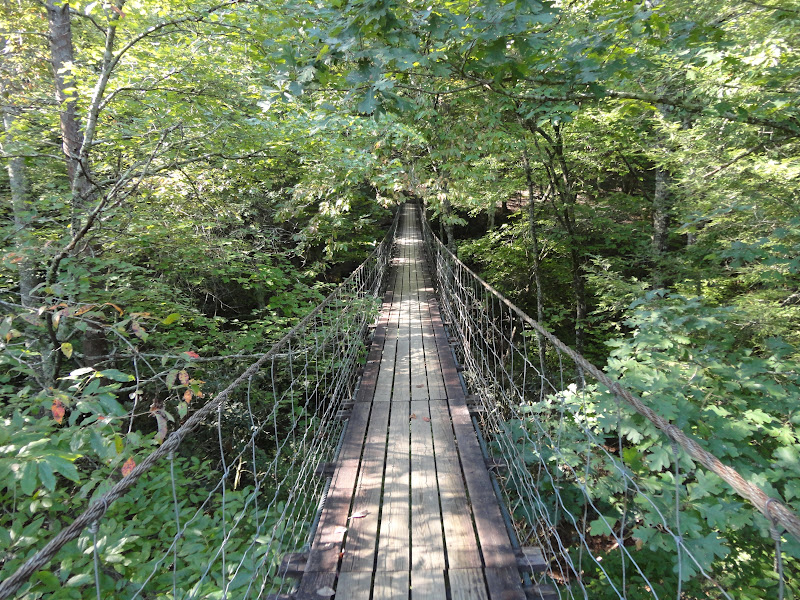
This bridge as well another on the outing are fiberglass with treated wood tread way. They can be bought as kits. The logistics of getting the materials to the site are difficult. Usually the materially can be hauled by some type vehicle close to the site but from there a zip line has to be built the get the material creek side. A scaffold bridge is build and the fiberglass bridge is laid on top. The butts are usually concrete secured by rebar to the rock. 

Sept 19 Fall Creek Falls State Park


Attending the SEFTC (Southeaster Foot Trails Coalition) , I traveled to a state park in central Tennessee I'd never heard of, Fall Creek Falls State Park. As state parks go, this place is top notch. It was once considered as a national park.

The main attraction is Fall Creek Falls, below. The highest free fall waterfall east of the Mississippi River. The sedimentary sandstone layers of the Cumberland Plateau are perfectly suited to construct waterfalls. Sandstone erodes more easily than other rock. Limestone layers erode even easier. This sets up the perfect place for waterfalls and caves. I am told this park has a more extensive cave system than anywhere else in the US except Mammoth Cave National Park. Some of the caves were unknown to the park staff until they were threatened to be flooded by a nearby town's waste water. Suddenly, the local caving community revealed the secrets to have the caves protected. One of these is a spectacular cave with a huge underground room.


Originally, the land was purchased by the Interior Department with the intent to give it to the state of Tennessee. There was an attempt to have it considered for inclusion in the National Park system but the inspecting team visited in summer when the waterfalls were dry or so the story goes.

Now the state park has all types of camping from backcountry to full hookups, There is a lodge on the lake with conference center. There are group lodges both small and large. There is a store, snack bar, restaurant, boat docks, a nature center and at least 3 cable bridges. I understand the cable bridges and falls were used in scenes from the movies Jungle Book and King Kong Lives.


Sept 14 Cooks Wall to Moore's Knob


When you live in the piedmont area of North Carolina, there are not many places you can visit which offer great views, a high spot to catch a breeze or hike in rugged terrain. Hanging Rock, merely an hour from Greensboro offers all that. Today, we hiked a short 10 mile loop incorporating Wolf Rock, House Rock, Cooks Wall and Moores Knob. There are nice views south and west at these spots. 


We encountered a long, four to five foot Black Snake, a Northern Water Snake, and a Black Racer but little other wildlife.


Sept 11 Doughton Primitive Trail


This is my first difficult hike since I virtually quite hiking during the summer. Everyone knows this hike starts out as stroll on an old road following Basin Creek. At the Junction with Grassy Gap Trail there is another trail, Bluff Mountain Ridge Trail. Our hiking club knows this only as Primitive Trail. There is a sign which states it is a primitive trail so that must be the genesis of the name. Also, the latest NPS trail map lists it as the Bluff  Ridge Primitive Trail.


It is just under 3 miles to the picnic shelter. About 2/3 of the way up you reach Brooks Knob at over 3300 ft. At this point you descend into a saddle before the final struggle up to the shelter. The park service has recently painted this shelter covering up most of the graffiti and also making it seem light and airy instead of dark and uninviting.


The motel owned by the Park Service in Doughton Park has been closed for a second season as has the small nearby restaurant. For several years the previous concessionaire received one year extensions. With such short term leases there were no major improvements made by the concessionaire. Problems with a new roof and closure of the BRP in the vicinity caused the concessionaire to not renew and the Park Service has been unsuccessful in attracting some one else. At 24 rooms and saddled with a short season, it is difficult to operate.  


The remainder of our 13 mile hike went through the gorgeous meadows of this area and ended up on the scenic Cedar Ridge trail.

Sept 9 New River bicycling


What a great to bicycle. The temperature was cool and sun was shining. Our group began at Foster Falls and headed to Fries Junction and back. As we drove to the Foster Falls parking area, the large abandoned building near the entrance gate was being remodeled. This building began in 1888 as a hotel. The hotel lasted until 1914. A few years later in 1919 the Abingdon Presbytery bought it and operated an indutrial school for women. In 1938 it housed a co-ed orphanage know as the Abingdon Presbyterian Children's Home. Musch of the original appearance of the building was altered by a fire in 1940. When the orphanage closed in 1962 it lay abandoned until now. 


Sept 2 Mandan Trail


A paved Rail Trail traveling from Easthampton MA, through Northampton and beyond, with a spur over to Rt 5 near the Connecticut River. I entered on the spur. The first few miles travel through some suburban spots and some rural terrain. There were many late summer flowers blooming. At the junction with the main trail, I headed south toward Easthampton, through the Williston campus and beyond to the terminus.

  
 Turn back and cover the same trail back to the spur junction before heading north. This is a relatively quiet ride until you reach the outskirts of Northampton. The trail jumps around here as you cross streets, pass the old railroad station (below). There is an old hotel building directly across the street from the former station. Fortunately, the trail crosses the main street of downtown above on a bridge.

Not far from here you have the option of continuing on the Mandan heading out of town in a northwesterly direction or you can hook up with the Norwottuck Trail. It is a bit tricky to make the connection to the latter. You look for a dirt trail crossing a couple of live railroad tracks then down a grassy hill onto a street and somehow you are now on the trail. It it a short distance from here to the Connecticut River. The trail has its own single track bridge crossing. At this point the trail follows alongside Rt 9 to Amherst. That road has quite a bit of traffic on it, particularly this Sunday. It is a few miles from UMASS campus.


For some reason this trail is also referred to as the Spandex Highway. It was stenciled painted in a couple of spots.


Mar 26 Check Dam on Taylor Creek

  Another dam in the Caraway Creek drainage is one that many people have seen as it is visible from Lassiter Mill Rd. The owners on creek ri...