Monday, September 16, 2019

Sept 12 AT Hike from Front Royal to Massie Gap


A friend is closing out his section hike of the AT. This is one of his missing gaps. Beginning at the trailhead outside Front Royal on Rt 522, we pass by this chain link gate and fence for the first 1/4 mile. Obviously, it is a government facility. A sign says it is the National Zoological Park's breeding facility. That would explain the giraffe and panda. 

While at the trailhead awaiting my friend, the kiosk had a notice from the local community to Trail Angels. It advises them to be mindful of the litter created by the packaged items being distributed. I wonder what happened. I would think Trail Angels would be careful to clean up. 


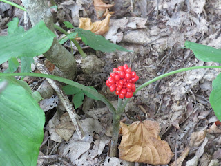
Above are the seeds of Solomon's Plume. The mottled red color is quite nice.

Two big takeaways from today's hike, are the big trees, especially Tulip Poplars and all the Japanese Stiltgrass. The Stiltgrass probably covered the trailsides for 2 miles of this section. I've heard it theorized that the trail is a conduit for it to spread. 

We walked through some overgrown fields to begin. Then up a long hill in mature hardwoods. The walk down the hill was very gradual and pleasant. Then we hit open fields where the trail was just a narrow dirt path. The temperatures started to rise. It would get well into the nineties, making afternoon unbearable. 

Japanese Stiltgrass lines the trail

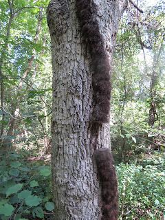
Poison Ivy with a missing link

Mosby, known as the Gray Ghost

The last mile was downhill but over rocky terrain. Just before reaching the trailhead, a poster espousing the virtues of opossums reminds us how beneficial these cuddly guys are. 


Sept 11 Hawksbill - The one in Virginia

Jack in the Pulpit

Highest point (4050 ft) in Shenandoah National Park, Hawksbill sports a 270 degree view looking south, west and north. It is a short hike from the Skyline Drive. The Appalachian Trail passes closely. Balsam Fir is supposed to grow in the area. I didn't see any.

White Wood Aster

Golden Rods


Senator Harry Byrd built this shelter, appropriately called Byrd's Nest. The fireplace has been filled in. The area around the summit is a sensitive area, so camping is not permitted. The shelter probably once served as an overnight shelter. Today is has a bar floor and a picnic table. Any bunks that may have been here, are now gone.


Milkweed

Monday, September 9, 2019

Sept 3 Four Corners


Sept 2 Mesa Verde Cliffdwellers


Here is Cliff Palace, the most famous of the Mesa Verde cliff dwellings. Access is restricted to 50 person tours throughout the day. They last about an hour. It is a short walk down to cliff palace. The exit involves a ladder and narrow sandstone steps. The 150 room, 21 kiva structure housed about 100 persons. It is thought it might have had an administrative function. Most rooms are built without a roof, using a ladder to climb down inside. It was built between 1260 and 1280. By 1300, it was vacant.


Heavily looted in its years after rediscovery in 1888 by some local ranchers, the area became a National Park in 1906. Prior to that, looters had taken away most of the artifacts. Gustaf Nordenskiold, a Swedish archaeologist, visited in 1891 and proceed to remove mountains of artifacts, loaded onto railroad cars. He was arrested in Durango for the looting but there not being any laws against it, released. Most of those artifacts ended up in a Norwegian museum. In that era, bringing home "trophies" from historic places was an accepted practice. Professional pot hunters continued to loot the site for years.


A ladder takes us out of the site. Back in the day, they used hand and foot holds carved into the sandstone, to climb the cliff wall. 


Meanwhile, over at Balcony House, we stand on the edge of the kiva. Called Balcony House for the intact balcony that still exists on one of the dwellings. In the alcove, it is protected from the elements. The wood used for the balcony is still original.


Construction began in 1180 with the first phase complete by 1240. Then two other waves of construction occurred in the 1240s and 1270s. 

The last construction filled in this entrance to the village. It had been a walkway through the wall crack but it was filled in. A 12 foot long tunnel was left to access the village. To get to this village, you'd have to use hand and foot holds in the rock, as well as ladders and then crawl through this tunnel. Restricting access to the village was probably done due to conflict. Why else would a cliff dwelling that you could just walk into, have converted its entrance to this tortuous approach if it were not for defensive reasons. It was vacant by 1300.


After the tunnel, this.

After the ladder, this.


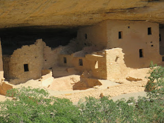
Spruce Tree House, another well preserved cliff dwelling was closed but I was able to get these telephoto shots from the canyon rim.


Sept 2 Mesa Verde on the Mesa Top


My objective on this trip was to immerse myself in the native american past of this region. The cliff dwellers get all the accolades but the lowly mesa top pueblos and cartoonish petroglyphs are way more prevalent here and left me astonished. Being from North Carolina, my experiences with native American ruins and relics are limited to their stone tools and points, the ryolite quarries of the Uwharries, a few fish weirs and some mounds from the Mississippian culture. Here, puebloan ruins are everywhere. Their pots and tools are so well preserved. In the cliff dwelling and some mesa top dwellings, the original wood used in construction is still intact. 


This low point on the mesa top has been encircled with a stone dam to impound water. There was a ramp and a staircase leading into the shallow reservoir. 


A kiva. What is a kiva? Every family, or extended family had a kiva which served as a kitchen, dining, living, work and worship room. Most are a round structure with an air shaft allowing outside air to circulate into the room. Note the air shaft opening in the photo above. Just in front of the opening is a rock which acts as a deflector to keep the air from going right into the fire ring. There are many holes in the floor. Some may have been for support structures. Normally, there was one which was a hole to the underworld which acted as a conduit for the spirits of the family ancestors to be present for ceremonial rituals. The kivas were all below ground level and would have had a roof like an upside down bird's nest supported by the buttresses along the circular wall. 

Entire villages often had a ceremonial kiva which would have been much larger and had other accouterments. Some had a secret passage in which some might have made a dramatic entrance. 


The mystery of the Sun Temple. One of the last structures built on the mesa tops of Mesa Verde, is this structure. Its 4 foot thick walls and beautifully crafted architecture leads some to believe this structure had some special meaning. It has a spectacular view of the canyon and overlooks Cliff Palace and other cliff dwellings. It contains about 30 rooms, has no roof beans, no household goods so it likely was never completed. 


Aug 1 Hovenweep


It's another National Monument with pueblo ruins - Hovenweep, again in the four corners region of southern Utah. Hovenweep is a deserted valley in Ute language. It was not until about 700 AD that people began to migrate into this area to live. They came in waves which precipitated building sprees. The last group to arrive was here about 1230 AD. And again, by 1300 they were gone.


There were several villages in this canyon near Cajon Mesa. Most are open to visitation but roads to them are marginal for many vehicles. Having already hiked up and down Sand Canyon, we opted for the easy 2 mile walk around the main village near the visitor center. Temperatures were in the triple digits again today.

Note the two styles of towers - square and round. These builders were quite talented.


The square tower above was located right at the spring of this canyon head, Its purpose is uncertain.


Driving back toward Cortex, we spotted a car parked alongside. On a whim, we stopped too and were rewarded with this rock of petroglyphs. Unfortunately, there was some modern graffiti and broken beer bottles also.

Sept 1 Sand Canyon


Sand Canyon pueblo is located within the Canyons of the Ancients National Monument. It is a 6 mile out and back walk. We opted to do only half due to the heat. The parking area is solid surface stone. It reminds me of Stone Mountain State Park in NC. 


The attraction here is you can hike along the canyon walls and see ruins at a number of sites. Most are just a wall or a few rooms but unlike Mesa Verde, you are on your own here.


Not much grows here which leads me to wonder how these people eked out a living. This four corners region was home to 70,000 people back in the 1200s. By 1300, they were virtually all gone. No one can definitively say why they departed. The best hypothesis I heard, was a shift in climate in the late 1200s. A severe drought appears at that time according to dendrochronology. Tree rings tell that story. There is also evidence the population was thriving and increasing in the presiding years. That may have stressed the natural resources. Limited resources likely would have caused community conflicts. There is evidence that the last construction around 1300 was defensive.


The progression of Native Americans in this area begins about 10,000 years ago, we are told. Those people would have been hunter gatherers who would have built only seasonal camps as they roamed in search of food and water. Judging by the size of their points, they would have hunted large mammals. We know that the Late Pleistocene saw the extinction of 33 out of 45 mammals exceeding 90 lbs in North America. The likely cause was overhunting. Many of these species lacked the instinctual fear of humans. Thus, hunting and killing these mammals was relatively easy until they grew fearful of humans or went extinct. It is difficult to say when agriculture began in Mesoamerica. There are reports of crops in the area over a period of years. I'm going with 2-3000 years ago. The 3 main crops were beans, corn and squash. Agriculture led to permanent homes. The first homes were pit houses, dug into the ground and used shallow stone walls supporting a wood structure above. Later construction sported stone houses with a wood frame roof. Finally about 1200, some people moved from the mesa tops to cliff dwellings in the alcoves of the canyons, like the structure above.


I'm still baffled by the lack of vegetation and hardness of the soil. This may look like sand but it is almost rock hard. Farming this land would have required water. There are check dams and even a reservoir for this purpose. They are all dry today. So has the climate changed here in the past 700 years to that degree?


Apr 20 Waterwall on Walker Creek

  Waterwalls redirect floodwater back into the creekbed. There is one very near the Uwharrie Trail on the Walker Creek section. This one is ...