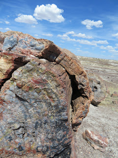
How does a tree turn to stone? I should know this. More than one interpretive sign explained the transformation. Permineraliazation is the process. A living tree falls and over time is covered with sediment before it has decomposed. These trees fell about 225 million years ago in the
Late Triassic Epoch. Once shielded from oxygen and the elements, decomposition is put on hold. Minerals percolate into the organic matter, eventually, minerals crystallize making a replica of the wood. Almost every piece I saw was in chucks like above. It looks as if the wood was chain sawed into these lengths.
The various colors are determined by the mineral. From Wikipedia - here are colors associated with the various minerals.
- carbon – black
- chromium – green/blue
- cobalt – green/blue
- copper – green/blue
- iron oxides – red, brown, and yellow
- manganese – pink/orange
- manganese oxides – blackish/yellow
- silicon dioxide – clear/white/grey
Here is the longest log I came upon.
Note how the outer bark mineralized as well.
As you look out into the desert, these lengths of petrified wood look like cattle. Obviously, not enough vegetation for cattle grazing here.
These eroded hills are called the Tepees. The large shallow ocean that once covered this area, formed most of the sedimentary layers you see.
Petroglyphs found in the National Park. No one knows what these mean. There was no written language. Very few are solitary. So, is it graffiti, a story, a doodle or an idea? Most are thought to be between 2000 and 650 years old. Humans made their first appearance here about 8000 years ago. Beginning 2000 years ago, pit homes and agriculture began.
The Petrified Forest National Park began as a National Monument in 1906 and was upgraded to a national park in 1962. John Muir was among some of the early conservationists advocating for protection. Protecting its resources has been a priority from the beginning.
The petrified wood is in the southern part of the national park. Once you cross over I-40 to the northern section, views of the Painted Desert appear. El desierto pintado, as Coronado named it in 1540. A small portion of the desert is in the National Park. The rest of its 7500 square mile area, is mostly on Navajo land in the four corners area.


No comments:
Post a Comment