Tuesday, May 29, 2012

May 30 Flat Top Mountain


This is a short hike on the carriage trails in the Cone Manor area. To the top of Flat Top Mountain and back it is a bit over 5 miles. The skies were cloudy but  we managed to see some great views in all directions. At the top is a metal frame observation tower which we are standing on. You are well above the treetops here.


There were a few bushes of Flame Azalea and some Catabwa Rhododendron. Other than that, a keen eye could spot some Bowman's Root, Fire Pink, Virginia Waterleaf, Spiderwort, Smooth Solomon's Seal, False Solomon's Seal and various other flowers.

May 27 MST Price Park to Blowing Rock


Today's hike ended up being 14 miles. I made two wrong turns and that added a bit over 2 miles to my hike.    
Beginning at the Price Park picnic area off the Blue Ridge Parkway, I start walking on the Boone Fork Loop Trail. It is an easy stroll along the creek for a mile and one half. At that point the MST deviates from the loop trail, crossing Boone Fork. Even in dry weather it looks like this is a wet crossing. Knowing this, I have my creek crossing sandals ready. The water is about thigh deep today. There is a very pleasant fellow hiking with his daughter on the opposite side. He tells me he owned and ran the Victorian Inn in Blowing Rock for two years. That seems to be a common theme among inn owners - 2 years.

Indian Cucumber Root

The MST is blazed or so I thought, so there was no need to print out the trail description. One of the first thing I did was make a wrong turn which added 2 miles to my walk. I somehow ended back up on Shulls Mill Road and found the turn off for the trail. At this point the climb up Rich Mountain combined with the heat and the fact I'd added extra mileage, took its toll on me. I stopped mid-trail and took a water and energy bar break. Beyond here, the trail connects with the Rich Mountain trail and drops to Trout Lake before heading to Cone Manor. 


At Cone Manor it is still 5-6 miles to Blowing Rock via the MST. There are more direct routes on the park's carriage roads but the MST follows lessor traveled carriage roads with innumerable swithbacks. The finial approach to Blowing Rock is along a dirt road emptying onto Rt 321. I'd hate to pull pull out in a vehicle at this point. It is a blind curve and cars are travelling fast. The last 1/2 mile in in the road gutter.

Monday, May 21, 2012

May 19 Grandfather Mtn Profile trail


This PHOC hike led by Debby Harris, began at the Profile Trail trail head on Rt 105. Three state park employees were present to handle parking chores. Apparently, this parking area fills every weekend without rain. Once the parking area is full, there is no other place to park unlike the other side of Grandfather State Park where one may park along the grassy side of the Blue Ridge parkway once the parking areas are full.

We had 12 in our group. The Carolina Berg Wanderers from Charlotte also had a small group leaving about the same time. The Profile Trail starts in Rhododendron, crosses a few creeks and head steadily up. The tread way is quite rocky and heavily eroded in many spots. So much foot traffic passes this way, several alternate bypass trails are appearing and furthering the erosion.

One of the highlights of my day was listening to the mysterious down spiraling song of the Veery. I heard it on the way up and down. I still need lots of work on the warblers. I could identify only the Black Throated Green. Oh, and Ovenbirds. 


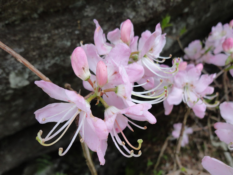
Above is Pink Shell Azalea. It has an almost solid pale pink bloom. We spotted several bushes in two spots. Pink Shell only grows in 4 western North Carolina counties where there are less than 100 communities. It does seem to be a hearty plant though, surviving in some rough terrain. I understand it grows only in spruce/fir forests and only 3000' to 5,500'. I believe that we saw some at about 5800' just below the last ladder up MacRae Peak. 


Fascinating is the geology of this area. The scene above is typical of the area surrounding MacRae Peak and  the middle peak known as Attic Window Peak. The terrain one must traverse to go from peak to peak to peak is littered with giant boulders. A series of ladders helps hikers navigate the steepest sections. The photo at the top of this entry shows the "chute" as folks call it. It is a steep rock cut with limited hand and foot holds. Our final stop was Calloway Peak, at 5946' the highest of the three by just over 100 feet. Here we heard the croaking call of the Ravens. One soared overhead looking every bit like a Turkey Vulture until the unmistakable Raven profile came into view.


One of the prettiest mountain flowers is Sand Myrtle. The tiny buds are pink, then flowers white. Although tiny, it makes an impressive sight when the whole bush blooms.

We all managed to make it down the mountain trail with the usual scrapes and bruises so common in this terrain.

Friday, May 18, 2012

May 17 Deep River Birds


Deep River: Ramseur to Coleridge, water level 2.6. Great day to be on the river. Temperatures in the 60's for our float. There is something different about today. Since I have taken up birding by ear, a new dimension to this trip is revealed. I heard bird song for the entire 6 or 7 mile float. Most I could not identify but I learned a few. 

If you are a birder, this is the place to go. The trees lining most rivers are original. The trees lean into the river and thus are not candidates for harvest. they are however, great locale for birds. 


Here we are at the island we always stop at. It was inundated with water today but I managed with my creek sandals. The forest opposite this spot has been clear cut as you can tell from the photo.


Our take out spot is in jeopardy. John had made friends with the owner and received permission to cross his property to take boats out. the new owner also seemed amenable but John thought this fellow's son didn't want anyone around. We'll see how this plays out. Options are limited.  

Sunday, May 13, 2012

May 13 MST Beacon Heights


Hemlock Varnish Shelf polypore found along the MST below Beacon Heights. This should be a familiar sight even more so in the near future as we will have many more decaying Hemlocks. 


The Three Top scramble for today was cancelled - rain in the forecast. I managed to walk this nice trail from the parkway to a forest service road and back. There weren't many wildflowers to see but I did manage to spot this small Lady Slipper display.


The sky was clear when I began at 7 but looked like this 2 hours later.

May 12 Tanawha Trail


It is always fun to hike Tanawha Trail. When the opportunity presented itself, I jumped. At 13.2 miles this trail seems like a longer hike. I suspect the rough terrain from Beacon Heights to Rough Ridge makes it seem that way.


We saw lots of Speckled Wood Lily and even some Clinton Lily. I was under the impression Clinton was found at higher elevations but we saw a patch which contained both. It is hard to say when the peak Rhododendron bloom will occur. We saw some blooming but also saw many damaged buds. This could be a less than stellar year.


Toward the end of today's hike, just before passing Holloway Mountain Road, we encountered a group of young persons atop a hill in a cow pasture. They were rolling barrels and some of the girls were wrapped in blankets. One fellow had a guitar. Any guesses? They were doing a photo shop for an upcoming wedding. The barrels were used to stomp grapes. The girls in blankets or togas were the stompers. We didn't notice any juice stained legs though. You see all sorts of wildlife out in the woods.

May 10 New River Trail Bicycling


Today's ride begins in the tiny riverside town of Fries. In the photo above you can see the New River is dammed. A textile mill, Washington Mills used the dam to power its early operations. The mill closed in 1989 but the dam still generates power.

It is early morning and mist still lingers over the river until air temperatures rise. The first mile of trail passes by the community. Then the trail crosses a paved road and enters the forest along the river.


On my way to the Shot Tower I pass two other dams. Both owned by Appalachian Power. This section of the river drops quickly as evidenced by the photo below. Also the reason for the dams being placed here.


A lot of rain fell yesterday and the side creeks and puddles are full. There was even a tree down across the trail so there may have been some wind associated with the rain. Most likely it was a cold front as temperatures stay low all day.


It seems every pair of Canadas has a newly hatched brood to look after. I see two in the trail and several more swimming in the river. As the day passed I saw more bicyclists but probably did not see any for the first 2 hours. Not long after that I encountered about 200 school kids out enjoying an outing on the trail.

Thursday, May 3, 2012

May 2 Grandfather Lite Hike


I could have titled it "Bad Hair Day at Grandfather" as the wind blew stoutly on us, but only while exposed on the Cragway Trail. Three of my favorite hiking companions made this impromptu journey out of the Piedmont into the spring-like environment of the High Country. 

Grandfather Lite refers to easy route up to Calloway Peak, at 5946' it is the highest point on Grandfather Mountain. Still, "easy" perhaps should be qualified. There are some spots with rock scrambling is required and there are 3 ladders to negotiate.  However, once on top, the view for lunch is unsurpassed. On weekends, it is hard to get a seat in this restaurant.


Painted Trillium punctuated the hike. Their smiling faces eased the effort some. We also saw many Trout Lilies in bloom, some Wake Robins as well as the usual suspects, Spring Beauties, Star Chickweed, Smooth Solomon Seal and a few I don't recall. 


The real thrill of this hike came on the return. A Ruffed Grouse sped off from next to the trail. Then I noticed the nest she had been on, with a dozen eggs. The eggs were about the size of a very small chicken egg. I hope she returns.


Sunday Night Pizza


Experimentation continues on the pizza crust with this 3/4 white and 1/4 whole wheat (red) dough.

This pizza sports some great toppings - ramps, chanterelles, ground beef, fresh tomatoes and brie instead of mozzarella. 

Tuesday, May 1, 2012

April 27 Goshen Prong Trail


I was not registered for this hike but somehow ended up going on it. The logistics were to meet at the ending point in Elkmont at the parking area for Little River Trail. The parking area was littered with broken glass, a result of car cloating. From here were we driven by van to the parking area for Clingmans Dome. From there is was a nice 13.2 mile walk, almost all of it downhill.


I chose to keep the birders company at the rear of the peloton. It was a real thrill when the sweep, Meredith called in, phished, a Chestnut Sided Warbler to within 15 to 20 feet. What a gorgeous bird. I felt lost among the experienced birders who knew all the warbler calls, the Mountain Wren, the Junco - OK the Junco is no big deal.


We followed the AT for a couple miles meeting a fair number of "Thru Hikers". Once we turned on the Goshen Prong Trail, the backpackers ceased. This is a tremendous pathway with creekside vistas, waterfalls and lots of wildflowers. Once we left Goshen Prong for Little River Trail, we were treated to more flowers and a larger riverside with waterfalls. Even at the 13.2 mile mark I didn't want the hike to end. It was 5pm and I bid adieu to my companions. There were still a couple treats on the return drive. The flowers below were roadside by the old Wonderland Hotel. there was also a yearling (bear) causing a stir adjacent to the Laurel falls parking area


April 26 Cat Stairs


As everyone arrived in Greenbrier, the heavens opened and lightening bolts from the darkened sky menacingly dared us to climb the Cat Stairs today. As we began up the manway near Bird Branch it was still spitting rain. Due to the wetness I did not take but one photo today (above). The photo below was taken in 2007 on a previous visit.

A well worn but unmaintained and unnamed trail led to the homesite of John Barnes and his family. Our leader, noted author and historian, Ken Wise described John as odd and a loner. The small graveyard just down from the cabin site spoke volumes of how hard life was just 100 years ago. Three daughters aged 1 to seven are found in their final resting spot. One born on Christmas and another died on another Christmas.

Beyond the Barnes' homesite, the trail continues in much better condition than my 2007 visit. We reach the spot where the ridge, known as Greenbrier Lead, begins us on a real off trail experience. There is a manway through here. Perhaps several manways is a more aptly put description. Steepness increases until you reach what I refer to as the stairs. Here it is a almost vertical climb. We are tested in the wet conditions. Some of us manage quite well in this terrain and others need assistance. In the photo above, we have to use a large hiking staff to pull folks up the slick gully.  


Lunch is enjoyed in a beautiful setting between two vertical climbs. Here is the view as it looked in 2007. While we eat, clouds move in and I become apprehensive about the possibility of climbing in a downpour. That does not happen. The hail started after we reached the top. We were pelted with mini marshmallow sized hail with a few approaching regular marshmallow size. Fortunately, we are in a rhododendron tunnel most of the time which shields us somewhat. Still, a few did sting me. 

Several of us decide to hurry on down the mountain (Greenbrier Pinnacle) and retrieve some cars to shortened the hike for the others. It is still about 5 miles to go. What a great hike and great company. 

April 25 Fork Ridge & Deep Creek Trails


My first hike this year with the Spring Wildflower Pilgrimage reacquainted me with familiar faces. Our hike was led by Doris Gove, noted author, naturalist and hiker. Many entries in the Smokys Hiking Guide (the little brown book) were penned by Doris. Our sweep was Dee Monty, fond of the ferns she is. Randy from Durham was another familiar face. We began hiking on a snowy trail off Clingman Dome Road. We descended and descended. Flowers came and went as we changed elevation. 


Deep Creek marked the bottom of the hike. Water level was high enough, we had to walk barefoot through the frigid creek. At the creek crossing there is a backcountry campsite where we enjoyed lunch. The photo below shows a fairy home creekside. It was part of a much larger fairy community reminding one of the fairy homes found along the Maine coast. 


From the creek it was a long gradual incline to Deep Creek trail head on Newfound Gap Road. Total length of our hike was only 9 miles but having the climb at the finish made it seem more. The forecast for tomorrow doesn't sound good.

April 24 Meigs Creek


Indian Turnip or Jack in the Pulpit are found in damp areas along this trail. These examples are nicely streaked. Many do not have the dark streaking seen here.


Meigs Creek Trail begins at the Sinks parking area. The first hundred yards or so of the trail sees heavy use as a result. Walk uphill for a way and the traffic thins to a trickle. If you walk the full 3.5 miles you'll be treated to a variety of plants, flowers, large trees, dead trees (Hemlocks) and 20 creek crossings. A round trip boasts 40 crossings. A couple presented some interesting challenges.


Today, Dog Hobble was flowering. Nearby areas were fragrantly scented. I walked through many such areas. Vasay's and Wake Robin Trillium were in bloom and the waning moments of Catesby Trillium blooms could be seen too.  


A stretch of trail about a mile in boasted some Pink Ladyslippers. I ate lunch with these ladies.


April 23 GSMNP Headquarters at Sugarlands


As you exit the Great Smoky Mountains National Park into Gatlinburg, you are greeted by this magnificent building, park headquarters. The scene above is the one you see driving north on Rt 441 or Newfound Gap Road. Built during 1939 and opened in early 1940, it served as park headquarters and visitor center. In 1960 and new visitors center was constructed. Locally designed, many of the construction material were also sourced locally. The exterior limestone block were quarried at Ravensfork in North Carolina. Light fixtures hanging from the lobby ceiling were fashioned from a salvaged skidder once operated by the Little River Lumber Company. Funds to build the structure were provided by the WPA with some of the labor coming from WPA and CCC. 


April 21 Hanging Rock


Today's hike visits the namesake of Hanging Rock State Park, Hanging Rock. The photo above is looking west from the top of the rock. The photo below looks northwest toward Moores Knob and Indian Face.


Located in Stokes County, NC, Hanging Rock State Park was once privately owned and considered to be a great location for a mountain resort. Popular resorts already existed in the area benefiting from the mineral waters of Moores Spring, Piedmont Spring and Vade Mecum Spring. The former two date back to the late 1800's and the latter to the early 1900's. Popularity began to wane in the 1920's as automobiles could take vacationers to farther and previously inaccessible places. That is about the time the area now Hanging Rock State Park was being considered for development. The venture went bankrupt and the land found its way to the State of North Carolina and became a state park. Early park buildings, trails and the lake were constructed by the CCC. Remnants of the camp still exist in the group campground located near the park's entrance. One of those structures, the bath house on the lake is now on the National Register of Historic Buildings.


This flowering Fringetree can be found on the trail to Cook's Wall

Apr 20 Waterwall on Walker Creek

  Waterwalls redirect floodwater back into the creekbed. There is one very near the Uwharrie Trail on the Walker Creek section. This one is ...