Sunday, January 24, 2016

Jan 20 Cumberland Island


The southernmost of Georgia's Golden Isles, Cumberland Island has escaped, for the most part, development which has swallowed up other Georgia islands and Amelia Island, Florida to the south. Human habitation began centuries ago. There is little or no evidence Native Americans inhabited the island more than 4000 years ago. Prior to that, shorelines would have extended farther east onto the continental shelf. In some places as many as 70 miles east in the time period going back 20,000 years, when it is generally accepted, migrations of nomadic people began coming to North America. Roughly 4000 years ago, the shorelines became stable to their present location. Little is known about the first inhabitants. there is more evidence in the period extending back 1500 years. These people were Timuruan. More specifically, the Tacatacuran tribe. Early Spanish writings reveal the existance of 6 villages on the island with the main one, Tacatacura on the southern end. Their name for the island was Wissoo, meaning Sassafras. They were mound builders and constructed mounds of shells. Pottery shards and shell middens have been found, as well as exiting mounds, mainly on the north end.

The first Europeans to arrive, came in 1513 as Ponce de Leon passed by. Later in 1562, French came and befriended the Indians. Shortly thereafter, in 1565 Governor (of La Florida) Pedro Menendez expelled the French and in 1569 built a fort and called the island "San Pedro Island". By 1587 a mission had been established and the Spanish attempted to convert the Indians. In 1597 a raid by Guale Indians destroyed the mission. In 1603, the Indians had rebuilt it and in the next century the Franciscans had two more missions on the island. Their system began to fall apart in the 1680s. Pressure from the English and raids by both French and English privateers forced the Spanish abandon. Finally in 1742 they were repulsed for good. James Oglethorpe, founder of Georgia, named the island for the Duke of Cumberland. Spanish claims to La Florida came to an end in 1763 with the Treaty of Paris. Georgia attained statehood in 1787. 


After the Revolutionary War, American war hero, General National Greene of the battle of Guilford Courthouse fame, bought a huge chunk of the island. He was eyeing the Live Oak trees which were in high demand for ship building. The curving branches were used in making ship parts which needed curved timber like angled supports. He moved there with his wife Caty in 1783 and began building a huge structure. Using the mounds of shells left by the Indians, the structure was constructed of tabby, a mixture of shells, sand and mortar. Land was cleared to grow cotton. Greene's dreams were cut short upon his death in 1786. His widow later married Phineas Miller. They lived in the tabby home, named Dungeness, grew cotton, sold Live Oak timber and never got out of debt. Caty, throughout her life, attracted men. She is known to have been linked to Alexander Hamilton and Aaron Burr. How did that one end? She also became a business partner, and possibly more, with Eli Whitney, who liked the ladies as well. Caty is now credited with suggesting Eli use a comb in his famous cotton gin. The story of the cotton gin is an interesting one, worthy of another day's blog.

Phineas dies, Caty dies and Dungeness becomes the property of Caty's daughter Louisa Shaw. Close to death, one of National Greene's wartime friends, General Henry "Lighthorse" Lee (father of Robert E Lee) comes to Dungeness and is nursed by Louisa until death. I saw his grave in a small cemetery, although his body was removed in 1913, moved to Lexington Virginia.


By the Civil War, the island is almost deserted. The union uses it briefly. The 13 plantations are gone. The union soldiers are told to not destroy Dungeness but it is burned in 1862. It is blamed on "drunken debauchery". 

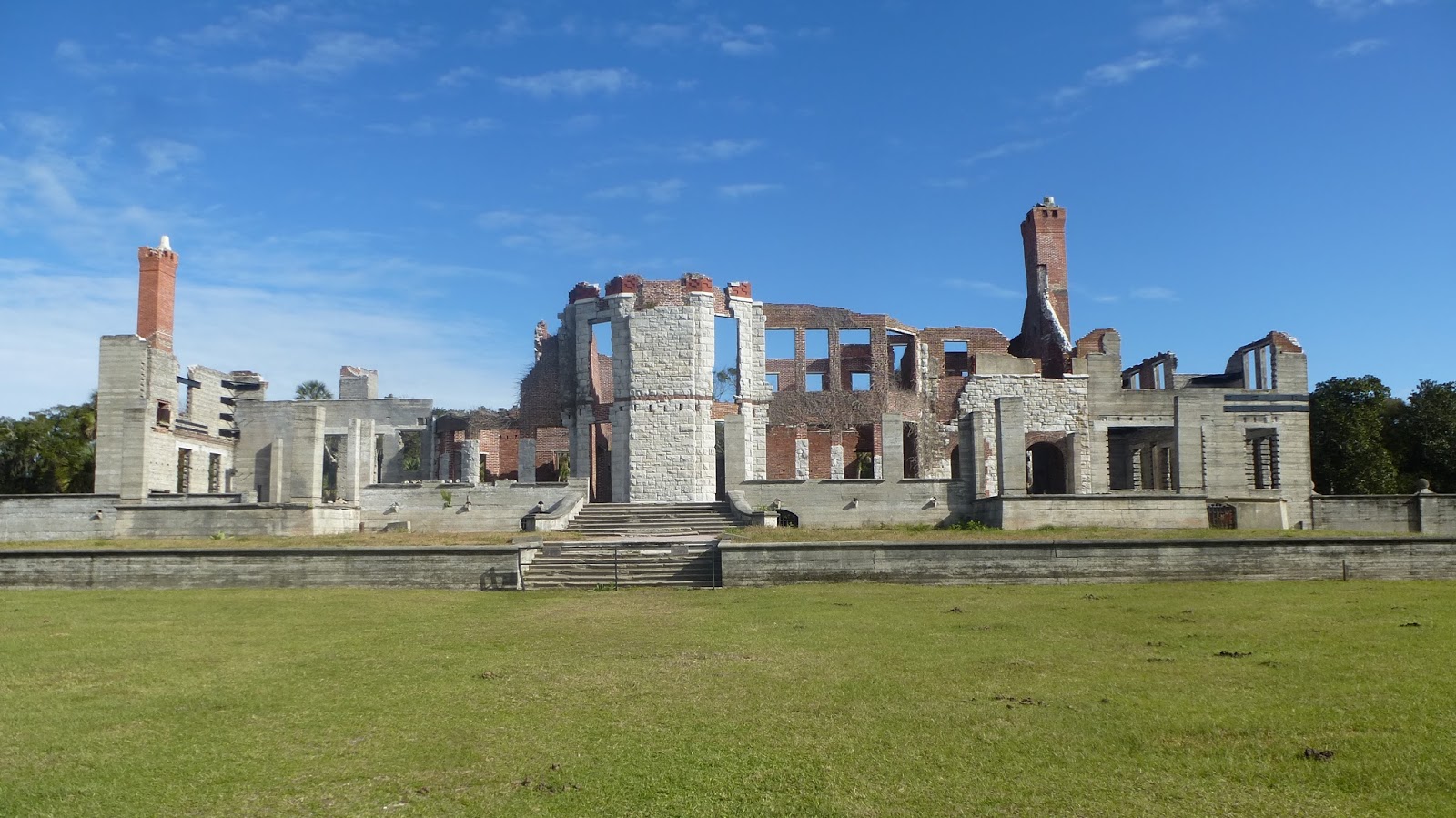
In 1881 Thomas Carnegie, brother of Andrew, buys most of the island. He builds on the ruins of Dungeness, another Dungeness. This time in grand style as was common among the elite of the Gilded Age. He dies in 1886, leaving Dungeness to his wife Lucy Coleman Carnegie. Coleman as in Coleman camping gear. Thus, the lineage of Carnegies (now Fergusons) continue to today. They built Plum Orchard, a mansion not a grove of fruit trees; Greyfield, now an inn operated by Gogo Ferguson. 

Gogo arranged John F Kennedy Jr's wedding to Carolyn Bassette in the tiny and sparce African American church on the north end of the island. It was very private and secret. Kennedy forgot his shirt and had to race back at breakneck speed via the beach to retrieve it.

Later he and Gogo proposed to the NPS, that they would finance the renovation of Plum Orchard as a artists' retreat. That proposal was rejected.


Enough of the history lesson. I arrive via the NPS ferry from St Marys Georgia. The walk to the ruins of Dungeness are nearby. Even the ruins are grand. Wild horses roam all about. The NPS doesn't really want them there. They eat cord grass and trample it, causing salt marsh erosion. No one is certain where the horses came from. They can't be linked to the Spanish, so probably, early English. The wealthy inhabitants have brought their own Arabian and other breeds which interbred with the feral houses. I think I saw a couple which looked like they had some Appaloosa genes.  


The Carnegie Dungeness burned in 1959. No evidence except circumstantial has been found. The caretaker shot a poacher. The poacher survived after a hospital stay. Not long after his release, the Dungeness yacht sank and the mansion burned.  

A look inside the Gilded Age


You can easily run the battery down just taking photos of the feral horses. They are everywhere. I did not see any on the beach since there is nothing for them to eat there.


After viewing the ruins, I continue to the beach, over the dunes. This stark scene is typical. Below, I pass an Osprey eating a fish. It is holding the fish on the branch and leisurely consuming it.


Now it is my lunchtime. A lone Ringbill kept me company, hoping to get a handout. Once I sent a piece his way, other Ringbills decided to join in. My buddy did his best to keep them away.

17 miles of deserted beach


After walked 2.5 miles of beach, I went inland. The NPS has several spots marked where one can cross the dunes. Little Greyfield Beach is where I crossed. From there I hiked on trails to Stafford Beach and the campground there. 

Stafford Beach

Main Road

Violet Wood Sorrel


Returning via the main road was the quickest method. I needed to catch the 4:45 ferry at Sea Camp. A blister was forming so I didn't deviate much from this return route. If a vehicle had come along, many spots offered, literally, no where to get off the road. The Saw Palmetto was so thick, you could not get past it. For about an hour, no traffic passed. Then, a few cars came along but I was able to get to the side each time.


Awaiting the ferry at Sea Camp, we all gathered for the return to the mainland. I spoke with a local gal returning after preparing a local rental for group of hunters. She told me, most of the private homes had been turned over to the NPS. All the remaining have agreements of varying lengths before they too are transferred.

As the boat headed into the sun, a group of White Pelicans is spotted. A fitting end to day.

Saturday, January 23, 2016

Jan 16 Corkscrew Swamp Sanctuary


 Corkscrew Swamp Sanctuary derives its name from the Corkscrew River and the fact it is a sanctuary for plume birds. Audubon Society acquired the property while it was being used as a hunters' camp for birds whose feathers were sold to adorn ladies hats. Audubon hired rangers to police the property. Snowy Egrets, Roseate Spoonbills and Flamingos were the hunters main targets. The virgin Cypress was also slated for timbering.

Today, the sanctuary sports a 2.25 mile long boardwood made of sustainable rain forest wood which resists rotting and does not contain chemicals found in treated wood.


The ancient Cypress trees are as much as 500 years old. most are covered by this parasitic vine. Resurrection Ferns grow on the Cypress limbs. They also support other plants including the Ghost orchid.  


Looks like prime Alligator territory. I was told by a local, a 14 foot gator owns a nearby area and can often be seen sunning on a small island. I did not see it. I did see otters scooting nearby. I think that would be a tasty meal for a gator.


This Water lettuce covers this area. It is a great bird watching spot. I saw a Little Blue heron, Kingfisher, Yellow and Black Crowned Night Herons, White Ibis and a Green Heron.


Jan 13 Hillsborough State Park


They call this a class II rapid. The only one in central Florida. It is a scenic river with a few little riffles like this, surrounded by Cypress trees and knees.


It definitely looks more menacing from this from this angle. The Cypress knees look like gnomes lining the river to guide you through the rough water.


Just feet from the river's edge, the Cypress gives way to Saw Palmetto and Sabal Palm. I also saw a rouge Orange tree which squirrels had feasted on. I tried one. It was rather seedy but very tasty. 


There are several miles of trail to a backcountry camp. I saw some feral swine on the way. Once away from the river, I was walking through Live Oak with the requisite palms.


This Red Shouldered Hawk was having lunch in the picnic area.

Jan 12 Withlacoochee Trail


Florida has straight roads and straight trails which were straight railroads. This is no exception. It was originally part of the Plant System. A distant relation, Henry Plant developed a railroad along the west side of Florida to compete with the east coast railroad of Henry Flagler. Two Henrys!

From Wikipedia

A little more hair than I have. Ok, a lot more hair than I have. Builder of today's Rail Trails.


This fancy gate along the trail caught my eye. They look like dogs but are horses decked out in holiday attire.


We ride under I-75. It is near here, where you can take a short trail to the Withlachoochee River. It is surrounded by Cypress swamp and is dark with tannin. The river is a state paddle trail. 


In Inverness I stop for something to eat. A very nice bistro is near this caboose. I chose to eat on their porch which sported an opportunistic squirrel. I'm sure the little guy would have taken off with my sandwich, had I not been on constant vigil. The town also has several motels which could have made this a two day ride. At 46 miles, I only rode a bit over half. The scenery was quite diverse. Near Inverness, I am riding in a big town. I also rode through very tiny ones and lots of rural and forested land.


A great example of heart rot on a massive Cypress tree. This swamp was near the river. Althoug the river was always close, it was never visible except via spur trails.


What does the "R" stand for. I'm guessing Richmond. And it is 817 miles distant. 


This angular bridge crossed a multi lane highway near Manor Ridge. There are many motels and restaurants about 2 miles from here.

A fifty miler in January!

Jan 11 Rainbow Springs


It is said Rainbow Springs produces 400 million gallons of water daily. Its water comes from a 700 square mile watershed. The water here today was 72 degrees. It is perfectly clear to the eye at the source. As the water makes its way to Tampa, it gets less clear and finally murky, stained with tannin. 


Before Disney World, Florida had several home grown water based attractions. Rainbow Springs was one. They hired mermaids to swim in the clear water next to a sort of submarine boat which visitors viewed below water level scenes. There was a rodeo, above ground; a zoo, herb garden and waterfalls. Could there be waterfalls here.


Yes, waterfalls are located throughout the park. They just aren't naturally occurring ones. Rubble left over from phosphate mining, was used to create the falls along with fresh spring water pumped up to the top of each. Once Disney World opened, Rainbow Springs attraction folded and it became a state park.

This guy paid no heed to the "NO FISHING" notice.

Jan 10 Gainesville to Hawthorne State Trail


Today's original plan was to bicycle the entire trail but due to the freezing temperatures in the morning, I had to wait until early afternoon before undertaking the ride. Getting to the trail from Gainesville, required google maps on my phone. Having done that, I pedaled off, only to end up on a dead end spur trail. Finally, back on the right track I rode as far as I dared before turning back. Darkness occurs early, so I didn't wish to ride in darkness with no light.


Much of what I rode through was mixed forest. However, this section had some scenic Cypress swamp. No critters were spotted except one Armadillo. This guy lived in a hole dug under the trail pavement.

Jan 10 Paynes Prairie


Paynes Prairie is a series of ancient sinkholes which have formed into a lake with lots of wetlands. It is just south of Gainesville Florida. In the 1880s, flooded created a real lake. Since then it has receded to be shallow lake with wetlands. The wetlands are great habitat for Sandhill Cranes. They were quite noisy during my visit. 

At several spots around the lake are observation towers or raised platforms. One was not accessible due to some flooding. The other two were available. One was behind the closed visitor center. It was three stories and where I took the Spanish moss photo above. The second was at the end of a mile and one half trail. I hiked out to that one but upon nearing the platform, an alligator lay in the trail. It was a raised trailbed with water on either side. I could see the platform just beyond the snoozing gator. It is fortunate I didn't arrive earlier and possibly get stuck on the other side. That could have been a very long Floridian standoff.


Anhinga in a tree. Birds were plentiful in the area. I spotted several long barreled camera lenses. All were gray or white headed. Several of the birds I saw were so close, the long lenses wouldn't have worked. 

Dead end trail

Red Shouldered Hawk

Jan 7 Hike up Hannahs Creek


Several weeks ago, I hiked alongside Walker Creek. It turned out tho be a great experience. I hoped to repeat the adventure by doing the same alongside Hannah's Creek. There was one big difference. Hannah's Creek has been explored and camped upon for years. Walker Creek has been in a remote and infrequently visited area.

After stopping at the Cooper Mountain Cemetery, we walked to the creek, passing this pile of rocks. Once at the creek, there was a large campsite with stick bench, torches and a dog line. 


This shelter was typical of what we found in various spots along the creek. Further upcreek, the terrain changed and camping was less desirable. 


Shortly thereafter the creek valley narrowed forcing us to climb high, in the vicinity of Bighams Graveyard. Beyond there it began threatened to rain and we gave up our exploration. 

Apr 20 Waterwall on Walker Creek

  Waterwalls redirect floodwater back into the creekbed. There is one very near the Uwharrie Trail on the Walker Creek section. This one is ...