Wednesday, May 26, 2021

May 22 Sparkleberry Swamp


We set out into Sparkleberry Swamp, the upper reaches of Lake Marion. The lake was created in the 1940's by an 8 mile long dam with 62 gates. It backs up the Santee River which is formed at the confluence of the Congaree and Wateree Rivers, now underwater. At 110,000 acres, it is the largest lake in the state. We put in at the Sparkleberry landing into the area called Sparkleberry. 


Of course you are wondering about the name. John Cely tells us the blueberry like shrub grows nearby but not in the swamp. 

We paddle in and out of open water. The boat ramp also attracts a few dozen pickups hauling jon boats. We can hear them coming for a half mile away. Most slow down but a few want to "wake" us.


Soon, we are tucked away in a maze of Swamp Tupelos. The water is brown. John tells us it is usually black but the recent weeks of little or no rain have settled the water. Swamp Cottonwood seeds float in the water everywhere. The windborne seeds are contained in what looks like natural cotton balls.


This swamp changes. There can be times during little rain that you can walk through here. There have been yearlong droughts with no water. The Swamp Tupelos need about four years to grow high enough to survive in the water. So a four year long drought could create conditions that would close up this swamp.


That looks like a cabin out here. It is actually a house boat. John says there are a couple dozen out here, permanently anchored. They are frowned upon and efforts have been made to remove them. Authorities have threatened to burn them but they are still here. 


The Swampmaster

Swamp Cottonwood seeds


When the 110,000 acre was created, the land had to be cleared. Some of the old growth trees were not cut, for various reasons. We saw a few of them. They dwarfed the second growth forest we paddled through. 


Our route was a 5 mile loop which took about 3 hours to complete. On our final leg, we saw a very large group of kayaks. They were from Charleston area - the Low Country Paddlers. 


About 1pm, we paddled to the boat ramp, pulled the boats out of the water and began to drive home. It was a very special paddle in this swamp today.


May 21 Congaree's Big Trees


The meter indicates we should have a nice day in Congaree National Park. It was a outstanding visit. Our guide for the day, John Cely, met us at the Harry Hampton Visitor Center early in the morning. All the employees and volunteers knew him and spoke with him. One of the rangers gave him a report on the previous night at the park. It is synchronous firefly time and the park is closed to only those with lottery slots after 4pm. Just 25 cars are permitted in the park. There is a designated trail to follow after dark. Everyone must use only low level red light as needed to walk. There were makeshift curtains at the parking lot to limit car light. From the report given by the ranger, it was a nice night with a number of international visitors in attendance.


I didn't know the credentials of John Cely beforehand. After a few minutes with him, it was apparent that he knew this place intimately and perhaps better than anyone else. His first visit was as a young sophomore at Clemson in 1967. He had read about the swamp and Harry Hampton's efforts to preserve it. He got in touch with Harry and got his initial tour. Ever since, he has been spending time here. 


Francis Beidler bought the land in 1881. It was part of a 165,000 acre holding. Beidler did some timbering but changed his mind in 1915 and suspended logging. After his death, his family began logging again in the 1950s into the 1960s. It was Harry Hampton who led the charge to try to protect the area. The government did acquire a sizeable tract and it became a National Monument and later a National Park. The Beidlers were allowed to continue operating a fish and hunt club until the National Park was established. So, when John Cely first began exploring here, there was a road, now the Sims Trail, to a hunt camp on Cedar Creek. We saw the site of the camp. John said it was a first class place. The road, back then, was lined with magnificent Lobollies. Those trees succumbed to Pine Bark Beetles and are no longer there. 


John is good at spotting snakes. This one is a water snake. He says people confuse it with the Cottonmouth because it has a triangular head. Apparently, some water snakes have that triangular head as well. He says the snake population has declined significantly due to the feral hogs that roam the park. Hogs eat them. 


The trees are large here. It is their height that is really impressive. There are many state and national champions. Those titles change often as there are so many researchers measuring trees everywhere now. John states that the big trees here often lose the title to trees that are not in a forest. Forest trees grow tall to compete for canopy space but field trees grow fat. A champion is determined by height, girth and canopy spread. This puts forest trees at a disadvantage. 

The Loblolly kids


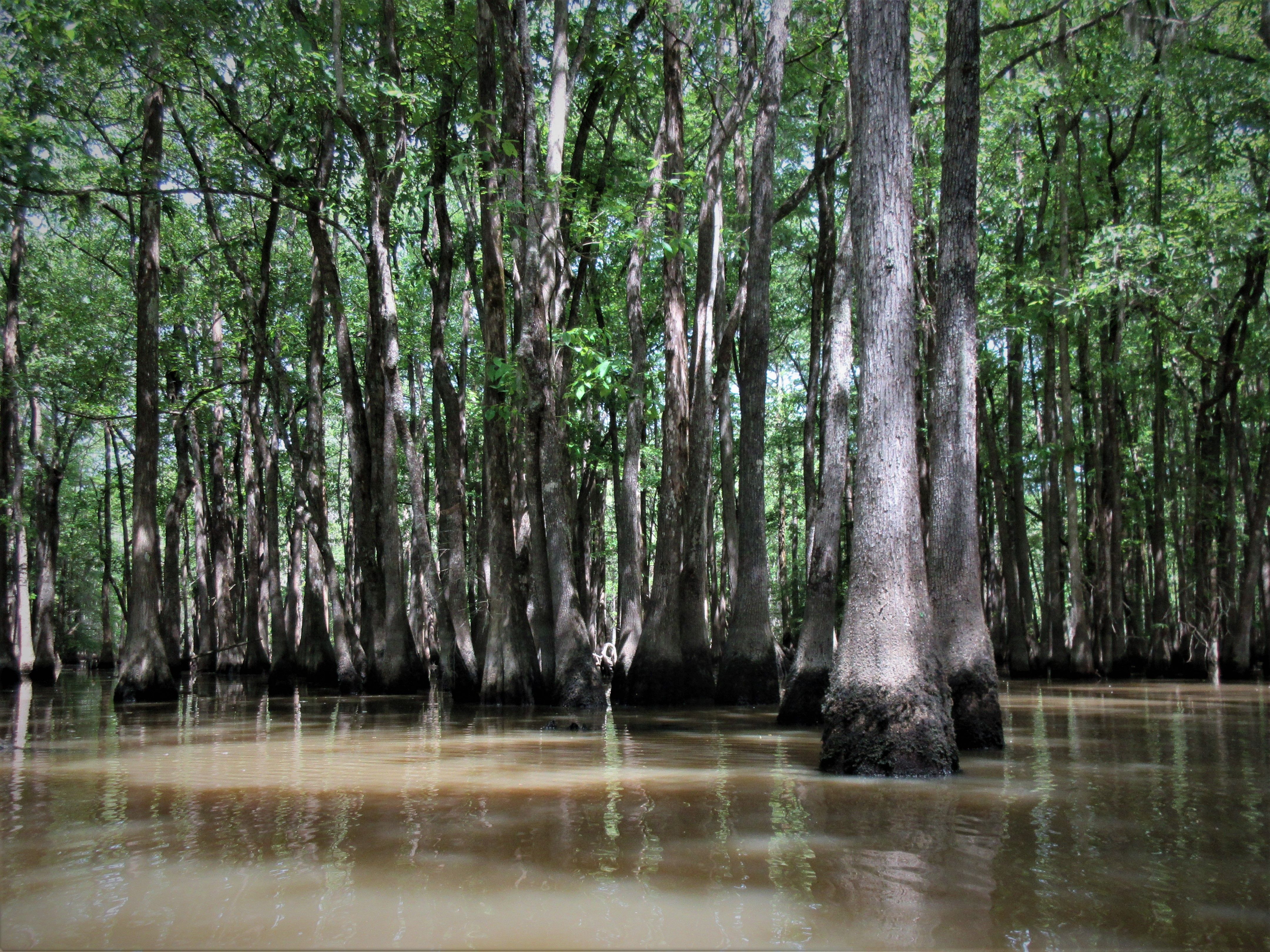
We saw many Water Tupelos as we walked. There were some Bald Cypress. Then the other trees started making a presence - Red Mulberry, Cherrybark Oak, Persimmon, Hornbeam, Holly, Beech, Paw Paw, Overcup Oak, Green Ash, Swamp Chestnut, Sweetgum, Sycamore and a few more. 


There was one area along the boardwalk that had lots of sunlight. These Forest Tint Caterpillars eat the leaves defoliating the trees. They do not eat the Cypress but make there cocoons on the Cypress leaves.  


John's decades in the swamp and forest have given him a unique perspective on how things have changed here. Of course, ceasing logging operations and the eventual conservation of the land, had a profound effect. Then in September 1989 another profound change began to take place. Hurricane Hugo made landfall near Charleston and roared through this area on its way to the other Charleston, in West Virginia. Wind gusts of 90 mph, previously unheard of in this area, tore the tree tops out and blew others over. I traveled through this area a few days after Hugo and it looked like every pine in SC had been damaged. The hurricane opened up the canopy and things began to change. Undergrowth and thickets began to take over the ground. What was open and an easy walk through, became littered with obstacles. Invasives found a place to get a foothold. We saw Japanese Stiltgrass and Privat on our hike.


Indian Pink


John got a kick out of measuring trees and letting us guess the circumference. I think this one was 17.1 feet. 


We stayed on the trail for most of the hike but John seemed to know exactly where to step off into the forest to find the next big tree. Our 4 hour tour came to a close. John asked what we were doing with 3 kayaks tied to the car. Suddenly, John suggests he guide us through the Sparkleberry Swamp on Saturday. 

Wednesday, May 19, 2021

May 7 Lake Lure Flowering Bridge


Another visit to the flowering bridge. It seems different every time. 


May 7 Eagle Rock


Everyone knows Chimney Rock, especially the "attraction". The outlying areas of the state park, across the gorge don't get much attention. Eagle Rock has parking for about 8 vehicles and is a climbing destination. It is at the end of a curvy, dead end road. The final 1/4 mile is a very narrow gravel road with large gravel.

Eagle Rock is less than a 1/2 mile walk. You can continue on the Weed Patch Mountain Trail and end up in Lake Lure (the town not the lake).


Bleeding Hearts are found at the rock.

Looking toward Mitchell

It is almost a 360 degree view. Today was a great day for the viewpoint. We were the only ones here. There are two very large rocks at the vantage point. We scrambled around a bit but climbing the rocks was a bit out of our league so we settled for this view. 


Sorta looks like an eagle!


Sunday, May 16, 2021

May 6 Gorges State Park


My first visit to this state park! We are quite fortunate to have this state park. It could have turned out much differently.


Rainbow Falls. Yes, there is a rainbow here.


The mist from the waterfall rises up over the nearby hillside. This constant mist supports many rare and unusual species. Some, are tropical and not found elsewhere for hundreds or thousands of miles. Ferns, mosses and liverworts can thrive in this environment. Due to the tectonic activity which created the Blue Ridge, this area rises up a couple thousands feet. Moisture from the Gulf of Mexico stalls at that wall and provides significant rainfall. The average is 91 inches per year. By comparison, Asheboro, NC gets an average of 44 inches. All this water and topography have created the Jocassee Gorges. Initially, it attracted vacation developers and later hydroelectric power companies.


Two rivers flow through the park. Rainbow Falls is on the Horsepasture River and the Toxaway River supports Bearwallow Falls. Those two rivers flow into SC and form Lake Jocassee. There are a series of other lakes as well. They end up forming the Savannah River.


The early recreational and vacation infrastructure began in the late 1800s. In 1903, Lake Toxaway was created by the largest privately held dam in NC. Development of that area was shattered in the summer of 1916 when tropical storms and run off from timber operation, burst the dam, releasing 5 billion gallons of water down the Toxaway River. The resulting flood scoured the gorges and left debris piles 20 feet high. Some of that debris can still be seen over a hundred years later. As a result, development ceased and many locals sold their land to Singer Sewing Machine Company. Singer cut timber and by the 1940s and 1950s sold the land to Duke Power. Duke envisioned a huge hydroelectric operation, with dams and piping water out of riverbeds. 


In 1984 another power company, Carrasan placed a tiny public announcement in a local newspaper advising that they would be damming the Horsepasture River for a hydroelectric power station. A local Dupont employee who loved hiking and wildlife, became alarmed that his favorite hiking area was going to be a lake. Bill Thomas and his wife became the voice of the opposition. They formed an organization - Friends of the Horsepasture River (FROTH). Never having done this type of thing before, he surprisingly, got much accomplished in a short period of time. The Horsepasture River was declared a National Wild and Scenic River in 1986. This thrust Bill Thomas into a new career with the Sierra Club. Initially, the effort centered on acquiring Carrasan's land. When Duke Power saw how the local opposition to power development went for Carrasan, they decided they would not be able to pursue their plans. Duke sold most of their lands as well. All this created a 100,000 acre conserved area along the NC/SC border. It included the 7700 acre Gorges State Park. 


May 5 Dupont Ladies


It is difficult to say what is the highlight of the this trip, the Pink Lady Slippers or the waterfalls. The waterfalls are definitely the attraction for most everyone else. They are always there and easy to find. The Lady Slippers have a few weeks window and almost no one knows where they are.


Our first stop is Hooker Falls. During the Pandemic, Dupont Forest was a very popular place. Parking was overwhelmed and parked cars lined both sides of the road near the major attractions. Now, both sides of the road have plastic fencing and one new parking area for Triple Falls is about ready to open. The main parking area at the visitor center was reconfigured to support more visitors. In my opinion, the park is a big place with lots of hiking and bicycling infrastructure. It can absorb a lot of people. So, increasing parking capacity will not detract from your experience in the forest.


High Falls is a short and easy walk from the visitor center. It is a big drop and the volume of water is significant. It probably is the most visited waterfall here. About 2/3 up from the bottom, there is a tree trying to survive. How it has not gotten washed away is amazing.


We spotted a number of Pink Lady Slippers but nothing like the numbers we saw near Bridal Veil Falls. This area supports hundreds. I was able to count 69 from one spot. That was only counting those in bloom which was probably about 1/3 the total. 


On to Bridal Veil Falls, my personal favorite. As a waterfall, it is quite unusual in that it seemingly spreads out over a large rock outcropping, making a 3 sided waterfall. From one vantage point, you can see that there is a initial drop, some backwater and then the spill over the rock outcrop. 


You can rock hop to some spots that get you surrounded by cascading water. I've only visited here when there is a large volume of water. I'd like to see it once in dry weather for comparison. 


Apr 20 Waterwall on Walker Creek

  Waterwalls redirect floodwater back into the creekbed. There is one very near the Uwharrie Trail on the Walker Creek section. This one is ...