Monday, November 29, 2021

Nov 28 Morrow Mountain CCC Camp


Original park entrance

Morrow Mountain State Park has been around for a while. The original deed and plan for the park dates to 1935. That year, the Civilian Conservation Corp also began work which spanned the next 7 years. The CCC built gravel roads including the road to the top of Morrow Mountain. They quarried argillite at a site near the park headquarters for building projects throughout the park. Those stones give Morrow Mountain State Park a unique character. A great place to see the stone is the visitor center and its large stone patio. The boys' work can be seen today all about the park.


At the peak of CCC activity, 400 young men were working in the park. As with other CCC camps, they were not local boys. Many were from cities with little construction experience. The camps had a boot camp type atmosphere with role calls, group exercise and parade grounds. 


Initially the CCC boys were housed at Camp Doughton in downtown Albemarle. The government leased the property for 5 years. When the lease ran out, the boys moved to a camp right at the original park entrance. The original entrance was on a road which led to Lowders Ferry located at the park's current day boat launch. I have followed this road and seen where the original roadbed deviates slightly in places from today's Long Loop bridle trail. Originally, this would have been the Salisbury/Fayetteville Market Road. A ferry operated here dating back to the late 1700s. 


Roaming around this area where the camp was constructed, you can see several concrete foundations, pits where water pipes and septic lines are visible, piles of rusting metal and scattered quarried rock. The brick structure above looks like an incinerator but there is no visible soot on the bricks. A lot of broken glass and china is on the ground, so it may have been a trash depot. Old, heavy duty, trash cans are nearby as well. One of the foundations appears to have been a bathroom/bathhouse. A number of drain pipes disappear into the ground.

Very basic china for the boys


I don't know what this structure would have been. It would be a great way to get on a horse but I doubt that was its function.


Not far from the camp is the former Kron family home and farm. Dr Kron bought 234 acres in 1834 from Rev McGregor whose memorial stone and grave is in a small cemetery plot on the former Kron property.

Kron family cemetery

Dr Kron and his two daughters are buried in the family cemetery near the homestead. The stone enclosure is constructed of more recently quarried argillite. 


All the headstones in this cemetery have been knocked over.

Reconstructed Dr Kron homestead

Kron greenhouse

Dr Kron filled his property with many fruit and nut trees and is said to have had every vegetable available in the country, in his garden.

a hidden pond

On the side of Hattaway Mountain, a small pond lies hidden from any road or trail. It is surrounded by mountain laurel and quite a sight in late spring. It appears this was a water source for part of the park at one time.


Tuesday, November 23, 2021

Nov 22 A Tribute to the Dassow Family


If you have hiked from Tot Hill Farm Road trailhead to Coolers Knob, you have walked across a stretch of privately owned property. You may have never had a clue you were on private property because the former owner, Duane Dassow and family have generously allowed access across their property since as long as there has been a trail there. Just recently, this property was acquired by Three Rivers Land Trust from the Dassow family. Now the property is queued up to transfer to the USFS sometime in the next couple years.  


To honor and thank the Dassows for their generosity, a plaque has been installed in a rock alongside the Birkhead Mountain Trail near the junction with Old Forrester Road. That timber road was part of the historic Uwharrie Trail and documented in Joe Moffitt's book An Afternoon Hike into the Past. There are a myriad of old roads in the area and it is hard to know where the Old Forrester Road went, other than this one spot which for most of us is a shortcut on the Birkhead Mountain Trail.

Dripping water on the drill to cool it

Mid morning, 3 of us set out, plaque in hand, with a plethora of tools and batteries. The plan was to chip out a section of rhyolite to place the plaque in. Using a circular masonry blade to score the rock, then hammer and chisel it, was a slow but effective way to shape the footprint of the plaque on the rock. 


The plaque had four 3" bolts which were to hold it in place. Thus, we needed to drill four 3" deep holes for those bolts. This proved to beyond the capability of the battery powered drill. After a huge effort to drill holes, we managed to drill only two 1/4" holes. 


Plan B was hatched at this time. We'd have to get a generator and a rock hammer drill up there another day. We headed back to the trailhead and headed off. About 2 hours later, Matt posted a photo of himself with a generator and hammer drill attached to an old backpack frame, with the caption "I'll let you know how it goes". I was still in the area, so back I went to join him.

Before the plaque


Carrying a generator is tiring but he made it. And it was worth it. Once connected to electric power, the 4 holes were drilled is a matter of minutes. 


A little epoxy and some mortar were added and it just slipped in the hole like it belonged there.


Nov 6 Nichols Longleaf Pine Preserve


This small 116 acre preserve is owned the state of North Carolina and managed by NC Zoo staff. Margaret Nichols lived her entire life on the property. When she died, it was sold to the state in 2011.


It is the largest remaining stand of old growth Piedmont Longleaf Pine in the state. Longleaf Pine once dominated eastern North Carolina. The ecosystem requires an occasional fire to maintain itself. For the past 80 years, fires have been suppressed, so the forest is gradually changing to a mixed hardwood and pine forest. Since acquiring the property, the state has burned several times and is killing some of the hardwoods to try to restore the Longleaf ecosystem. 

Evidence of a recent burn


The scar above is called a cat's eye. If you look at it from a distance, it does resemble the pupil of a cat. The slanted markings allowed the sap to flow from the scar into a cup. Sap from the cups was collected and heated in a kiln to produce products like varnish and turpentine. The turpentine operation here, may have lasted until the 1880s.  


In the 1980s, AT&T laid a cable from Washington DC to Atlanta, going right through the property. Almost immediately after the cable was completed, the technology became obsolete. AT&T abandoned the cable but still has the right to come on the property to remove it.


Hardwoods are girdled to make way for Longleaf Pine

Cable right of way


The house Mrs Nichols lived in still stands on the property. A nephew tried to cover the house with quartz rock found on the property. It was almost completed and there is a pile of quartz in the yard. 


Tuesday, November 16, 2021

Oct 20 Ridges Mtn West Tract

A creek runs through it

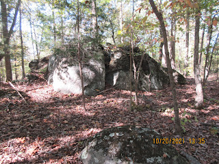
After a morning work day at Caraway Creek Preserve, we made a quick inspection of this nearby property. Due to its proximity to Ridges Mountain, you would naturally look for large boulders. We did see many but mere babies compared to Ridges.  

Randolph County bridge design

An old road bed sports this uniquely construction bridge, or what is left of it. 


Snakewort on rock in creek


Sunday, November 7, 2021

Oct 16 A Wedding in the Forest


It's the final night of the Three Rivers Land Trust's Uwharrie Thru Hike. Hikers are welcomed to the group campsite near the Walker Creek Trailhead. It's threatening rain and quite windy but everyone is in high spirits for a special occasion. How many times do you get to attend a wedding in the forest? 


On the 2017 Thru Hike, Krista and Marcus first met. On this Thru Hike they will wed. Planning weddings are always challenging but having one outside without electricity, no running water and no plan B in case it rains, that's tricky.  


Yet, it was perfect. Take a look at the coolest wedding I've ever attended:


Beautiful tabletop arrangements of sunflowers. Marcus and Krista often pick roadside arrangements of Black-eyed Susans, Tickseed and Woodland Sunflowers. Burlap tablecloths and camp lanterns fill out the arrangements. Hikers are thrilled to see actual seats after 3 days of sitting on rocks and logs.


Catering a wedding in the forest looks like this. The big grills come on wheels. Propane heats the food. Boneless chicken breasts, corn, baked beans, pintos and collards was the menu. Oh, and cupcakes too. Joy had her gourmet s'more buffet set up as usual.

Working the grill


Krista's brother tended bar from the truck of his car. Red wine, white wine, sangria, rum, vodka, tequila, bourbon and simple mixes. What no Scotch! Beer from Four Saints was flowing as well.

She's on her way!


Guests were called to the wedding by Dave and his conch shell horn. Krista is escorted by the bartender. It's windy.


The setting is the upper field at Walker Creek Trailhead. It has a gorgeous view looking northwest. Officiated by Kim, Krista's sister. She first had to clear all the hurtles of becoming ordained. I think all you need is an internet connection and and few clicks to become ordained. During the ceremony, the wind blew and a vulture soared in the background. The bride is stunning in her butterfly dress. The groom sports a butterfly shirt and ball cap. Guests are dressed like hikers, beer in hand. 


Hikers form a hiking pole arch for the couple.

Here's Dave with conch shell, ready to call things to order.

Guests headed up the hill after the ceremony. A buffet style meal followed. After dinner, Travis Morehead of TRLT spoke about the property and TRLT. David Craft had some presentations. A live auction followed with Karen, once again, coaxing bidders to dig deeper. Katherine displayed her fire building skills. Things wound down for a pleasant social evening as darkness overtook camp.


After dinner speaker David presents Crystal with an appreciation award.


I'm enjoying a beer.


Apr 20 Waterwall on Walker Creek

  Waterwalls redirect floodwater back into the creekbed. There is one very near the Uwharrie Trail on the Walker Creek section. This one is ...