Tuesday, June 25, 2019

Jun 25 Uwharrie Chanterelles Make 2019 Debut


Recent rains provided the magic needed to make chanterelles appear once again on the Uwharrie forest floor. For two straight days I subjected myself to drenching humidity, a constant contact with spiderwebs and all the other discomforts a hot Uwharrie summer brings. My reward was 6.2 lbs of Golden Chanterelles and the solitude of the forest. I should also mention the Wood Thrushes put on a wonderful concert for me.


I picked in the usual spots and realized we had an unusual crop to start of the year. So, I ventured into some unusual spots and was rewarded well. I think the window will close quickly as there is no rain forecast anytime this week. Those mushrooms that are just starting out, are looking for moisture and they won't be able to get much. It is a conundrum. The best chanterelles are those that have dried out a bit. However, those conditions mean no new ones form and retard the growth of any small ones. So the world of chanterelles hinges on moisture, a precious commodity in a NC summer.


Woodcrafting is an unwelcome practice in the National Forest. These are live trees that have been cut to craft into forest furniture. It makes for great TV for couch potatoes but detracts from our forests.

Friday, June 7, 2019

Jun 5 Appalachian Trail - Whitetop Mountain


Another shuttle hike on the Appalachian Trail, picking up where we left off yesterday. Russ and I start hiking under gray clouds at Elk Garden, early. We are hoping to beat the expected rain. The forecast looks like we should be able to do that and I am hoping that is the case. With no rain gear other than an umbrella, I am unprepared, as usual. 

The AT parallels the road for about a half mile, gradually heading uphill. We never seem to hike up steeply. It is a gentle upward pull until we pop out into the open meadows of Whitetop Mountain after about 2.5 miles.   


The Flame Azalea is really putting on a show for us. There is more Flame Azalea here than I have seen anywhere else. More than Andrew Bald even. Gregory Bald is still the king of Azalea but it is not all Flame Azalea. 


Orange is the theme through here. Bush after bush. Its exciting.


Disappearing into the woods and then re-emerging, the Azalea is gone but we can see the iconic Buzzard Rock ahead.

Buzzard Rock on the horizon

Atop Buzzard Rock we stop to speak with a fellow from Albuquerque. He does not have a trail name but Russ, later, decided to call him Lucky. Attempting to through hike last year, he called it quits somewhere in Tennessee after 2 weeks of rain. There was also a story about taking a Greyhound bus to save money. The bus had a mishap which caused the cargo area to not be accessible. Another bus carted the passengers on but his pack got lost in the shuffle. Staying in a motel for a few days, he decided to rent a car and drive home. By the time he reached Knoxville, Greyhound called and said his pack was found. So he was back on the trail. 

Another fellow there at Buzzard Rock declined to converse with us. He had the AT insignia tattooed on his leg and was carrying a ukulele.   


Somewhere between here and the next road crossing, it began to rain. In the forest, we were protected from it for the most part. We reached Beech Mountain Rd where I have parked and hiked from in the past. Today, we parked in the tiny pulloff on Rt 58 another mile along the trail. 


In that mile we walked through a dark Rhododendron tunnel, along what appeared to be a railbed and through a wonderful White pine forest. My car was waiting for us. And just in time, the sky opened up. By the time we reached Russ's car back at Elk Garden, it was pouring. The minivan parked right next to Russ's car, had its sliding door fully open. Someone had hiked off, forgetting to close it. That would not be a pleasant sight if you were returning to the trailhead in a drenching rain. 

Jun 4 Appalachian Trail - Grayson Highlands to Elk Garden

Laurel buds

A shuttle hike from Massie Gap to Elk Garden is the agenda for today. I'm collaborating with fellow AT section hiking buddy, Russ. We have established a short term goal of completing the AT from the Nolichucky River to Grayson Highlands (160 miles). Well on our way to doing that, we have a few gaps to complete still.

Nap time

From the parking area to the AT, it is a short, well worn trail, traversed by more hikers that I can imagine. Grayson Highlands is a spectacular place with wide open views, ponies, Rhododendron, blueberries, blackberries, strawberries ... Who wouldn't like it. A great place for families to get kids acquainted with nature.

Oh, that foal is just taking a nap. Its exciting being a baby!

Meal time

We stopped for a few minutes to watch the ponies. There were several foals really enjoying being foals.

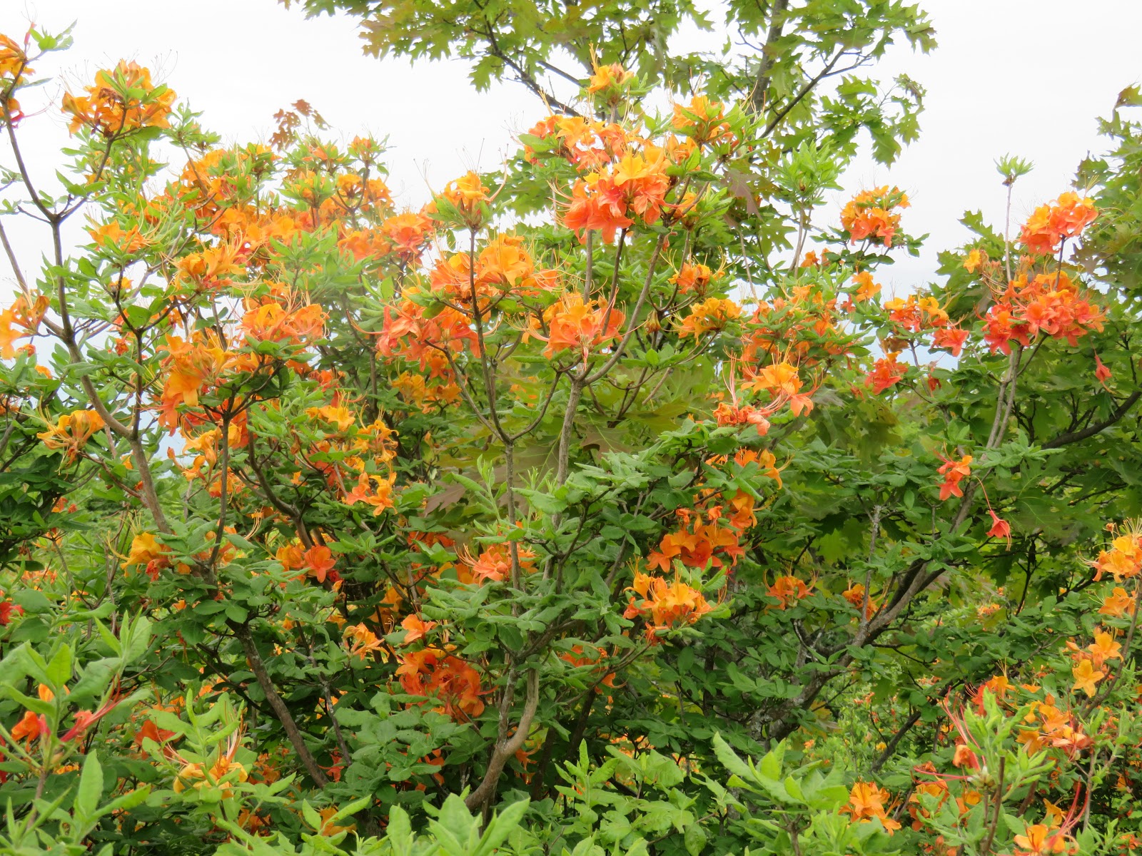
Then it was off to see the Rhododendron. We stayed on the AT, although there are so many options here - Wilburn Ridge, Crest Trail, Pine Mountain Trail and horse trails. Views in all directions are fabulous. I think I spot Snake, Beech, Sugar and Grandfather but who knows, I might be completely off.

A couple of gals asked us for directions. Actually, one gal asked for directions, the other, a German woman, was hellbent on continuing until they ran into a horse trail. I gave my map to them but our advice to head back to Massie Gap on the AT was falling on deaf (German) ears. I wish they were carrying some water since it was a haul back to the gap at this point and, clearly, they were at odds on what to do. 


After traveling through a rocky cavelike area, reminiscent of the rock jumble on Grandfather, we reach the gap and are surrounded by Catawba Rhododendron. Coincidentally, this spot is exactly 500 miles from the start of the AT at Springer Mountain, Georgia. 


For AT hikers, this is a worthy milestone, or stones, in this case.


Hiking on, we travel through unmatched scenery. Soon, the unassuming summit of Mt Rogers fills our view. We reach a shelter and myriad overflow campsites, where we pause for a lunch break. Then it is on toward Elk Garden. We meet and talk with several NOBO hikers including Bear and Lambo from Austin TX, Tabasco from Massachusetts and Marble, or was it Marvel? One other guy asked if "Vegas" was ahead. I don't know if Vegas was a trailname or Las Vegas. We must have missed the casino back at Rhododendron Gap. 


Not long after passing the spur trail to the Mt Rogers summit, we exited the meadows and entered the woods. A cool breeze blew our way, making it a very pleasant afternoon.  


The very final descent to Elk Garden is back in open meadow. As we walked through it, we noted vehicle tracks. It appears a vehicle had zig zagged up or down the hill dozens of times. Wondering if this might be a joy rider, I kept thinking there was a fence and gate at the road. Sure enough, there was a fence and gate. Upon closer examination, the gate had 3 links of chain with 3 locks. One of which was rusted open. Looking back at the grassy hillside with tire tracks all over it, I do think this was an interloping joy rider. Fortunately, outside of the tracks, it appears little damage was done. A similar joy riding horde, tore up Max Patch in 2012. Those vandals tore down entrance barriers and drove 4 wheelers all over the bald. Fifty volunteers put in hundreds of hours of time to replant, repair erosion and cover up the damage. Ten persons were arrested and one was sentenced to 90 days in jail.

A pleasant way to end the day

Jun 3 AT at Fox Creek


My Appalachian Trail hike for today is a rather short 6 mile in and out, beginning at the Fox Creek Trailhead. This is the first road crossed by the AT northbound after Grayson Highlands State Park.

I expected I'd see some NOBO hikers today and I did. There were some SOBO hikers as well. I also ran into a group of fellows hiking from Massie Gap which would make it about a 10 mile day hike. They were carrying pepper spray and had bells!


My entire hike is within the Lewis Fork Wilderness. It was a lovely hike with much green vegetation but pretty much devoid of any flowering plants. Roots and rocks were in abundance. The AT crossed a horse trail several times. The only shelter on this section, Old Orchard Shelter, is located right at one of those intersections. So, hikers and equestrians, both camped there. I saw one horse in residence but not its rider. Metal "bear boxes" now appear at many shelters as a way to mitigate the issues with shelter bears. One shelter near Watoga Lake was abandoned and eventually burned because it had become such a hangout for bears. The bear boxes seem like such a better solution. Controlling bear behavior by controlling human behavior is pretty tricky.


At the edge of the wilderness and through a gate, the Highland ponies manicure the green meadows. It is so lush here. Their bellies look like they will burst from the feasting diet. At this point, I turn around, go back through the gate and head downhill, retracing my way back.


Jun 1 Trailblazers on Mt Shepherd


National Trails Day is celebrated by every hiking and outdoor club across the country. The Uwharrie Trailblazers were no exception. We had planned a short hike and cookout. Agonized over the menu and strategized  over how to get dozens of hikers up the observation tower at Mt Shepherd. E-mails and messaging networks were used to capacity. And then the reality set in; no one wanted to attend. Well, there were 2 or 3 interested souls. Cookout was changed to pizza at a brewery and our small band of adventurers started up the mountain.  


It was a relatively clear day, affording long range views. Hanging Rock, Sauratown Mtn and Pilot Mtn made appearances. While in the top cabin, I heard a buzzing noise and then suddenly, from nowhere below, a drone buzzes by me. Keena had secretly stashed his drone in his pack, waiting for the right moment to unleash it upon us. 


On the way down, we ran into a group of scouts working on an eagle project, clearing a trail through a clearcut. That is hard work. It was a small group but great fun and the afterparty rocked.

Monday, June 3, 2019

May 30 Greenbrier River Trail - Marlinton to Renick


Bicycling on the Greenbrier River Trail always means I will see plenty of deer. I watched this fellow walk across the river. The shallow water is no deterrent at all.  


Yesterday, the afternoon was punctuated with a series of thunderstorms producing strong winds and lots of noise. Fresh treefalls were in store for me today. This is the first of 4 I had to wrestle my bicycle through. It was early in the morning and I got soaked in the wet leaves. 


The Watoga Bridge crosses the river for the final time on the way to Lewisburg. After crossing, there is a dirt road alongside for a mile or more into Seebert. There are many cottages dotting the way. I spotted a couple which looked like year round residences. Their vegetable gardens were like works of art. Perfectly staked tomato plants were alongside perfectly aligned pole beans.

If you are passing through here, there is a store, Jack Horner's Corner in Seebert. Ice Cream and microwaveable processed grub is available. 

The hanging garden of Watoga

Today's ride is a bit longer than my ride to Cass. I pass through many farms or former farms, fishing cabins and old homes. You even pass a prison with plenty of fences and concertina wire. 

About mid morning I stopped at a campsite for a break. Two fellows were just about to take off with bicycles laden with gear and bicycle trailers. We spoke for about 10 minutes. These guys were rail trail riders like me. We traded stories about the trails we had traveled. We had another thing in common, the Greenbrier was our favorite.


The Droop Mountain tunnel needed to be supported on this end. The other end is just rock cut. 

While visiting Green Bank a couple days earlier, I learned one of the radio telescopes on their property was shipped via railroad and had to travel what is now the Greenbrier River Trail. There was 3 inches of clearance in this tunnel. I guess they knew that ahead of time but I bet the train slowed down just the same. 

When I arrived in Renick, I was pretty wet and dirty having had four tussles with downed trees. So it felt great to get in some dry clothes.

May 29 A Walk in the Cranberry Glades


It is always a special treat to walk through this botanical area. The entire bog area weighs in at 750 acres. A boreal bog with a base of peat, as deep as 10 feet makes this a special place. Several mountain streams flow and seep through here before continuing the journey to the Gauley River. At an elevation of 3400 feet, the bog supports plants more common in Canada than anywhere close to here. It is the southernmost range of several.


A half mile boardwalk leads through just a corner of this huge bog. 


Cinnamon Fern looks like it rising out of Skunk Cabbage.  


Up close it does not appear cinnamonlike at all. 


Here is one of the star attractions, Purple pitcher plant. There are quite a few here if you know what to look for. Despite the purple flower, this plant is rather inconspicuous and hard to spot. Unlucky insects manage to spot it. In the photo below, you can see the insect death chamber. Insects drown in rain water which collects in the tubes. Prey capture is quite inefficient with some studies showing it to capture only 1% of visiting insects. 


This guy sneaks across the boardwalk


The extremely tiny Sundew plant is very hard to spot.


Rounding out the boardwalk tour, a wetland pool is home to lots of frogs. A family of ducks made this home as well.

May 29 Greenbrier River Trail - Marlinton to Cass


I saw two Snapping turtles on today's ride. This one was parked in the road before I arrived at the trail.


The town of Marlinton sports a colorful depot. Several years ago, it burned and now has been rebuilt.


The station also has a water tower with filler. There are other opportunities for (boiler) water along the trail. Usually they are creeks the train tracks cross over. These spots are signed with milepostlike concrete signs with a "W".


Leaving Marlinton headed north to Cass, the river is on my left for half the distance. At the horseshoe bend, the trail crosses the river. 

Riding along here a Black bear, completely hidden in the tall vegetation, darted across the trail just 10 feet in front of me. Who was startled more? I can't say.


Goat beard was blooming in spots all the way to Cass.


I don't have photos of the horseshoe bend bridge and tunnel since I made a video of it, thinking it would be far better than photos. However, one should have realized the video was too big, in databyte units, to upload to my blog. And I just don't have the time and know how to put it somewhere else and link it. So, accept this; it is cool. Dark inside too. Looking on a map, the river actually does a big S turn, so it is a double inverted horseshoe bend. Of course, I knew I'd be bicycling through it and, of course, I forgot to bring a light.

Mileposts come in handy


This little community of Clover Lick has this cutest little depot, all restored like new. Clover Lick is way to small to have a post office. There are about a dozen homes here. There is also a bridge across the river. Although, if you sat here for an hour, you might not see a car.


One thing that was in abundance today - flowers. The most showy and numerous of all - Multiflora Rose. Look up "National Invasive Species Information Center". You'll probably see a photo of one. After declaring a temporary moratorium on despising MFR, I enjoyed seeing so many in bloom. And was glad they were here and not in my yard. Nothing will tear you up more that MFR.


The whole town of Cass is a WV State Park. How did that happen? It is a tiny town of just company houses, all painted white. The Cass Railroad is also incorporated into the State Park. A steam engine pulls a few passenger cars of tourist up the mountain on an old logging railroad. The engine might actually attain 10 mph in spots. Maybe not.

As the trail reaches the end, you pass a graveyard of old railroad cars, engines and equipment. The rusting hulks are being swallowed by vegetation. 

It was a fabulous ride. 

Apr 20 Waterwall on Walker Creek

  Waterwalls redirect floodwater back into the creekbed. There is one very near the Uwharrie Trail on the Walker Creek section. This one is ...