Monday, February 22, 2016

Feb 7 Sisters of Hanging Rock

Keyhole Rock
photo credit: Matt Perry

Today's hike is a shuttle, beginning near the Danbury water tower heading up to Sheep Rock and continuing to the Hanging Rock and the park's visitor center. We are a group of 13 from the Friends of Sauratown Mountains group. Except for the last mile, the hike is entirely on unmaintained trails or off trail. 

Our first task is to gain enough elevation to attain the top of the ridge I call Hanging Rock Ridge. I consider the ridge to include Hanging Rock itself, the three Sisters and Sheep Rock. 

Once we have attained the ridge and regrouped, our first stop is a rock ledge which provides a view of Keyhole Rock. You can scramble down to this keyhole but we have a long hike over undulating terrain today, so we stay on the top. 


We stay on the top of the ridge as we make the long climb up Little Sister. I don't know the official names of these peaks. They are called the sisters. I have heard them called, First, Second and Third Sister. They are referenced in a newspaper article as Saura, Cheraw and Catawba which follows the plight of the Saura Indians which last occupied this area. Their group having been reduced in size, moved south to assimilate with others and be called the Cheraw. Shortly thereafter they moved west to do the same with the Catawba Indians. Nevertheless, I call the 3 peaks Little, Middle and Big Sister. 


Our group splits apart on the long climb up Little Sister, so I ask Matt to take the lead group to the gap beyond Big Sister and visit the site of the plane wreck. My group slowly makes the climbs and descents of the Sisters. We are treated to views like the one above as we walk along the tops of the peaks.

Our arrival at the rendezvous spot is about 10 minutes before Matt's group arrives after visiting the plane wreck. 

Once again the group splits on the climb up Hanging Rock Ridge. I never see the lead group again but receive a text saying they all made it back. Our group explores the cantilevered rock with the stealth campsite. This is always an amazing geological formation to visit.   


Hikers slip through a hole in the rocks before leaving Hanging Rock Ridge.

Jan 31 Sugarland Rockhouse

Porcelain from a sink or toilet 

I am leading a small group of 3 on a beautiful Sunday morning to the Sugarlands rockhouse. Along the way, we pass the ruins of CCC camp #1458 and an old cemetery. At the CCC camp we briefly look around the ruins of the officers' quarters. This building sports two large chimneys. You can also see the piping in the ground for the latrine which appears to have been either part of the building or adjacent to it.

One end of the officers' quarters

Both chimneys had dual fireplaces but with one bricked up on each chimney. It appears this was done to accommodate a stove.

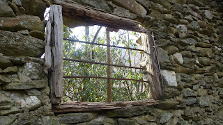
Rockhouse window

Finding the rockhouse is pretty simple now. You just need minimal directions, as there is a well worn path to it. The creek just before the hill where the building is perched, had a lot of water in it today but was crossed via a rock hop. Once at the building, I am always amazed to see it still standing. Walking alongside a bowed wall or through a dilapidated door frame, quickens your pace. Someone has taken one of the bed frames and used it to prop a door jamb. 

Rockhouse main room

My two hobbies merge

There is a fair amount of artifacts laying about the cabin. The biggest pieces are bed frames and window bars. These are my favorites, a couple Krueger Cream Ale quart conetops. These cans would have been produced in the late 1930s and suggest the structure was used recreationally. When I first came out here, you could see the color in the cans but they have since oxidized beyond recognition. 

Crack above window

I think that is Sugarland Mountain in the background, as viewed through one of the windows. Note the separation above. Someday, I will visit a pile of rocks here.

Jan 29 Albright Grove

Baxter Cabin

Beginning on the Maddron Bald Trail, our mall group of SEFTC hikers, followed the old road which leads to Albright Grove. The first stop is at Baxter Cabin, a one room structure without a window. Some of it has been renovated but the sides of chestnut logs remain original. The road we turned onto from Rt 321 was Baxter Road. So, obviously this is a family name of the area.

The road continues to a spot where it loops at a turn around. This was the long ago trailhead. From this point, the trail is more of an old wagon road until we reach the footbridge below.


At this point, the trail crosses Indian Camp Creek and then hugs the hillside as it rises quickly. There is much Fraser Sedge in this area. Within a few hundred feet, we arrive at the first junction with Albright Loop Trail. As we make our way around the loop, large trees make their presence felt. Some of the massive Hemlocks in the grove have been saved but looking outside the loop's boundary, they are all dead. Some have fallen in spots, rerouting the trail. The other really big trees here are the Tuliptrees. I am also impressed with large Silverbells. Some trees have large hollow bases but still survive. The grove lacks the magical feeling I first experienced before the Hemlocks started to succumb to the Hemlock adelgid.  


Back on the Maddron Bald Trail, we passed this massive log. Given the time, I would have liked to count the rings, but that was not to happen today.


Above is a great example of a nurse log or in this case, a nurse stump. Trees with very slow decay rates, like American Chestnut, supported seedlings which grew into trees until finally the log or stump fully decayed leaving an odd looking trees supported with a tangle roots.

Mar 26 Check Dam on Taylor Creek

  Another dam in the Caraway Creek drainage is one that many people have seen as it is visible from Lassiter Mill Rd. The owners on creek ri...