Thursday, December 16, 2010

Dec 7 Angels Landing


View the angels have

The trail to Angel's Landing starts innocently enough, a mostly paves path switchbacking its way up the canyon wall. The trail briefly follows a slot canyon before heading up a series of very steep, stone lined switchbacks. I can't believe someone actually built this trail. There is a resting spot at Scout's Landing.

No angels here

I looked out at the wall in front of me and wondered where the trail went. Surely it did not go up that tower with no discernible route. Where else could it go?

Yes, that is the way

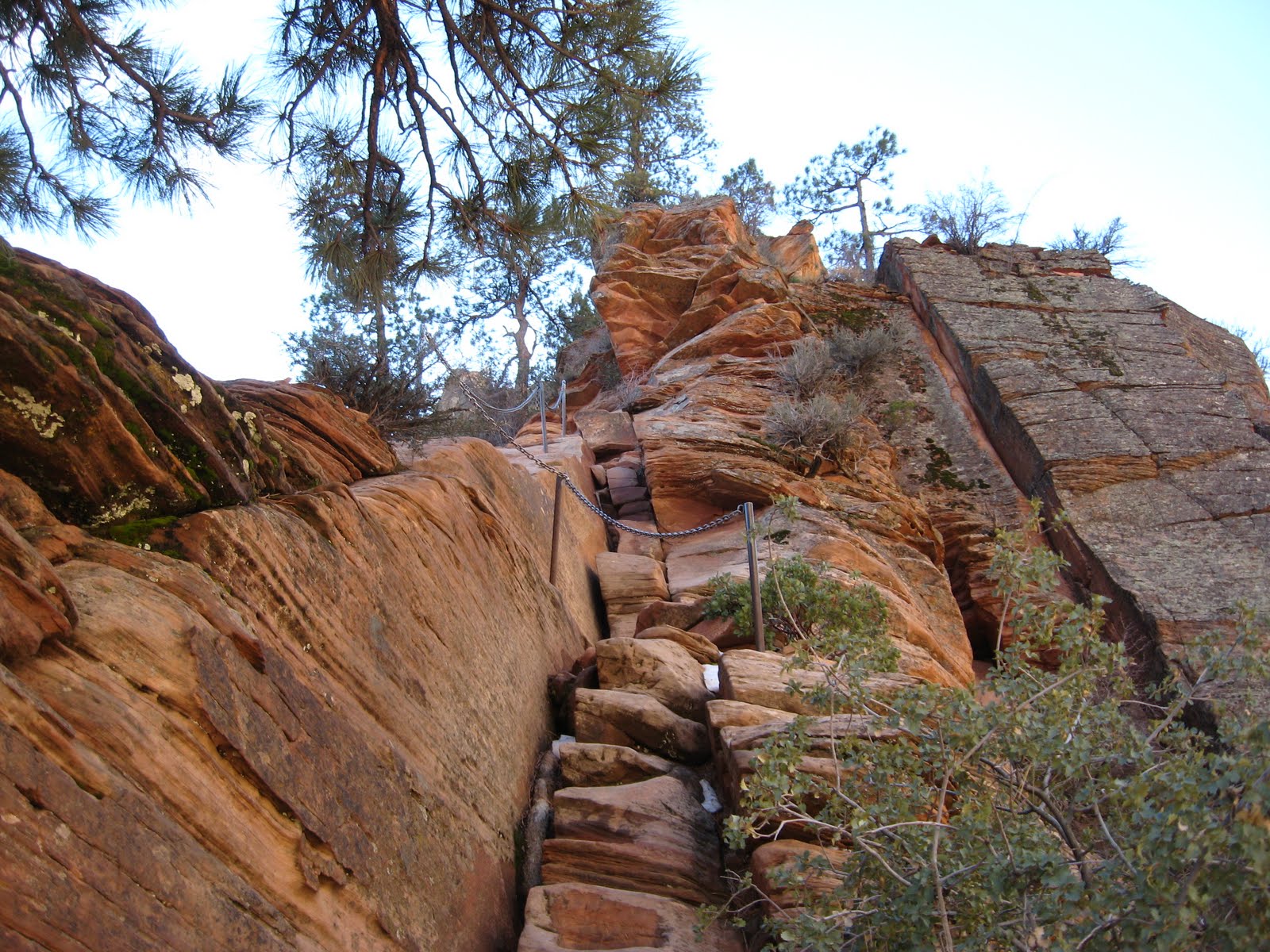
The best way to find out where the trail goes, is to follow it. I knew it couldn't go up that tower. The closer I got the more convinced I was, no way. As you have guessed, that is where it went. Poles with a chain slung between them offered all the comfort you'd get on this trail. I passed a German couple making their way down. they had been the first of the day up and declared it would be all mine. I pushed on. The path narrowed to a couple feet wide with drop offs on both sides, straight down, thousands of feet.

I ran into an icy patch in a very precarious spot. Twice I failed to make it over the ice. I sat down on the rock and tried to decide what to do. Turn back? I looked back and there at Scout's Landing was the German couple staring up at me. How could I turn back now with this international reputation on the line. I managed to get over the ice and on to the top. For the 45 to 60 minutes I was up there, 5 others managed to make it to the top. The view is one of the best in America. Not only are you looking down canyon but also up canyon. Angel's landing is stuck out in the middle of the canyon rather than a side wall.

Big drop on both sides


Dec 7 Virgin River narrows


The Virgin River is responsible for cutting Zion Canyon in Utah. If you follow the river upriver through the gorge it appears the canyon ends in a dead end.


This obviously is not the case, the river continues but the canyon narrows to a little as 20 feet in places. Remember, the sheer rock wall continue to be over a thousand feet vertically.


Narrow canyons like this pose tremendous threats to those who wade up the "slot" canyons. Any rain can raise water levels. Folks have been caught in these situations and perished. There was simply no where to go, no high ground, no outrunning the water, no surviving in the water as it rushes downriver.


I spoke with a local outfitter who rents equipment for walking upriver. This time of year it includes dry suits and waterproof footwear. They provide shuttle service to point upriver so you may walk in the river to the end of the Zion Canyon Road. That walk is about 10-12 hours and not available this time of year anyway due to closed roads.

Dec 2 Moore's Wall Scramble

Looks like an Indian Face

We started our scramble at the climbers parking area west of Hanging Rock State Park. It is barely a 15 minute walk from here to the wall. The imposing wall presents no easy routes up. Without the technical skills or equipment, we had to walk along the base looking for a scramble route up. Probably 300 yards from our starting point we found such a place and managed to hit the Moore's Knob Loop trail at the top. We had to cut through many briers on the way up. It was barely a 20 minute walk to the tower. We visited Balanced Rock before heading down the trail.


This is a spire near Indian Face

We made our way out to the top of Indian Face through a brutal mess of briers and laurel. It does not appear many folks venture out to this spectacular outcrop. Views were worthy of a lunch break.

Angry Ben surveys the earth below

After our break, we headed down a wide gully beside Indian Face. Immediately, we were stunned by the sheer size of the wall and the formations we saw every few steps. Climbers have worn paths along the wall and the hiking was almost an easy stroll. Spires, caves, rock overhangs etc proliferate here.


A spire creates a narrow passage

We made it full circle, back to our starting point and the climbers access trail back to the parking lot.

Monday, November 29, 2010

Nov 2010 Deer Carcass attracts


Here is what shows up when you have a dead deer lying in the woods. This 8 point buck was shot during black powder season and limped off to expire alongside my hiking trail. I decided to put my trail camera up for a couple weeks to see what happens by. In just 2 weeks I had 418 photos triggered by a motion detector. These are the highlights.


Monday, November 8, 2010

Nov 7 American Tobacco Trail


The American Tobacco trail, now open on its southern end, for 13.6 miles, makes for a lovely afternoon ride. On this beautiful Sunday afternoon, 12 Piedmont Hiking and Outing Club members rode the 27 miles at a strong pace.


The northern part of this trail begins at the Durham Bulls stadium and continues south to the break at I-40. You see alot of backyards on this section.


Here we are rolling along the ATT.


Friday, November 5, 2010

Tom Leo's Sign Collection


The lighting was terrible so I was only able to get little more than half the collection pictured here.


Tommy was a wonderful host. I spent 2 days looking over his vast collection. In addition to signs he has a nice crown collection


Biking the Allegheny River Trail


The Allegheny River and the Samuel Justus Trails will someday follow the Allegheny River from Titusville to Pittsburgh. Right now there is a 34 mile unbroken stretch from Oil City to Emlenton. Add a few road miles and you can access anothre dozen miles of trail. The really amazing part is - it is paved. I rode the 28 miles from Franklin to Emlenton in about 3 hours. The ride back was even easier with the wind at my back.


Just 5 miles from Franklin, the Sandy Creek Trail, also paved, crosses the Allegheny on this trestle. Another few miles downriver of the trestle is Indian God Rock, a large sandstone rock riverside the Indians considered sacred. There are pictographs and much historical writing on all sides of this rock. I suspect that the Indians thought highly of it because their carvings facing north, filled with moss and made a wonderfully colorful display.


The railroad was built shortly after the oil boom. The Drake Well in Titusville was the first successful oil well in the world. Local farmland was traded like stock options with everyone wanting a piece of the riches. Even famous assassin, John Wilkes Booth got into the action. Soon there were refineries up and down the river, refining the crude into lubricants, illuminants, waxes and polluting the river into a smelly cesspool. Famous Quaker State got its start in Emlenton, the site now off limits due to contamination. North of Franklin, Wolf Head oil was refined. Remnants of other refineries can be seen along the river as well.


The railroad was sold in 1914 to Pennsylvania RR. Immediately 14 miles of track was eliminated by the construction of 3 tunnels costing $1.5 million. The longest is 3350 feet and quite dark. I used 2 flashlights and had to walk as I could barely see the reflectors on the pavement.


Friday, October 22, 2010

Oct 16 2010 Rock Castle Gorge


The meadows were in motion with a strong wind blowing from the west. It was difficult to walk at times in these conditions.


One more beautiful day in the mountains.


Oct 9 2010 McAfee Knob


One of my favorite walks is up to this view of the Roanoke Valley. Part of the trail is on the AT, complete with a popular shelter/camping area and great views.


Another stunning day in the mountains.


The Roanoke airport and the city itself can be seen here,


Oct 7 2010 White Top Hike


Today, we scouted this hike along the AT hoping to add it to our schedule soon.


It was a short but steep hike to the open side of Whitetop. We did not attempt to climb to actual top, as it was getting late and it appeared the towers on top detracted from it's appearance.


This was a great seat for lunch. A bit on the windy side though.


Hang onto that hat.

Oct 2 2010 Pinnacle Hike


Here we are gathered for another hike up heartbreak Ridge to the top of Pinnacle. It is a lovely autumn day without a cloud.


The Old Toll Road we hike on for short distance, was open to vehicles this Saturday. It is the only day of the year the road is open. Traffic, consisting of 4 wheel drive cars and trucks, travel in one direction along the road. Originally the road was the only option to get to Mt Mitchell.


Lunch is on the rocks of Pinnacle. Views are just spectacular here. Every seat was the best seat in the house.


This is the view toward Mt Mitchell. The Blue Ridge Parkway meanders nearby too.


Sept 30 2010 Moore's Knob Loop

Finally, after a couple months of relative inactivity, I'm back on the trail albeit a step or two slower. I wanted to get in a good workout prior to this weekend's Pinnacle hike and to break in a new pair of boots. So far I love my Zamberlins.
I think these nasty creatures are earwigs. They were all over the observation tower on Moore's Knob. None landed on me but they were buzzing all around causing me to make a hasty retreat from the tower and knob.

The view from hanging Rock was quite nice today. All 3 of the triad cities were visible. There were a few ravens calling in the distance and a broadwing hawk overhead.


Apr 20 Waterwall on Walker Creek

  Waterwalls redirect floodwater back into the creekbed. There is one very near the Uwharrie Trail on the Walker Creek section. This one is ...