Tuesday, February 22, 2022

Feb 6 Three Sisters to Orrell Road


Five friends tackle the Three Sisters Ridge at Hanging Rock on a stunning Winter day. All of my Three Sisters treks have started at the Visitor Center parking area and headed up the asphalt walkway toward Hanging Rock. We are very pleased to hear that a new trail is being built to bypass this walkway and the steps - all of them. Park staff and FSM volunteers have already made some progress on this trail. AND have cleared much of Sheeprock Road coming from the other direction. 

First stop along the way is the cantilevered rock, or balanced rock as some prefer. The graffiti here has been partially removed.  


Following the wall to the cave is considerably easier now that this place has been discovered and a pathway clipped through the briars. Continuing along the wall, I had previously climbed up it but if you just continue it is a much easier ascent and you get to see this cool anvil rock from below. 


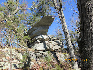
Someone took my photo while on the anvil. I wish I had that shot to post here.


Is it "Big Sister" or "First Sister". We don't know. I use both terms. There was that newspaper clipping that named them Saura, Cheraw and Catawba following the plight of the Saura from one tribe to the next. I assume the big sister is Saura and the next two follow as that was the sequence going from being their own group, the Saura and then assimilating with the next two as their numbers dwindled. 


After crossing the sisters, the views to the south open up and rock ledges line the ridge. 


Lunch was here at the keyhole overlooking Flat Shoals Mountain and much of the recent additions to the park.


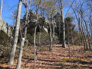
Instead of dropping down Sheeprock as had been my route through here, we descended on the newly cleared Sheeprock Road and made a big swing to get on the south side of the ridge. Actually, this was all done on an old road which led to Stegosaurus Rock, above.


We followed the road all the way to a falling down tobacco barn near the fields along Mill Creek. 


I had intended to follow an old road to the fields at the end of Orrell Road, but I navigated us off that track and we ended up walking this way and that until we ended up in the fields. Along the way, we got to see the bottom side of all the dumps along Orrell Road. Tires go downhill easily.


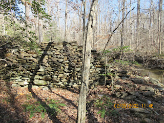
Here is Hikes End at this beautifully crafted chimney.


Monday, February 7, 2022

Feb 5 In the Uwharries - Plantation Road


I'm channeling Joe Moffitt today. His book An Afternoon Hike into the Past is my guide. 

We call it Plantation Road but Joe says it was known as the Byway or more formally the Salisbury-Fayetteville trail. It would have gone through Strieby along the way and right past the home of Christopher "Kit" Bingham on what was then called Grassy Ridge. Joe placed an aluminum sign at the site of the house. There are 2 piles of rocks there which were, likely, the two chimneys. The family cemetery with 35-40 graves lies about 200 yards from the site. Kit is buried there (date of death 1869 at age 103 or 104) as is his wife Dolly and grandson Rudsell Bingham.

Island in the river looks to be manmade

After checking around the homesite, I walked along the old road until it crosses Hannah's Creek where Kit had a corn and grain mill according to Joe. This puzzles me since this dam appears to be a detention dam not a regular dam which would have impounded water for a pond. Perhaps the dam's center had been washed away. That would have been a powerful event to cause stone to wash away.


It is a sizeable structure. Both the photo above and photo below are both sides of the dam. From the upriver side, you barely can tell there is a dam.


On this trip, I did not cross the creek here but did see a large flat area on the other side which may hold some more clues as to what went on here long ago.


Just upriver from the dam, the river divides and creates an island. This appears manmade to me and if it is, why would someone create a second river channel if there is a dam impounding water here?

To add more intrigue, on the nearby hillside are a number of small rectangular stones on the ground. it reminds me of a graveyard. I am not prepared to call it such as it is not level and periwinkle is missing but caught my eye.


Friday, February 4, 2022

Feb 3 Tanyard Creek


An odd building that sits behind the New Life Baptist Church is Reidsville. Allegedly, it is the only remnant of Charles Penn's Pennington estate. Its purpose is unknown. No windows, two doors.


Warming hut at a mill alongside Wolf Island Creek. Customers would have been able to wait in this stone structure while having their grain or corn ground. It had a fireplace inside which is about to crumble.


After those two preliminary stops we arrive at the main attraction, Tanyard Creek. Situated along the Dan River, this property includes Tanyard Creek and its unique geological formations. First, we had to check out the house above. In almost complete disrepair, we carefully made our way inside gingerly moving about. 


Not knowing what this is, I had to email a photo to my brother, the family entomologist. Vespa Crabro he responded. Otherwise know as European Hornets and loaded with formic acid I am told. 


We walked across a turnip field with the largest turnips I'd ever seen, interspersed with daikon. We viewed the mighty Dan for a few minutes. There was a bunch of rock in the river. We examined them to determine if they formed a Batteau structure. Not likely was our conclusion. 

Up Tanyard Creek we went. At first the conglomerate rock was not that noticeable nor impressive. I didn't take any photos. Shortly, that changed and the rocks began to stand out. They resemble mortar with stones and gravel mixed in. Some stones are river worn smooth and others are not. They are of many sizes too. I understand there are different types of conglomerate rock. Pebble, cobble and boulder constitute the main types, all based on size. This seemed to be primarily cobble but other sizes were present as well. We saw a large hole in a vertical rock. It was about the size of a laundry basket and claimed to be an Indian roasting oven. Maybe not.


Our route up the creek is blocked by a jumble of fallen trees. We manage to cross with only my left foot getting in the water. We maneuver up a very steep slope and find a level spot to walk. A few pieces of petrified wood lay on the ground. It was an easy walk to the top of a waterfall where we see large conglomerate rocks speckled with pretty river stones. 


After enjoying the rushing and falling water for a moment, we continue, seeing more petrified wood. Our route is hindered by uprooted trees and we are getting shredded by briars. 


The rest of the walk is intermittent briars. We find another place to cross the creek and perhaps a better route for the guided hike being held here this weekend. We debate the sanity of bringing a group here with its inherent risks. I'm glad I'm not making that call. 


Golden leaved Beech trees cover the sides on the gorge.


One last look at the lonely house atop the hill.


Jan 31 Sally Coggins Mine and Russell Cemetery


Using the Community Content feature on Alltrails, I learned the location of  the Sally Coggins Mine. As one might expect, it is in the vicinity of the Coggin Mine. Also, very nearby is the the Russell Mine. I planned to hike to the mine and used google maps to get me in the right area. That is when I noticed Russell Cemetery near the trailhead. It was easy to spot while driving there. The cemetery has been spruced up recently. A timber cut is ready to take place on the property and someone made certain to flag the cemetery so it would be avoided. Apparently, trees had grown up in the stone enclosure and were cut away. It looks like the gravestones have suffered some neglect too. 


After a quick cemetery visit, it is off to the trailhead, a gated road with a "Foot Travel Welcome" sign. The trailhead has been a dumping area for years and has become an eyesore. 

What on earth?


We followed the road for well over a mile until we could see no trespassing signs ahead. We devised an alternate route which took us up and over a mountain. The top of this mountain was littered with uprooted trees, probably from the June 2019 storm. We had to meander quite a bit to get through the tangled mess. Once we were on the top, we could glimpse a large cleared area nearby. 

Making our way down the steep slopes was painfully slow. We headed alongside a gulley and reached the bottom right at a major mining area. There were trenches, pits and lots of disturbed earth. We were looking for the horizontal shaft of Sally Coggins Mine. It eluded us. We followed a road to the cleared area we had seen. It was posted, so we did not cross it. Oddly there was an old cement truck abandoned here. 


I felt certain we had somehow missed the shaft back in the mine area, so back we went. We went right to the point the gulley leveled out. There was exposed rock here and a pool of water at the bottom. It was the only spot where a horizontal shaft could have been but it was not there. See photo below.


As you can see from this vantage point, there is a little bit of the rock wall that is not visible. I wanted to make sure that there was nothing there before we moved on. To do that, we had to scramble on steep and slippery slopes to get up above. 


There it is. I know it doesn't look like much but it matches the description I had. We tried to get down to it but the area was too steep. I could see that there might be a way to get down there but it would require a rope. So next trip, I'll remember that.

We bushwhacked back through a flat area to get on the road leading back to the trailhead. The mine is only a mile from the road but we managed to walk over 4 miles.


The oddity of the day is this poor critter wedged in the crook of a holly.


Thursday, February 3, 2022

Jan 27 Middle Prong Trail


Looking back at the bridge to the parking area, there has been some damaging wind lately.


A recent uprooted tree caused this rockslide onto the trail.


Large boulders are everywhere along here. This one has been propped up for some time.


The trail/road following Middle Prong features many delightful drops like this one.


We walked up the trail 2 miles and turned back, so we got to see everything twice.


Jan 27 Thunderhead Prong


Our destination was Middle Prong Trail but we got sidetracked. The Middle Prong Trail starts at the end of Tremont Road in the GSMNP. There is a mishmash of a parking area and immediately you walk across a substantial bridge. At the other side, the Middle Prong trail is a gravel road for several miles. As we crossed the bridge, one of those quiet walkway signs appeared and invited us to walk up the trail for however far we wanted. However, I noticed a side trail here and suspected that the gravel road was once passable by vehicles and thus, the quiet walkway sign was meant for the side trail. The first thing we noticed on the side trail was a sign directing you back to the Middle Prong trail. That didn't convince us, so we started up the side trail. It was along Thunderhead Prong.


Within minutes we came upon the coolest footbridge ever. A 2 foot wide I beam across the creek. I suspect it was a logging railroad bridge 100 years ago. 


We followed a very pleasant grade creekside. We had to scramble a bit here and there to get by tributaries. 


Despite being a "quiet walkway", it was anything but. Thunderhead Prong was thunderous.


We had lunch by a colony of Searsucker sedge. No reservations needed.


Eventually, we reached a spot at which a tributary stopped our advance. In better weather, we could have gone on but not on this cold day. 


We retraced back to the cool bridge and took our hike on Middle Prong as planned.


Apr 20 Waterwall on Walker Creek

  Waterwalls redirect floodwater back into the creekbed. There is one very near the Uwharrie Trail on the Walker Creek section. This one is ...