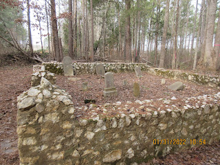
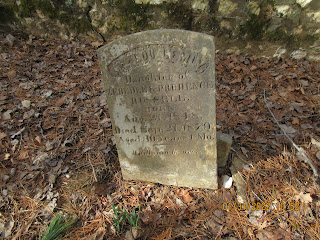
Using the Community Content feature on Alltrails, I learned the location of the Sally Coggins Mine. As one might expect, it is in the vicinity of the Coggin Mine. Also, very nearby is the the Russell Mine. I planned to hike to the mine and used google maps to get me in the right area. That is when I noticed Russell Cemetery near the trailhead. It was easy to spot while driving there. The cemetery has been spruced up recently. A timber cut is ready to take place on the property and someone made certain to flag the cemetery so it would be avoided. Apparently, trees had grown up in the stone enclosure and were cut away. It looks like the gravestones have suffered some neglect too.

After a quick cemetery visit, it is off to the trailhead, a gated road with a "Foot Travel Welcome" sign. The trailhead has been a dumping area for years and has become an eyesore.

What on earth?

We followed the road for well over a mile until we could see no trespassing signs ahead. We devised an alternate route which took us up and over a mountain. The top of this mountain was littered with uprooted trees, probably from the June 2019 storm. We had to meander quite a bit to get through the tangled mess. Once we were on the top, we could glimpse a large cleared area nearby.
Making our way down the steep slopes was painfully slow. We headed alongside a gulley and reached the bottom right at a major mining area. There were trenches, pits and lots of disturbed earth. We were looking for the horizontal shaft of Sally Coggins Mine. It eluded us. We followed a road to the cleared area we had seen. It was posted, so we did not cross it. Oddly there was an old cement truck abandoned here.

I felt certain we had somehow missed the shaft back in the mine area, so back we went. We went right to the point the gulley leveled out. There was exposed rock here and a pool of water at the bottom. It was the only spot where a horizontal shaft could have been but it was not there. See photo below.

As you can see from this vantage point, there is a little bit of the rock wall that is not visible. I wanted to make sure that there was nothing there before we moved on. To do that, we had to scramble on steep and slippery slopes to get up above.


There it is. I know it doesn't look like much but it matches the description I had. We tried to get down to it but the area was too steep. I could see that there might be a way to get down there but it would require a rope. So next trip, I'll remember that.
We bushwhacked back through a flat area to get on the road leading back to the trailhead. The mine is only a mile from the road but we managed to walk over 4 miles.

The oddity of the day is this poor critter wedged in the crook of a holly.


No comments:
Post a Comment