Wednesday, October 30, 2019

Oct 28 Lost in the Uwharries


Yes, even Uwharrie masters get lost. West Morris is a bit confusing to begin with, and I was not paying attention. Beginning at West Morris, my plan was to hike a 7.3 mile route described by Don Childrey in his Uwharrie Lakes Region Trail Guide, utilizing the Uwharrie Trail, Morris Mountain Rd and Panther Branch Rd. It looked nice on paper, simple, straight forward. So, when I saw the bridge over Spencer Creek (pictured above), I knew I had gone the wrong way on the Uwharrie Trail. How did that happen? I just wasn't paying attention at all those intersections back at West Morris. 


Rather than go back, I decide to proceed on, knowing that when I get to Rt 109, I can turn left and walk a quarter mile on the road to the Spencer Creek Rd. That is what I did. The gate across Spencer Creek Rd was open. I walked on a nice graveled road with sides recently bush-hogged. At a half mile, there is a parking area and the road is more of a dirt road with puddles. That lasted for about a half mile. At that point, trees were across the road and trees were growing in the road.  


There is a sizeable mining complex of pits here. Lots of pushed up dirt, littered with quartz. The road turns into a single track and fords a creek. On the other side, I reach the junction with Morris Mountain Rd, or trail as the sign below indicates. If I turn left, I'll be at Spencer Creek bridge in a matter of minutes. Not wanting my adventure to conclude so soon, I turn right to take Morris Mountain Rd to Barnes Creek Overlook Rd. That sounded easy and looked easy on the map.


All went well until I ran into posted property owned by Uncle Jim's Sportsmen Club. Not wishing to cross private property during deer season, I followed the boundary around the property thinking I'd see the other end of Morris Mountain Rd. It was a bit of a detour and then I found a road about where I thought I would. Following it, I seemed to be heading in a direction headed east and not north. So, when I reached an intersection, I turned left and eventually headed west. But wait, I'm on private property again. 


I worked my way in the direction I thought I should be going and ended up in the impact zone of this deer stand with door and sliding windows. It was on the top of a mountain so I tried to download a map. No dice. Neverthless, I starting tracking my route on geotracker. Even without a map, I wanted to see that I was going west and not circling back on myself. About a mile later, I found a timber road and followed it. Then I came to a 3 way junction. I'm completely at a loss which way to go. I turn right and end up a few minutes later on the UT and can make my way back to West Morris. Whew.


Sunday, October 27, 2019

Oct 25 Three Sisters Ridge to Orrell Road


One of my favorite off trail hikes involves Hanging Rock Ridge or Three Sisters Ridge as it is sometimes referred to. There is a well worn trail to the top of Hanging Rock. That is the start of our hike today. Our group of 5 hikes this trail almost to the top. We step off and head out the ridge. Wes reveals it is his first time off trail. The rest of us are in familiar territory. After the first rock is climbed, we find our way to the keyhole and then to the cantilevered rock which has a fire pit. I am dismayed to see graffiti on the rocks here. It is fresh and still has some gloss to it. There is quite a bit here. We clamor through the underbrush to the cave pictured above. This is a rather substantial cave with a huge vulture nest. 
  

From the north side of the ridge, we have a nice view of the Blue Ridge and beyond. The photo shows the view toward Moores Knob.

It is a long gradual walk down off Hanging Rock to the gap with the First Sister. The Sisters look big but they are easily climbed. We go up and down over all three. There is a significant gap between Middle and Third Sister making me wonder if we topped all 3 and I miscounted. Then we head down some more and try to locate Sheep Rock. I have GeoTracker on so we do not stray onto private property.


We think we are on Sheep Rock and settle down for a lunch break. From this point, I can make out the Mill Creek valley and watershed. I can't see Orrell Road but have a good idea where it is. It is our destination and we have a car staged there for the ride back to the Visitor Center. 


After lunch, we continue walking down the ridge in a easterly direction. I know we will run out of state park property if we continue this. So at the first good looking opportunity, we bear right and down more steeply. I sense that we are in the area where I've been before. It has that feel and after a few minutes we find an old timber road with a stone wall alongside. I know I have been there before. We follow it in the direction of Orrell Road. Eventually, it comes to an old tobacco barn which I recognize. 


From there it is just a matter of walking through a couple fields. Mill Creek is low and we decide to rock hop it. None of us make it without a splash in the water. I thought we were through with the creek but alas, we must cross it again. We all had another splash here. 

After piling in the car, we drove up Orrell Rd for a little tour of the new Hanging Rock property. 

Oct 23 Russell Mine


Its one of the shortest hikes you can take in the Uwharries but it is packed with cool stuff. You won't find this on any maps of the Uwharries. The Forest Service doesn't promote this place. They have had to bar off several mine shafts and put up an extensive metal barrier around much of the site.  


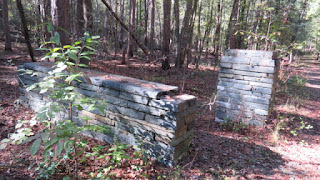
The shafts are cool (ha) but the real attraction for me is this massive stone structure which I am told was the Russell Mine Company. On this visit, it appears someone has been doing an arch survey. Perhaps the structure and roads leading to it are being surveyed to understand what went on here.


A rock outcrop here has been pretty thoroughly excavated. There are at least 3 shafts leading under it. They are all barred off now. Shinning a flashlight into them does not reveal much.


I took this photo from well above the shaft opening. It is in a steep gorge. 


This shaft has been barred off for years. It is the first thing you see after rock hopping across the creek. There is a old roadway passing right by it.


This one you can walk in. I took the photo from a collapsed portion. It would have originally been about 60 feet.

Saturday, October 26, 2019

Oct 21 Hanging Rock - Orrell Road


Beginning at Orrell Rd and heading along Mill Creek, then through some fields on an old road. At the first tobacco barn, head up on an old timber road until it peters out. At this point, look for anyway to head up. Deep drainage galleys make it difficult. It becomes really steep but I manage to pop out on top - probably between Middle and Little Sister.


Heading west on the ridge, I look for the first place to head down that is not a drop off. One presents itself and the way down is quite slow and deliberate. A couple of butt slides were needed. After 15 minutes, the terrain leveled out so you could walk without the constant fear of falling. 


I followed the first old road I encountered. It appeared to parallel Orrell Rd. So I ended up right back where I had started.


A walk up Orrell Road was in order at this point. There are a half dozen dilapidated buildings. It is not wise venturing in several since they look as if they could easily collapse. I suspect most will have to be demolished by the park before this area is added to the park map. 


There are sizable dumps here as well. Lots of rusting farm equipment mixed with old household rust - bedsprings, appliances etc. 


Must have been the farmhouse


Oct 20 Bioluminescent Mushrooms

Jack O'lantern mushrooms

 I see them a couple times a year, but always somewhere inaccessible at night. I never thought to pick them and bring some home. Nanci and I went out Sunday night and checked them out. There was not a hint of bioluminescent light. Disappointed, I grabbed a few and returned home with them. When it was completely dark, I could make out a faint white glow. This morning it is raining and the glow is much stronger. I can see them 40 feet away. It is only the underside (gills) that glow. When you look at the top side (cap), there is nothing. If I could photo them with a time lapse, I'm sure it would look eerie. 


Oct 19 Strieby Days


Off the beaten path. Off grid. Off highway vehicle. Off his rocker host. We are off to a cookout in the forest with our off the wall friends. The menu was David's rendition of Brunswick Stew. This Strieby Stew featured chicken and the standard mix of beans and corn. Cornbread was also on the menu. Probably a half dozen of folks' favorite cornbread recipes showed up, including one pan fried on the spot. I don't know if those pickled pigs feet got sampled. Everything else did. 


There was hiking, fishing, drinking and lots of good conversation and a definite relaxed atmosphere.


Stirring Brunswick Stew requires a modified J Stroke. Veg Stew was available too. 

Folks arrived in style


Oct 15 Morrow Mountain


Today's hike is a variation I've not done before. There are so many trails at Morrow Mountain, you can almost always do a loop of some sort. A great place to start is at the park office. From that point, I headed up Hattaway Mountain Trail. Dr Kron, who lived on the property in the early 1800s, called his place "Attaway Place". 

This mountain has a ryolite quarry on top, as do all the other mountains in the park. Somewhere up there, I went off trail to the left thinking there was an old road nearby. It was quite a bit further than I thought, but I managed to locate it and hiked down the mountain toward the horse trail.


Today, the horse trail was dry and pleasant to walk on. Usually it is a muddy mess. Passing the park entrance, through someone's backyard and the horse trailer parking area, I'm still on the horse loop trail. 

The park dump

Every trail junction has a sign with map and directions each way. I pass a number of these and head toward the campground. In this area, the trails have been dozed lately and are red dirt. This is going to erode quickly. It may not look so good next year.


Once at the campground, it is an easy walk through the woods to the park office. Nice loop on a nice day. Its always fun to try something new.

2019 Uwharrie Thru Hike

REI Charlotte area stores provided treats for hikers

Its the 7th annual Uwharrie Thru Hike, organized by the Three Rivers Land Trust and Uwharrie Trailblazers. 40 miles in 4 days, 72 backpackers. We parked about 45 cars at Tot Hill Golf Club and shuttled everyone down to Woods Run on 5 zoo buses. First night was Yates Place. This area is loaded with Pine trees which provide a nice soft ground cover for tenting. REI was on site with gourmet s'mores.

Level ground is hard to find in the Uwharries

Second day takes us to Jumpin Off Rock. We used the Ophir Community Building for our supply of water and charging up batteries.

Saturday evening's entertainment

Third day takes us to Walker Creek. Day hikers joined in the fun today. Our State magazine had a writer and photographer stalking us throughout the day. Rumor is that we'll be in one of their issues next year.

Celebration night

Saturday night is Trail Celebration night. There is food, entertainment, beer, REI hospitality, a live auction, raffle, campfire and the Trailblazers'presentation. This year's Trail Champion award was presented to Crystal Cockman for her conservation efforts and support of the forest. She put together the Thru Hike concept and has organized all 7 of them. 

Uwharrie elf parking attendant 

Healthy snacks for everyone

More health food

View from Little Long

The campfire

REI hospitality

The blazers

Saturday night attendees

Hikers wrapped in plastic

Final day on the trail begins with the dreaded road walk. Barking dogs, 60 mph traffic and wet grass get the morning started rudely. Right about the time hikers were ready to enter the forest on trail, rain began. At times the rain was quite hard. No one stayed dry but there were happy faces at the finish line. After the last ones finished, Trailblazers reconvened at Four Saints.

He never stops

Trail Mix

Apr 20 Waterwall on Walker Creek

  Waterwalls redirect floodwater back into the creekbed. There is one very near the Uwharrie Trail on the Walker Creek section. This one is ...