
Yes, even Uwharrie masters get lost. West Morris is a bit confusing to begin with, and I was not paying attention. Beginning at West Morris, my plan was to hike a 7.3 mile route described by Don Childrey in his Uwharrie Lakes Region Trail Guide, utilizing the Uwharrie Trail, Morris Mountain Rd and Panther Branch Rd. It looked nice on paper, simple, straight forward. So, when I saw the bridge over Spencer Creek (pictured above), I knew I had gone the wrong way on the Uwharrie Trail. How did that happen? I just wasn't paying attention at all those intersections back at West Morris.

Rather than go back, I decide to proceed on, knowing that when I get to Rt 109, I can turn left and walk a quarter mile on the road to the Spencer Creek Rd. That is what I did. The gate across Spencer Creek Rd was open. I walked on a nice graveled road with sides recently bush-hogged. At a half mile, there is a parking area and the road is more of a dirt road with puddles. That lasted for about a half mile. At that point, trees were across the road and trees were growing in the road.

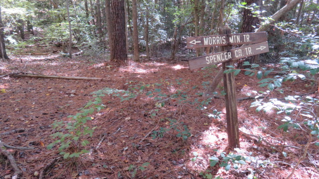
There is a sizeable mining complex of pits here. Lots of pushed up dirt, littered with quartz. The road turns into a single track and fords a creek. On the other side, I reach the junction with Morris Mountain Rd, or trail as the sign below indicates. If I turn left, I'll be at Spencer Creek bridge in a matter of minutes. Not wanting my adventure to conclude so soon, I turn right to take Morris Mountain Rd to Barnes Creek Overlook Rd. That sounded easy and looked easy on the map.
All went well until I ran into posted property owned by Uncle Jim's Sportsmen Club. Not wishing to cross private property during deer season, I followed the boundary around the property thinking I'd see the other end of Morris Mountain Rd. It was a bit of a detour and then I found a road about where I thought I would. Following it, I seemed to be heading in a direction headed east and not north. So, when I reached an intersection, I turned left and eventually headed west. But wait, I'm on private property again.


I worked my way in the direction I thought I should be going and ended up in the impact zone of this deer stand with door and sliding windows. It was on the top of a mountain so I tried to download a map. No dice. Neverthless, I starting tracking my route on geotracker. Even without a map, I wanted to see that I was going west and not circling back on myself. About a mile later, I found a timber road and followed it. Then I came to a 3 way junction. I'm completely at a loss which way to go. I turn right and end up a few minutes later on the UT and can make my way back to West Morris. Whew.


No comments:
Post a Comment