Friday, September 29, 2017

Sept 28 The new Profile Trail parking area


Grandfather Mountain State Park's new parking access for the Profile Trail is quite an investment. The fabulous building above, houses bathrooms and a gathering area out of the weather. The new access adds 1/2 mile to the length of the trail. 


Just in case you get your boots muddy, you can clean them up here.


Wanna camp? Sign up here.


 Looks like a jail with 3 electrical outlets. To charge your phone? or electric shock for littlebugs?


The parking lot has 100 spaces and the overflow area is below.


Sept 27 Snake Mountain


Snake Mountain is one of the Amphibolite mountains in western NC. It has two distinct peaks (South and North) with a mile long ridge between them. I have been on the South peak before, accessing it off Rich Mountain Rd. New signage posted along the road, indicates the owners no longer welcome hikers. So, it is off to another private access point on Meat Camp Road where I've read the owner is more welcoming.


The entrance to the private land is through this locked gate, with the chain just sufficiently long enough to get through. There is a Leave no Trace sign immediately after entering. Further up the mountain, another sign indicates hikers are welcome as long as the property is respected.


I think I'm looking at The Peak Mtn, just north of Elk Knob.


The route up the mountain is rather short but quite steep. In the lower 7/10s of a mile we are walking on a cleared road through fields. There are expansive view east and north. A large rock outcrop is reached and then the trail disappears into the woods by an old campsite. There is a overlook with a view of the Sunalei Preserve.


Here is a shot of the road to the top of the Sunalei Preserve. I noticed a trail coming from its main club lodge at the top of the road. The trail snaked its way through a gap in the rocks. At the top of this gap, I got the most delightful breeze both on my way up and back down.


At 5518', Snake Mountain has commanding views in all directions. The day was a bit hazy but I could make out most of the Amphibolite Mountains, Beech, Sugar, Hanging Rock, Grandfather and Roan. The Blacks were in the haze as were the Linville mountains and Grayson highlands.

Elk Knob

The last 3/10s mile is a gnarly climb. There are several trails following the ridge. Pick your choice, they all lead the same way. It is quite a scramble anyway you do it. At the top, I'd climbed 1146' and geotracker measured 1.16 miles and 18% average grade. Wow.


The trail just barely slips through here.


Sept 26 Backbone Rock & Falls


Backbone Rock Recreation Area lies just 4 miles south of Damascus Virginia. As you head south, cross into Tennessee, you will begin to see the beginning of the recreation area which consists of campsites, picnic areas and trails. There is a trail that connects to the Appalachian Trail but the trail that gets the most activity, is the one that climbs these stairs to the top of Backbone Rock.


Backbone Rock is a tall but narrow slice of rock that in 1901 was in the way of transporting timber out of the region. A tunnel, referred to as the "world's shortest tunnel" was cut thru the rock, allowing railroad access. After the railroad was abandoned, a state highway was built through the tunnel. Here we are 100 feet above the road below.


This photo shows the rock to only about 10 feet wide. Both sides drop off precipitously. A trail goes up and over the road. On the east die of the road is the main picnic areas. There is one large log pinic shelter from another era. The picnic sites have stone fireplaces which predate the more commonly seen steel pedestal grills we see elsewhere.


Too bad the road curves as it goes through the tunnel. It seems dangerous, since folks want to stop and take photos and walk through it.


This is the lower part of a 45 foot waterfall nearby. An old stone staircase leads to it.


Wednesday, September 6, 2017

Sept 3 Vade Mecum has a new trail


It is just a short spur trail and doesn't even have a name. When you visit the old mineral spring house at Vade Mecum, the trail is within sight. It goes just a short distance to the dam which created Diamond Lake in years past. Sitting next to the dam is the waterwheel which generated power for the resort.


Another dam in Hanging Rock State Park, is located nearby on the Moore Springs property. It is visible from the road if you know when to look. There is currently a picnic table located nearby which gets a fair amount of use. The dam itself is not is good shape and looks as though it has been crumbling for some time.

Aug 21 Eclipse on Pilot Mountain


The Friends of Sauratown Mountains hosted this event on eclipse day. Another support group, Friends of State Parks had donated about 600 viewing glasses. They had sent about 10 times that many to Gorges State Park for folks to witness the eclipse in the Zone of Totality. It rained there and they missed it. We did not.


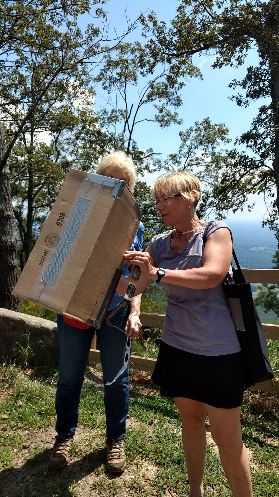
Enterprising folks built viewing apparatus to see the eclipse projected on a surface. 


Perhaps I should move out of the shade.


Everyone looks so stylish in their viewing glasses.The problem is that you can't see anything but the sun with them.


Our location would give us a 93% complete eclipse. One of the pleasant surprises for me, were the crescent moon shaped sun projections filtering through the tree leaves.


This family made it a science lesson. This gal is holding up a kitchen colander, projecting the eclipsed sun on a piece of cardboard. Enlarge the photo below for better effect. 


The sky darkened as it would before sunset but never got as dark as I was led to think it would.

We sent hundreds of glasses down to the park gate where cars were being turned away. The summit parking lot filled about noon. The eclipse began about 1:20, reached 93% at 2:40 and went on to about 4pm.

Glasses were handed out to those not able to get into the park. Most just viewed the eclipse by the side of the road outside the gate.

Thanks to Debbie Vaden for organizing this event.

Tuesday, August 15, 2017

Aug 8 Carratunk to Moxie Pond


We are doing a key swap hike today. We are the southbound group and there is another group going northbound on the AT. We have swapped cars back at Colby College before the hour and half drive to the trailheads. Our group of 8 is led by Maniac David, a low key guy. His counterpart, leading 9 going north, is a bit confused on the key swap concept and a couple of us roll our eyes as he tries to figure it out. We get that part right and we are off. Things go well on the drive until we get off blacktop. I am driving a Toyota Corolla with 150,000 miles on it. It is underpowered for this car of 4. When we leave the blacktop, we, once again, have a sheet with cryptic instructions. Look for this landmark and turn. We stop at almost every junction to talk it through. Along the way, we pass many ponds and see 3 moose and many ducks. We manage to find the AT right where it should be. 


Now we are on the trail. Somehow, my vision of this trail is much different than what I am seeing. We are climbing much more than I thought we would. We have a 12 mile hike lined up and somewhere about half way we will meet the other group and switch keys. I have a spare set of mine but they wouldn't do much good if my car isn't parked where it should be. How could that happen?


Just a couple hours into the hike, I am shocked to see we are meeting the other group. They must be incredibly fast hikers. No, their leader has led them to the wrong trailhead and cut the mileage by 5 miles. So now we are doing only 7 miles for the day. My eye rolling buddy and I glance at each other for the obligatory eye roll once again.


We swap keys and are on our way. It is close to noon so we are looking for a lunch stop. We decide it best to hike to the top of this mountain and get the climb over with before we eat. We reach what we think is the top and David points through the trees at the real summit, far above and away. Another 30 minutes and we settle down on the bare rock and look out over northern Maine. What a great spot to leisurely eat lunch. We have 5 less miles to hike so might as well linger.

The after lunch hike down is a steep one. It ends at a a pond where we take a break. Several of us get in the water to cool down. David wants to see some AT skinny dipping. That is not forthcoming.


After cooling off and getting geared back up, we are on the trail again. However, due to the snafu with the wrong trailhead, we are at the parking area in minutes. The drive back was uneventful and we arrived back on campus about 4:30, the earliest time yet.


Monday, August 7, 2017

Aug 7 AT South from Monson Maine


Our hike today is 10.5 miles, south on the AT from Monson. Jeff is our leader and we have a group of 8 from all up and down the east coast. Jeff thru hiked Maine in 2006 and that was the last time he was on this section. The drive to Monson had the normal number of wrong turns as I have experienced on each hike here. With little delay we arrive in Monson and turn onto Pleasant Street where the well known hostel, Shaw's is located. Looks like they had a full house as we drive by. Then we pass the sign for the start of the Hundred Mile Wilderness. Jeff says it is 107 miles but that doesn't have the same cachet as Hundred Mile. We park the cars for the key swap. We have already swapped cars with our counterparts headed the opposite way. The plan is to run into them on the trail and swap keys.


I spot many Lobster mushrooms on the trail. Never having seen one before, this is exciting. Of course I have no way to cook them while here, so they remain in place to be foraged another day. The woods are lush and the mud is thick. We walk on level trails for much of the mid morning. I am excited because we have two wet crossings. They are always fun.


Here is the crossing of the East Branch of the Piscataquis River. Say that five time fast. No problem here. Everyone made it without mishap and it was great to relax a bit pulling boots back on. 


The trail now follows the West Branch of the Piscataquis River for several miles. We don't get a clear look at it until miles later when we cross it. It is always obscured by tree trunks. It sounds happy as it bounces its way toward the confluence. Henry keeps us entertained with his bad jokes and sophomoric wit.


It isn't long before we reach the only leanto on this section. We flop on some rocks well away from the leanto to eat lunch. At this spot is a sign advising hikers of the Kennebec River Ferry. Jeff says the boat has a white blaze painted on its floor so the purists will be on the trail when they are in the boat. We find our counterparts eating in the shelter and the all important key swap is made with little fanfare.


We were a peloton for all morning but just after lunch it takes over a mile for the peloton to regroup. During this time, I slip off trail to this great swimhole and take a photo.


The 2009 map which seemed to be in ubiquitous use by our group, turned out to be inaccurate in that the route no longer followed streamside. It went up and down like a yoyo, requiring more of our energy. Finally, we made it to the second wet crossing. We were told it could be rock hopped but it would have been a wet rock hop.

Now, this is retirement living!


The rest of the route was an easy walk out. Check out this fearsome bunch, led by the alpha orange shirted Maniac. We loved this hike and are grateful to Jeff for taking time off to guide us.

Alas, the day is not over. We must find our vehicles and negotiate our way out of the timber company land. We were handed cryptic instructions which listed such landmarks as a purple bug box and a sign facing the opposite way. Almost immediately we were lost and made many turns this way and that, down roads we had to back out off and other fun stuff. Even with Garmin GPS, Maine Gazetteer, Siri and the cryptic instructions, we had a hell of a time solving this puzzle. Finally on blacktop, it became clearer but we did have to add a couple wrong turns, because that is just the way you do things here. 

Jul 26 Caraway Creek

Very fresh Chicken of the Woods There must be a decaying log or stump below.  Laetiporus cincinnatus is the whiter version of this fungus. I...