Monday, January 30, 2023

Jan 29 Hannah Creek's Dam


I did not intend to visit Hannah Creek's dam today but ended up here due to going the wrong way on Plantation Road. My original plan was to look for homesites and Old Jim's grave. Never heard of Old Jim? I didn't know either until I saw an old Joe Moffitt map with "Old Jim's grave" on it. I don't know who Old Jim was. Maybe just a dog? However, it was a good enough excuse to go out and look. Starting at Robbins Branch trailhead and proceeding to Hannah Creek trail and finally the old UT route now just a manway. Where the manway connects to the Birkhead Mountain trail, I located two chimney falls.


I searched around both for any ancillary buildings or other things of interest. I only found some piles of stones, not stackable. 


Here is a very large three trunked Tuliptree right in a stone wall. I knew I was near Hannah Creek, so I headed down.


Just before reaching Hannah Creek, I began following some red flagging and crossed this picturesque tributary. The flagging took me across Hannah Creek and another 1/4 mile before ending. I felt I was close to the private property, it was appropriate to turn around and get back to Hannah Creek. Finding a spot to cross is usually difficult but as soon as I came upon the creek, there was a creative rock hop. Bushwhacking up from the creek I came upon Plantation Road. Knowing where I was, I promptly turned the wrong way and ended up back at the creek right by the dam.


Joe Moffitt's book says the Binghams had a mill here. It looks like classic detention dam, so no mill. There is a rock wall on both sides, nothing in the middle. The walls are constructed with the highest point on the down creek side, sloping downward on the up creek side. The ford was just down creek. I'm not aware of any other dams on Hannah Creek but I have not followed it on private land once it leaves the national forest and empties into the Uwharrie River. There is a large pile of rock creekside in the horseshoe by Bingham Graveyard but it does not have a "dam" shape and is only on one side. 

You don't see this often

After climbing on the dam, I headed back up Plantation Road back to the Birkhead trails.


Jan 28 Soco Falls


Soco Falls is a double waterfall. The main fall is on Soco Creek. To the left of this photo, is a second creek with a waterfall also. The trail to the bottom was icy so I was not able to get a photo of both side by side. 


The pulloff is not signed but it is large and hard to miss. Getting back onto the highway is uncomfortable since you have curves in both directions. 


Jan 27 Albright Grove


Another WWW hike being led by David Morris and Charles Maynard. We are bused to the trailhead for the Maddron Bald Trail. It is another cold morning. The uphill climb is welcomed to get us warmed up. First stop is the Willis Baxter cabin about a mile from the trailhead. 


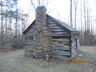
The cabin is made from Chestnut, possible from one tree. No windows made this a dark place to live. 

A nurse stump helped this Yellow Birch get started


As we entered the Albright Grove, we are stopped by this large Hemlock. We could have slipped underneath like the two park employees just in front of us did. However, the decision to just go out and back on part of the loop was made. David and Charles are very familiar with this area since they had adopted this trail for several years back in the 1990s. 


The snow made the hiking on the Albright grove loop a bit slick. The grove is named for Horace Albright, the second director of the National Park Service after Steven Mather. Albright was also park superintendent of Yellowstone for 8 years. 

Silver Maple with a hollow bottom

Silverbell with an odd base.

Big Tuliptree


Most of the big Hemlocks in the grove starting succumbing to the Hemlock adelgid about 30 years ago. Once the dense canopy was gone, many young trees have taken root and even some of the giants have sprouted new growth now that they are in an open canopy. Many of the large trees here have had their tops blown out.


We climbed to the highest point in the grove for a lunch break. Footing was far from ideal. 


This is the top of the big Hemlock which is pictured earlier. It is a fresh fall and we were the first to encounter it. 

The bridge over Indian Camp Creek is one of the longest in the park.

I can recall having to climb over this Hemlock back when it was a fresh fall. 

Our hike was a bit over 7 miles. The return walk downhill was a very pleasant one. There are several homesites and we saw many stonewalls, a couple spring boxes and the handiwork of the Civilian Conservation Corp which build the trail in the 1930s. Their camp was near the trailhead in a flat area. The trail is still used by park vehicles for the first mile and a half. Park employees must get permission to open gates and drive in. 


Jan 26 Laurel Falls & Little Greenbrier


After a 7 year hiatus, I'm back at Wilderness Wildlife Week in Pigeon Forge. Five of those years WWW had moved to May and several of us organized Winter Hike Week as a January replacement. I was thrilled to see 5 old friends on today's 8 mile hike. Our leaders are David Morris and Charles Maynard. We begin hiking at Fighting Creek Gap up the Laurel Falls trail. We all know the first 1.3 miles of this hike is the most hiked trail in the park. It is paved to boot but it is scheduled to be repaved in the near future. The pavement has been deteriorating for years. 


Laurel Falls as seen from the footbridge. We are the only hikers here early on this frigid morning. 


Temperatures are in the mid 20s with some wind, so we are bundled up and everyone wants to keep moving. Our hike continues to climb. We enter old growth forest with many large Tuliptrees. 


Here is a recent uproot. Some hikers have a difficult time getting over it. 


We are dwarfed by the big trees. Snow comes and goes with one snow squall engulfing us for several minutes. 


We climb for another 2 miles to the junction with Little Greenbrier trail where we take a break. All our breaks tend to be in open and exposed areas. 


David and Charles give a short presentation in the old schoolhouse. Charles tells us, the school house also served as a church and community building. Charles is very fact specific. He was the first director of the Friends of the Smokies in the 1990s. He has written a number of books about the smokies. As an author, he pales next to his romance novelist wife Janice. 


Just before reaching the Walker Sisters cabin, our group encounters another WWW hike group. Together we lunch on the Walker Sisters cabin grounds. The cabin is undergoing an extensive renovation. Charles explained the Friends of the Smokies had received a grant from Log Cabin Syrup of over $250,000 to renovate log cabins in the park. The original grant specified that the funds needed to be spent within a year. Finding experienced craftsmen to renovate these old structures made that impossible. Log Cabin Syrup agreed to extend the period and the Friends matched the grant. So, the renovation here is made possible from the 1999 grant. 

After Charles' presentation, we were treated to a singing performance by one of the hikers, also a professional singer. 


Wednesday, January 18, 2023

Jan 16 Woody Ridge, Celo Knob and Gibbs Mtn


I'm exhausted

Woody Ridge Trail, considered one of the most difficult trails in North Carolina, is covered in snow and ice today. It is relentlessly steep. Will and I leave the car about 9am just as another hiker pulls into the tiny parking area. She later catches us and powers up the trail. We see each other several more times. "Lynn" as I will call her, is from Linville Falls, mid 70s and a very fit and knowledgeable hiker. There is a particularly steep section of trail she tells us is know as "Devils Half Mile" since it rises 1000 feet in that short distance. It seemed to me that the entire 2.2 mile trail was that steep except for the bottom and top portions. 


There is only one set of tracks in the snow - Lynn's. We greatly appreciate her ability to break through so we can use her footsteps, not only as a guide but making the uphill slog a but easier. Eventually, there is a coyote track that follows the trail. Coyotes utilize a stepping pattern in which their rear foot steps in the hole the front foot has made.  


The snow gets deeper and trail gets steeper. It's time for micro spikes. 


Without footprints in front of us, this trail would be hard to follow. There are yellow plastic blazes but they are far apart. 


Our first nice view occurs about 3/4s of the way up. This is Lynn's turnaround spot. We spend a few minutes talking. She gives up very specific directions to locate the manways to Celo and Gibbs. Now, we have only the coyote tracks to follow. As the snow deepens and the drifts occur more frequently, our pace slows and we need to catch our breath more frequently. We take turns breaking snow. 


It's close to noon as we top out at the Black Mountain Crest Trail. We follow it to the right about 3/4s mile to the manway up Celo Knob. The manway makes its way very steeply up. It is a slow go but we manage to top Celo where there is a very limited view. After descending Celo, we break for lunch about 1pm. there is still time to return back on the BMC Trail past Woody Ridge another 1/2 mile to the bushwhack up Gibbs. BMC Trail is full of drifts. Some are 18" or more, making walking slow and deliberate. We continue to take turns breaking snow. Only coyotes have used the trail before us. 

Cane Creek area comes into view

I wondered what the coyotes were after.


Finding the way up Gibbs was not easy. We located a spot that looked as good as any and headed off trail. It was about a 100 yard bushwhack up. It looked like any one of three spots up top could have been the highest spot. We did a congratulary high five on top. I was pretty tired at this point but the fact we were headed down now gave me new energy. 


Lone view atop Gibbs


We are headed down Woody Ridge on schedule. At first, the going is easy. The deep snow makes footholds easier. However, as we descend into less snow and steeper trail, it becomes slick. We both fall 4 or 5 times and every few steps is a slip, even with micro spikes and my hiking poles. 


Our paces slows due to the slick trail. It seems to never end and we wonder how on earth we crawled up this steep trail. We encounter a young couple from Wisconsin at one point. They are turning around as the steepness and slick conditions have taken a toll on them. They would not have made it out by dark if they had tried to top out. 

My last fall sends a pang of pain through my lower back. I am very concerned as each step is painful. My pace slows to inching along. Fortunately, my back recovers enough to make the return to the trailhead without significant pain. We're back at the car about 4 pm, both sore from the steep climb and descent. The hike ends up being just about 6.5 miles but one of the most difficult I have done in recent years. 

I got to cross off two SB6000 peaks - Celo at 6327' and Gibbs at 6220'.


Jan 4 Upper North Prong Hannahs Creek

  Hiking from the dam at  Plantation Road, up the creek toward Fern Valley. I've did this years ago but don't have any photos, so he...