Saturday, May 23, 2020

May 17 Russell Dome


The bars are closed in NC during Phase 1 of reopening, so are the mines. A sign warns you not to commit tresspass. Tress is the Latin word for beyond. 

We started with an exploration of the Russell Mine area. I had never been to the area referred to as the Big Cut. We made our way to the area with the barred off shaft above. You could feel the cool air coming from it. To get to the Big Cut, we headed off on some old roads.


The first thing we saw, was another barred off shaft which resembles a culvert opening. Then we made a detour around a huge depression, possibly the Big Cut. 


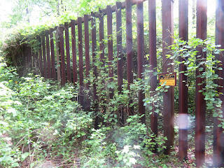
Giving up, we headed on an old road and came upon this hard to miss structure. There was a vertical drop off just beyond this barred off area. The exclosure is roughly square and quite tall and large in area. It's a great place to grow vines.


Next stop is an unnamed mountain which I am going to call "Russell Dome". That is the name I saw on a geologic map of the area back in the mining days. It was a bit of a trek to get to the base of the dome. We followed a graveled Forest Service road until we saw a 4 wheeler track going up. It was really steep but only about 200' TEG. Not much to brag about on top. No open area, no view. Just a bunch of grape vines taking over from the last timber cut.


After a brief rest on top, we head back down. Now we head toward the Uwharrie River and walk toward Big Creek for a look see off the confluence. Then it is back to the gravel road abd back to the Russell Mine. While here, it is hard not to visit the massive rock structure that housed the mining operation.


May 14 Little Long Mountain's Prickly Pear


It's that time of year again. During the 2nd Thru Hike, we got to cross Little Long Mountain about this time in May. That's when the Pickly Pear blooms. I started out from Joe Moffitt Trailhead and headed up. Near the top there is a patch of Galax before leaving the forest. This one is almost fully bloomed out.


Now it is showtime. Pickly Pear blooms are stunning. Check these out.


A little bit of Yarrow tried to crowd in

Blue Eyed Grass


The view has a nice background and foreground today.


Fire Pink trailside. The shelter is sporting a new logbook. I don't know who put it there the day before yesterday, but thank you.

May 8 Birkhead South


Following CDC and Mandy Cohen's guidelines for safely hiking, ten of us spread out for this jaunt into the forest. We were checking the condition of Birkhead Mountain Trail, the southern dead end portion. It hasn't been used much lately. We also wanted to see how we could cross Hannahs Creek near the trail. A scout built bridge washed away years ago and the trail was abandoned south of Water Camp. When we arrived at Water Camp, we met a backpacker out for an overnight. 

We walked toward Hannahs Creek. The group crossed in 3 different places each one a wet one. Once we reached Malfunction Junction, I led a group to Bingham Graveyard while others wanted to check on a downed tree that had been reported.


Once we reunited, we split again, with a couple headed on the Birkhead Mountain Trail and I leading a group on Plantation Road. Never having been on Plantation Rd before, I needed to rely on the GPSers with us. When we came to the creek crossing, we spotted the aluminum plate sign informing us the scouts had constructed a bridge here March 6 1978.

Twayblade Orchid

After finishing the hike, driving along Strieby Church Road, this guy was watching us.


May 1 Checking out Silver Run


Robbins Branch Trail looks like it has hail on it. It is just another Uwharrie quartz deposit. This section of trail has a lot of it at its high point.


To get to Silver Run, you have to figure out which tiny creek on Thornburg Trail is the right one. Or just take any tiny creek, they all end up in Silver Run. This area suffered quite a bit during the wind event last June. Many large oaks uprooted making for many detours as I followed the creek.


Mouse Ear Coreopsis made an appearance for me today.


I walked a long way downstream before I spotted a Jack-in-the-Pulpit and then they were everywhere. I got a bit off track and ended up following some old roads which led me back toward the junction of Thornburg and Robbins Branch trails. That was not what I wanted. Eventually, I got some phone signal and got Geo Tracker fired up, located the trailhead and headed the right way.

Apr 10 Cooper Mtn Hike


Hiking Cooper Mountain Trail requires crossing Hannahs Creek. It almost always is a wet crossing. I knew that and prepared with high boots and gaiters so I didn't get wet. The trails are being used a lot. Robbins Branch looks like a boulevard. A muddy one. A bit more trash than normal too. 


Right by the crossing, I spotted a Crossvine bloom on the ground. Looking up, I could see a wonderful sight. It looked like the tree was blooming.


For a very short period of time, this White Fringetree blooms with its strikingly long wispy petals.


A Nodding Trillium tries to hide under its foliage. 


Foam Flower right next to the creek, trying to catch my attention.


Another bloom trying to hide, this Mayapple looks like it has a Christmas Fern growing from it.

Jan 4 Upper North Prong Hannahs Creek

  Hiking from the dam at  Plantation Road, up the creek toward Fern Valley. I've did this years ago but don't have any photos, so he...