
Cahokia is going to see an uptick in recognition and visitation. Legislation has been introduced to elevate it from an Illinois State Historic Site to a National Park.


The timeline for Cahokia dates back to the Late Woodland period around 700 AD. Although there is evidence of older camps in the area, this spot seemed the perfect place to set up a city once agriculture seeped into Native American culture.
Around 800 AD Mississippian Culture begins to take hold. Known as "Mississippian" because its origin is centered along the Mississippi and other tributaries. This particular spot is a 8 mile canoe paddle from the Mississippi. A short distance from here, is the confluence of the Missouri and Illinois Rivers. Downriver is the Ohio and of course, further along, the Gulf of Mexico. The center of the culture was here at Cahokia, but spread throughout those river systems and even into our area of North Carolina.
Not only was it a transportation hub, but it was in the area now known as the "American Bottom", a 175 square mile floodplain with ample lakes and wildlife.
It was also about this time, the transition to agriculture began with maize being the stable crop, supplemented with beans and squash.

By 900 AD, the population is estimated to have been about 1000. Its population remained relatively stable until about 1050 AD. Cahokia begins a major expansion for the next 200 years. The village grows to a city of 20,000 with 50 sub communities comprising another 20,000. The city expands to 6 square miles. The discovery of chert, a stone found nearby at Mill Creek may have been a key ingredient to Cahokia's importance. Chert was fashioned into many tools. There have been multiple caches of chert axes found in the area. These highly polished tools would have been an excellent trade item. They have been found throughout the Mississippian region.

The layout of Cahokia centers around the Grand Plaza and Monks Mound. There are 120 mounds in the vicinity and many more in the surrounding communities. St Louis itself had many mounds as well. In 1819 a survey was done which included 25 mounds in present day St Louis. The largest, "Big Mound", was a site to behold. At 34 feet high and 319' x 158', it was a giant landmark used by riverboats. In 1868 it was destroyed and its dirt was used as fill for a railroad. All the other mounds except one, succumbed to development. The only existing mound, Sugar Loaf was purchased and now owned by the Osage Nation of Oklahoma. They and many historians, believe, the Osage descended from the inhabitants of Cahokia.

The mounds are different shapes. It is not known why, but likely they had different purposes. Many were excavated or destroyed before the state began preserving the area. Now, excavations are only being done with cooperation and approval of Native American interests. Many mounds contained burials and need to be left undisturbed. Mound 72 was one that was excavated partially. It is important to note that a post on Mound 72 lined up with a post on Monks Mound, leading some to think it has some importance. A burial was found in the mound, likely containing a chief or important person. His remains were set on 20,000 shell beads arranged in the shape of a falcon. Arrowheads from different regions were also there. Another 250 bodies were also found. Many were probably sacrifices. Fifty of the bodies found together were females, all about 21 years old. Another 40 male and female bodies appeared to have died from horrific beatings. Some were buried alive since their fingers were found to be in positions as though they were trying to dig their way out of the bodies above. Was this the most lavish burial? No one knows. Maybe the other mounds have burials in them or maybe they had other purposes.

On top of Monks Mound
There were at least 5 wood henges on the site. All were aligned to coincide with sunrises throughout the year. There is a reconstructed one on the site but it was a short drive away and we did not get to it.

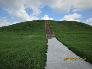
Heading up Monks Mound
The layout of Cahokia centered on Monks Mound and the Grand Plaza just below it. The mound is 14 acres, roughly the same footprint as the Giant Pyramid at Giza. At 100 feet high its the tallest mound north of Mexico. It had a flat top and had 4 terraces. There is evidence of a large structure on top along with a number of smaller ones. St Louis and the Gateway Arch are easily visible from this vantage point.
All of it is constructed from basket transported soil and clay.
The name "Monks" derived from the Trappist Monks who occupied a nearby mound beginning in 1809.
In 1930 a local built a road to the top and constructed his house. The significance of the site was slow in developing. Many mounds were long gone by the time conservation efforts began in earnest. ATVs used to run up and down the mounds until about 2000. Just a few years ago, a fellow drove to the top, jumped out and started digging. And he was not trying to be stealthy about it, driving a corvette.

Beginning about 1175 AD, a wall was built to enclose the site. It was 2 miles long and may have resembled the reconstructed wall above. Over the next century, 3 more walls were constructed. They had guard towers evenly spaced apart. This was an obvious attempt to protect the city but it's not known from what. Population began to decline about 1200 AD. By 1250 AD, it was only a shell of its former self. By the late 1300's, it was completely abandoned. What caused this is speculative. The demise of the Anasazi occurred at the same time. So the prolonged drought that occurred at that time, may have caused resources to become scarce, leading to conflict.

When the French arrived here in 1735, a tribe of Native Americans was living nearby. Thus, the area was named for this tribe, the Cahokia.


No comments:
Post a Comment