Russ and I have a special hike planned for today. We'll be leaving a car at the Profile Trailhead on 105 and taking another vehicle to the Grandfather Mountain Swinging Bridge to start a hike. You can do this, although it is discouraged and the $20 per person entrance fee would make this a $40 per person option. That is all negated if one of you has an annual pass. Hiking partner Russ was a personal friend of Hugh Morton and has for many years received an annual pass. So we can do this hike on the cheap.
First impression is, the door is almost ripped off the car when we open it at the top, The winds are gusting into the high forties. We can't put sunscreen on outside, so retreat to the restroom. Once we are geared up, we head into the wind and it is ferocious until be get sheltered in the forest.
Above you can see one of our destinations, MacRae peak.
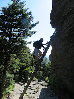
The terrain is so difficult, ladders and cables are needed to negotiate the steep ascent. The wind makes it more difficult on the ladders.
Some are long and tedious, like this one Russ is just starting up.
The final ascent to the top of MacRae is this ladder. Many a photograph has been taken here.
That's next. Get a good breather and choke down some protein before tackling this.
After leaving MacRae at 5844', we head down to a gap and tunnel through the rock jumble before heading up the chute. The chute is in the photo above, just off the left side. At the top of the chute is the Attic Window at 5949', our highest point today.
We manage the final leg on Grandfather Trail, taking 2 hours to go 2 miles. Now it is 3.6 miles down Profile to the new trailhead, It is very rough and rocky trail for the first .5 mile and then it is just steep and a little rocky. About the time I am ready to be finished, the trail to the old parking lot is blocked and we head up. And we head up. It is a long upward climb to get to the new trailhead. We manage to hike the 5.6 mile trail in 5 hours.


No comments:
Post a Comment