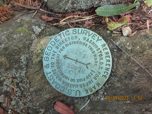
I know it says Black Mt but we're on Mt Hardy, I'm certain. It may have been Black Mt in 1933 or someone thought they were on nearby Black Mt.
Dodder Vine or Love Knot
Today's hike is on the MST. Our trailhead is on Rt 215 just off the Blue Ridge Parkway. Once we step off the road, we are in Middle Prong Wilderness. Due to wilderness regulations, there are no MST blazes nor trail signs. We're on our own. The first quarter mile is up and down with large of rock. Then things level out and we are on a railroad grade. We follow the railroad grade all the way to the Mt Hardy turnoff.
First (and only) glimpse of Mt Hardy
The railroad would have been for logging. So, once the logging was finished, the tracks and structures were removed. We saw twisted wire cable in several places and even a length of rail, discarded for some reason. There were open areas slowly being reclaimed by forest. These may have been loading decks or possibly a shantytown.
A nurse stump tree
We walked through some wonderful boggy areas. The bedrock in some of these spots is only 18 inches below. Sometimes, these places don't have anywhere for the rainwater to drain away, thus retaining the moisture to form a bog.
Mosses love bogs
Although, the 3 mile trek to the top is 1000' in elevation gain, the first 700' are evenly spread over the first 2.5 miles. The route to the top leaves the MST for a 1/2 mile track up. It starts out like a real trail but becomes overgrown quickly. Using Alltrails navigation to see the route helped much.
Cool club moss
Another cool club moss
When we reached the USGS disc, the trail seemed to continue and we were not convinced we were on the highest point. Will used his Avenza app to measure the elevation. after a good 20 minutes of walking from one spot to another, we concluded that the disc was very near the highest point. Here we sat for a nice lunch break.
On our retreat back to the car, we passed several hiking groups and a fellow from Winston-Salem looking for waterfalls. He told us of one he had just bushwhacked to nearby. Near the trailhead we passed a couple with a ferocious poodle dog. They were hoping their favorite waterfall campsite would be available. It is located on the trail to Green Knob very near the spot we left the MST to access the Mt Hardy track. A different waterfall than the other guy had visited.


No comments:
Post a Comment