Friday, May 27, 2011

May 26 Boone Fork Trail


Today's hike on Boone Fork Trail was to get a better look at a hike I'd like to lead for Piedmont Hiking and Outing Club later this summer. Never having walked this trail before I carried my autographed copy of Randy Johnson's hiking guide, my Garmin GPS and was accompanied by two seasoned PHOC hiking companions. 

The trail is a 4.9 mile loop. Mileage is measured and signed beginning at the Price Park Picnic Area on the Blue Ridge Parkway. Rather than start our hike there, we chose to continue along the BRP a short distance and access the Tanawha Trail on Holloway Mountain Road. That decision led to a couple encounters with a road grader on a narrow winding gravel roadway. Eventually, the trail head was located at a wide spot in the road and we embarked on the Tanawha Trail. In the Cherokee language, Tanawha is a "fabulous hawk or eagle". Hence the trail is signed with a white feather.

We followed the Tanawha Trail for less than a mile awed by the brilliant flame azalea displays. At this point the Tanawha "t's" into the Boone Fork Trail. We have the option of going in either direction and opt to go left following the MST as well. There are some mucky areas and a couple of stream crossings that require steady nerves. The trail and Bee Tree Creek morph into one another at a couple points assuring wet boots.


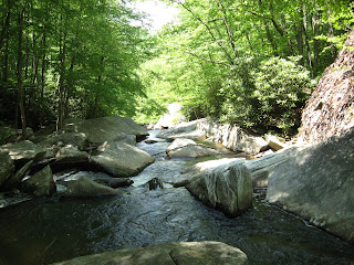
Bee Tree falls into the larger Boone Fork and the trail hugs the steep banks of Boone Fork for a couple miles leading to the picnic area. There are water falls, cascades, magnificent rocks and rugged terrain. One short ladder needs to be negotiated. Be sure to check out the cave at the top of the ladder. As we approach the picnic area, many more people are encountered. This appears to be a big weekend draw as there are many side spurs leading down to the river.


The picnic area is a series of open fields with a narrow strip of trees protecting a small creek. Although the trail officially starts and ends here, we continue on, passing through the campground and beside another bathroom before heading back into the wood. From this point it is a short stroll back to the Tanawha Trail and our vehicle parked on a newly graded gravel road.

The total mileage is between 6 and 7 miles and the elevation gain is mere 900 feet. So for PHOC rating purposes this is a a pretty easy hike. Due to the creek crossing and rocky terrain I will rate this a R-21. Still an easy hike. 
Monday, May 23, 2011

May 22 American Tobacco Ride


Today's ride was an out and back cycle of 27 miles from the New Hill access to the current end of the trail at I-40. The ATT will someday bridge over I-40 but we are not at that point yet. The trail is in great shape and we did not see one horse all day long. There were lots of folks out enjoying this trail. Many families were using it which is always a good sight.


At a couple road crossings, local businesses had set up water coolers for those folks who didn't bring enough. There is no normally no water available at any of the parking accesses or rest stops. being a hot day as today was, that is something you should keep in mind.


The only wildlife encounters were a large black snake and a snapping turtle trying to make his way across the trail. Oh and the cicadas. They were deafening.

Photos here were taken by Susan McElveen

Saturday, May 21, 2011

May 21 Smith River float


Thanks to Ken Yates for organizing today's paddle on the Smith River in Virginia. We used the services of an outfitter, 3 Rivers, in Eden to arrange a shuttle. Their office was the former office of Spray Cotton Mills a long time cotton yarn spinner in Eden dating back to the hydro powered mills days. 

Today's float was 12 miles along the Smith River benefiting from the daily Philpott Dam release. The water ran swift and cold. Mountain Laurel decorated the rocky slopes of the river. An adolescence otter greeted me in the first hour, followed by a fox squirrel, Osprey, Red Tail, numerous ducks, Canadas and as always a GB Heron.


Lunch was on a stony island with a small patch of shade all 10 of us crowded into. No mishaps during the day. But, below, Ken and "Wrong Way Shirley" can't figure out why they aren't going anywhere when both paddle.

Saturday, May 14, 2011

May 3 Cotswold Way into Bath


The small village of Cold Ashton was the first area I walked through today. It was as picturesque as the Cotswolds get. Next I crossed a busy highway and then was onto a small country lane. Several vehicles came along and I had to step into the hedgerows to get out of the way.


Scenic views were the theme today. All the way into Bath there were great views. The city I saw most of the day was Bristol not Bath. the final couple miles turned toward Bath and it was finally in my sights. The fellows I met the night before at the farmhouse dinner, came along and we walked together into Bath. The trail signs into Bath gave out long before the center of town. I managed to find the way with maps.


I finally found the place I had booked and it was not the best place but I understand Bath is an expensive place and people pay lots of cash to stay in less desirable locales.

May 2 Cotswold Way from Old Sodbury


A new plan developed this morning. My ankles were so inflamed with heat rash, I had to wear sandals. Knowing I could not make it to Bath in 2 days - about 40 miles, I opted to get a ride to Old Sodbury, about 20 miles down the trail and continue from there. So that is what I did. 


Old Sodbury was a small village and I was soon out of it and back in pastureland. The village of Tormarton was beautiful. I enjoyed walking through it. 


I managed to get to my destination in Pennsylvania by mid afternoon. The b&b was next to a busy highway so there was a bit of noise. However, there was a gas station/convenience store next door so I was able to get some cider and snacks. that evening I learned the local pub was closed but there was a farm nearby that provided meals. I made arrangements to eat at the farm. It was about 1/2 mile away - just a short walk through a field. The meal was nothing special but it was better than gas station snacks.

May 1 Cotswold Way Painswick to Dursley


I started out rather early today. the trail narrowed down between a couple homes, as shown above. Not far from here I passed the halfway point of the trail. There were more longbarrows, round barrows and hilltop forts today. I encountered lots of folks on the trail today.

 The hilltop scenes were great today. It was relatively clear and you could see yellow fields of rapeseed far in the distance. It was during today's hike, I started really having difficulty with the hot spots on my ankles. I think they were due to the synthetic material in my socks. I limped into Dursely.

The place I had booked was near town and directions were given. However, I had a great deal of difficulty finding the place. As I was wandering around downtown, an elderly woman asked if I wanted some tea. I replied I was looking for Shakespeare Inn and she said something about having tea and then going there. I didn't know what to do so I eventually went along with her to the town hall to have some tea. As we entered, the proprietor of the inn greeted me and introduced me to her elderly sister whom had dragged me there. So I had afternoon tea and then caught a ride out to the inn which was about a mile out of town.

I evaluated my option this evening. My ankles were red and sore and I didn't think I could put my boots back on. I all but decided to take the train from town to Bath in the morning.

April30 Cotswold Way to Painswick


This morning I started with wonderful breakfast prepared at California Farm. The bacon was cured locally. Although it looked like country ham it did not have a salty taste at all. There was dew in the grass and I saw many large snails. I assume these are the snails folks forage for a tasty appetizer. Also I saw many black slugs which did not look very tasty. The snails didn't either to be truthful.


More hills today. Lots of pastures and field to cross. And another golf course was part of the trail.


Painswick is a rather large village with 2 pubs and a couple bistros as well as a number of B&B's. I stayed at Tibbiwell Lodge. Is that an English name? I met a couple locals in the pub and had a great evening.

A Belted Galloway

April 29 Cotswold Way from Wood Stanway


A staddlestone barn along the trail today. I walked through many sheep pastures today including the one below which was perhaps the largest I encountered all week. 


Further along today, I passed the ruins of the once grand Haile Abbey. At one time it was one of the, if not "the" largest of all the "wool" churches. Beyond that was the fabulous longbarrow, Belas Knap, perched on top of a hill. This group burial chamber was used beginning in 2500 BC. Around noon I crossed Cleeve Hill. A golf course encompassed the entire top. The trail goes beside and through the course so you need to mind the golfers when they tee off. The views from Cleeve Hill were great.


The rest of the afternoon was spend in and out of wooded areas. Yesterday I saw tons of bluebells, today it was ramsons or wild garlic as in the photo below. By the end of the day I was quite tired. On the long uphill walk to the California Farm where I was booked for the night, the owner came along and gave me a lift the final half mile. It was a beautiful home, set back in the hills on a long private drive. The hosts were very gracious. They even gave me a ride into town so I could eat at one of the pubs. My room was the nicest one I slept in during my walk.

Tuesday, May 10, 2011

April 28 Cotswold Way from Chipping Campden


Getting to Chipping Campden was a simple train ride from Paddington to Moreston in Marsh, then a bus ride of about 20 minutes right to the start of the Cotswold Way. Here is the "Beginning and the end" stone to mark the spot. Chipping Campden is a typical large Cotswold village. There are many 400-500 year old limestone buildings with small lanes or hedgerows between them. I was out of the town limits in about 15 minutes.


Walking was fairly easy. The trail was smooth dirt. You need not look out for rocks and roots. The trail was about the only place you did not see rocks. The limestone was everywhere, walls, plowed fields, homes and barns of rock etc. One of the first things I noticed was the quantity of flowing plants, bushes and trees. It seemed as if everything was in bloom, including this rapeseed below. The EU pays UK farmers to plant it but not harvest it. The purpose is to replenish the soil and prevent the farmers from planting wheat, thus maintaining a higher wheat price. Sound familiar?


I passed by the tower in the bottom photo. It was actually a folly built in 1795 which later was home to several businesses. Its original purpose was as a signal tower, alerting manor staff that the master and misses were enroute. I think it also had a bathtub on top, so master and his pals could relax in an 18th century hot tub with a view. Carrying the water up must have been a chore.

The weird stone below is a staddle stone made of carved limestone. This particular one is 400 years old. Their purpose was as foundation supports for barns and storage bins. Rats could not climb up into the barns with these stones used as supports below.


As the day wore on, I grew tired and hoped to find a place to stay. The 3 B&B's in Stanton turned out to no longer be in business or maybe no one was home. So it was on the Wood Stanway where I did find a farmhouse B&B with a room. Only problem was, nearest pub was a 1 1/2 miles away and the owner didn't drive, but there was a short cut across a field. I missed the short cut and had to walk along the side of a busy road with fast moving traffic. The pub was nice and I settled for some lamb steak and cider. I found the field path on the return and had a pleasant evening walk along empty country lanes.

April 27 Stonehenge & Avesbury


It's a chalk horse. Dig down a little and you hit chalk. So why not create some art as this local farmer did in 1805 in honor of one of Napoleon's defeats.


There are almost a hundred stone circles in the UK and this one is at the top of the heap. It is actually the 3rd stone circle built on this spot. Earlier ones were removed to make way for this one of massive stones. No one know why the others were built or removed. No one knows why this was built. The stone was quarried a long ways away and had to dragged here. The top stones were notched and fit over carved pegs in the upright stones. A couple of the top stones have fallen or were removed, so the henge looks worse for the wear.


Because the henge aligns the summer and winter solstices, many think it was a giant calendar or place to worship a sun god. There is evidence of a road from the henge to the nearby River Avon, so some assume, the road leads to where the local settlement would have been on the river.


Not far from Stonehenge is another stonehenge in Avesbury. It is a mile long and contains stones as the picture above indicates. Over time some of the stones have been removed for local building projects. the removed stones have a small monument, like the one in the picture above, to indicate where they would have been in the circle. An interesting note here: because of the size of this henge, it is the only henge in the UK with a pub inside of it. We stopped in the Red Lion pub for a drink before the coach trip back to London.

April 23 Little Venice


When I first heard Pam would be staying in the Little Venice area of London, I thought it would be the Italian section, just like Little Italy in Manhattan. Later I learned it had nothing to do with Italy or Italians. It was the canals.


Little Venice is the spot where three waterways come together and form a triangular lake. The canals are Paddington Arm, which seems to dead end a short distance away, Grand and Regents.


You can walk from Little Venice to Paddington Station along a canal, to Camden and the London zoo. Most of the routes are lined with canal long boats converted to living quarters. These are the permanent homes of many people. They tend gardens on the top deck, store firewood there as well and have many unusual adaptations to their boats.


There are cafes on boats, water taxis and boats you can rent for business meetings complete with all the audio visual and computer gear.

Best of all, the canals provide a pleasant greenway through an otherwise grimy city.

Jan 4 Upper North Prong Hannahs Creek

  Hiking from the dam at  Plantation Road, up the creek toward Fern Valley. I've did this years ago but don't have any photos, so he...