Sunday, May 24, 2015

May 23 Tanawha hike


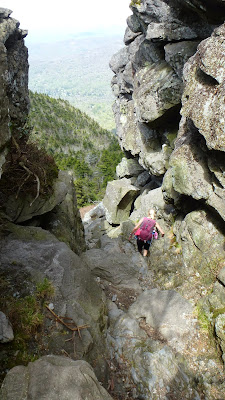
The best part of the Tanawha Trail is the section between Rough Ridge and Stackrocks. So why don't we just hike that section, in both directions. It is a seven mile jaunt without terribly strenuous terrain. It is a lot of rocks and roots.


This meetup hike is being led by longtime friend Jean Hylton. Wait a sec, it is being led by me. As we pull into the parking area, Jean tells me I am leading it. I have to assume she has deferred to my seniority as a longtime hiker and amateur naturalist. Or was it just her abrasive personality (hope she doesn't read blogs)? 


It was a great start. We see lots of wildflowers and I only misidentify a few. Here we have Catawba Rhododendron and Sand Myrtle. There is lots of Clintonia, Umbrella Leaf and a single Pink Lady Slipper among the usual suspects.


Amid the wonderful rock formations I have digitally captured some of nature's tree art.


There is a short side trail off Tanawha Trail which leads to this wonderful view of Linn Cove Viaduct. Only Jean and I took a moment to visit this spot. We met a biker from Florida taking in the view too. It is probably the best view of the Viaduct I know of.

May 20 Virginia Creeper Ride


This ride is from just outside Abingdon to Damascus and back, the quiet end of the Virginia Creeper Trail. It was a sunny day and low temperatures and humidity. If there is a drawback to this section of trail, it would be the gates which need to be opened and closed as you travel through. I think there are 6. Two of them have a very powerful cylinder to close the gate after you have opened it. It is tricky to open and close it without a powerful thud against your bicycle. Two of the gates have cables with weights on them, making it easier to get through them without having to close the gate.

Bridge over Holston River

A new restroom has been built in Alvarado in a beautiful depot style building. The store next to it is under new management geared to serve trail users. For a pleasant side excursion here, it is one half mile to the Abingdon Winery, set next to the creek. Actually, I think you have to ford a small side creek to arrive at the tasting room.

As I arrived in Damascus you could see vestiges of the recent Trail Days festival which concluded days earlier. I passed several thru hiking couples making their way along the AT, which here, is the sidewalk. I think virtually all that hike through town, hike through MRO, MT Rogers Outfitters. It looks like there is a new hostel right next the Food City grocery store. How convenient. I should walk through that store sometime to see if they are geared to serve AT thru hikers. 

Bridge #7

What a history, Bridge #7 has. Originally built in the 1890s, it served the Carolina Virginia Railroad, aka Virginia Creeper for almost a century. Then it became part of the railtrail. In April 2011, a tornado lifted it up and twisted it into pieces. Four people lost their lives in nearby Glade Springs on that day. The town of Abingdon which owns the trail here, had the bridge insured. The first order of business was to remove the debris and construct a temporary trail bypassing the bridge. It took over two years for a new bridge to be completed. Here it is.

Bridge # 7 with trees torn up by 2011 tornado

May 19 Mountain Laurel on Indian Creek


Having heard the Mountain Laurel at Hanging Rock State Park was in full bloom, I headed for the Dan River and trailhead for the Indian Creek Trail. The first bush came into view at the first rock hop across the creek. This area also has lots of Catawba Rhododendron which has already bloomed. 


As you climb, more and more laurel is seen. Soon it is almost all you can see, crowding the sides of the trail and reaching deep into the forest. 


As I approached the old homesite and tobacco barn, the laurel was no where to be seen. I began to wonder if I had seen it all. No! After crossing the road and continuing to hike the trail, once again it made its presence known in a stunning way. It seemed to be even thicker here, as the trail hugs the bank of the creek. 


Finally, reaching the turn off for the group camp, it looked like the show had ended. I turned around and saw a repeat performance. 


Galax and some Yellow Root thrive along the lower part of the creek. I also noticed some spent Pink Lady Slippers in the vicinity.


May 17 Little Pilot Mountain

This photo sums it up

Little Pilot Mountain was my respite for many years. It is a mile and a half walk from my backdoor. Half of that is on our property and half on an adjacent landowner's. During the past few years, there has been so much four wheeler traffic on that property, I have not wanted to venture that way. So for this walk, I left the house as soon as it was light.

The litter was horrendous. New trails had have been cut in so many places. Mud holes are forming and trails cut around them. I'm afraid this property will never be restored. 30 years ago, you rarely ever saw a food wrapper or beer can. Now there is trash of all sorts. It looks like someone has dumped some broken windows with frames recently. I'm not looking forward to the future for this area.


Saturday, May 16, 2015

May 15 Rock Castle Gorge


Another spin around Rock Castle Gorge; this time with a Roanoke Meetup. Due to my struggle at Grandfather last week, I took the beginning climb as slowly as I could.Having done that, I did feel and felt fine the rest of the day.

Once we attained the top of the ridge, we were treated to an azalea show. Numerous bushes populated what looked like a former bald. In the top photo you may be able to see the range of color among the Flame azalea in this area.


Before we reached the open meadow, I heard a Scarlet tanager and spotted a community of Skunk cabbage. We shared the meadow with a small herd cows. They never noticed nor looked our way. 


Midway through the meadow, we passed "the tree". Buffalo Mountain is visible in a gap along here. After leaving the open spaces, we walked to the old AT shelter amid a sea of Lilies of the Valley. Garlic mustard also grows in abundance here. Much to my horror, a young member of our group picked a number of Lilies.


Pink lady slippers were right where I had remembered. No one picked any of these. Right away we walked into blooming Catawba rhododendron. Lots of it. Peak bloom too. Next was the seep area where many trilliums are found. We saw a few dying blooms which had turned pink.


Further down we ran into blooming Clintonia in the rock jumble. Stinging nettles here too. Shortly, we are on the two track road and the 2.5 mile walk back to the trailhead. Some bloomers along here, Mayapples, Solomon Seal, Solomon Plume, Canada violets and Virginia waterleaf.


Monday, May 11, 2015

May 10 New River biking

Bleeding hearts

The wildflowers were out on the New River Trail today. The Bleeding hearts seen above were all in a small area near where Chestnut Creek enters the New River. 

Fire Pink

Here is some Fire Pink in the same area as the Bleeding Hearts.

We had a group of 11 riders. Within the first mile we had already split into 3 groups. Threatening skies finally gave way to good weather. It was a comfortable temperature all day. One day after struggling on Grandfather mountain, I felt fine but did only pedal 20 miles.

Maidenhair

May 9 A Grandfather on Grandfather Mountain

Profile

My first hike on Grandfather Mountain as a grandfather. This PHOC hike is led by Debby Harris and there are just a few of us. We start up Profile Trail at 9:15 and parade through a profusion of wildflowers. I counted 28 species I could identify and another 5 or 6 I could not.

About half way up, I began to lag behind and the struggle to keep up began. It was a relief to reach Calloway Gap but I had expended much energy on the 3 mile climb to that point.

Debby in the chute

By the time we were at the chute, I knew I'd be going no further than MacRae's Peak. The chute and rock jumble at the bottom were fun. On the climb to MacRae's I had to stop for several minutes to gather strength. We ate lunch at the top in perfect conditions. Very few others made the trek out here. 

Blue Ridge Parkway

As the girls were leaving to go to swinging bridge, Earnest joined me for lunch, having come up Daniel Boone Trail and over Calloway. Swinging bridge is another mile but it would take an hour there and an hour back to where I was. I didn't feel I had that king of energy. So, I headed back at a slow pace.

Ladder to the sky

Below MacRae's Peak

I saw many wildflowers on the return which I had missed on the way up. Sand Myrtle was budding but no blooms yet.

Trout lilies 

Trout lilies were quite healthy looking. They were a larger size than I have seen elsewhere.

Swiss cheese rock

This odd rock is seen on the Profile Trail. It does not appear to be like any of the other rock on the mountain.

I was out at the trailhead by 3:30, an hour and a half before the others. Of course I had hiked 2 less miles.

May 5 Trail Cam for the Spring

First time I've caught a Kangaroo on camera 


This must have been near a deer path as I got almost nothing but deer for the 4 months I had the camera up. 

Just a week before I picked up the camera, something, perhaps a possum or raccoon, licked the camera lens and readjusted angle of the camera. It was pointing up in a tree when I picked it up. In a couple shots I could make out some whiskers and a pair of eyes directly on the lens.


May 4 Hummingbird in the House


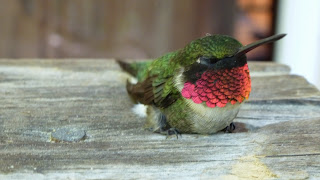
This little guy flew into the house when the back door was open. It must have been attracted by something which resembled a flower. We do have a watercolor of some flowers in a vase, hanging on the wall. Flying into a window must have stunned it. I was able to pick it up and place it outside for a short recovery period before it flew off. The feathers have an unusual shape and vivid colors.


Tuesday, May 5, 2015

April 26 Bent Arm Manway

Where are we?

Bent Arm manway connects Cucumber Gap and Miry Ridge trails. If it is not on your map, you can easily see its route on a topo map. It follows a ridge like a bent arm or dog leg. Judging from the stonework we saw, it was probably a CCC built trail. It appears to have been neglected for years but now is seeing some use. Many of the rhododendrons in the middle section have been trimmed so they don't slap you as much.

Fringed Phacelia 

Jenny Bennett led this Smoky Mountain Hiking Club outing on a rainy Sunday. We began up Jake's Creek trail to the gap with only a short break at camp 27. At the gap, we sipped a little water and headed up Miry Ridge Trail. We stopped briefly in the heath bald which would have looked much different without the mist and fog. Shortly thereafter we ate lunch at camp 26 in light rain.

Then it is off trail. There is a easy to follow faint path to start. It is not benched so it is a bit difficult. I brought one pole at Jenny's suggestion, to handle this type terrain. We get on the top of the ridge and there is some difference of opinion as to how best to traverse this section. Michael, who is guided by Lord Garmin, prefers one way and the rest of us follow Jenny on an intermittent path. We become separated and have to halloo to meet up.

About this time, we begin to enter a field of Phacelia (above). It looks like a light snow has fallen.

As we head downward, the next section is more of an old two track which has narrowed with time. This is where I first see the rockwork which leads us to think the CCC built the trail. There is lots of rhododendron here but we can walk upright and pass through it with minimal scrambling.

Quartz in Beech

I wanted to see the quartz in the tree, having read that it might be a boundary marker, possibly from an 1802 survey. Ken Wise doubted this since it was not located directly between Blanket Mountain and Mt Collins. Later correspondence with Ken and a friend of his, indicates this very likely was not a marker for those historical surveys. There was an original survey done in the 1700's between Indian nation and British territory. In 1802 and later dates, that line was resurveyed. This marker is too far from that line to have been in one of those surveys.


These Lady Slippers were a pretty sight. Someone counted 16 in this vicinity.


Jan 4 Upper North Prong Hannahs Creek

  Hiking from the dam at  Plantation Road, up the creek toward Fern Valley. I've did this years ago but don't have any photos, so he...